East of the Rocky Mountains, there was a mixture of worsening and improving drought conditions this past week.
With the passage of a couple of frontal boundaries across the eastern contiguous United States, in addition to a steady moisture flow from the southwestern CONUS into parts of the central Plains, several areas across the eastern two-thirds of the U.S. received heavy precipitation. However, heavier amounts varied greatly from region to region and were highly localized east of the Mississippi River.
Rates of evaporation of moisture from land and vegetation (known as evapotranspiration) are high across the eastern CONUS, due in large part to several days of excessive heat. Therefore, targeted improvements are depicted in regions picking up above normal precipitation (at least 1 inch above normal rainfall for the week) and where improvements to soil moisture and stream flows were apparent.
Given the very dry and hot antecedent conditions leading up to this past week, drought degradation is merely halted in most other areas receiving above normal rainfall, as indicators did not show marked improvements. Conversely, for locations receiving below normal rainfall, another week of degradation is warranted.
In the West, the Four Corners region was the beneficiary of yet another wet week, aided by a couple of low-pressure systems bringing an influx of moisture into the region. Elsewhere in the West, conditions worsened, with several pockets of abnormal dryness popping up and the expansion of drought conditions, particularly across the northern Rockies.
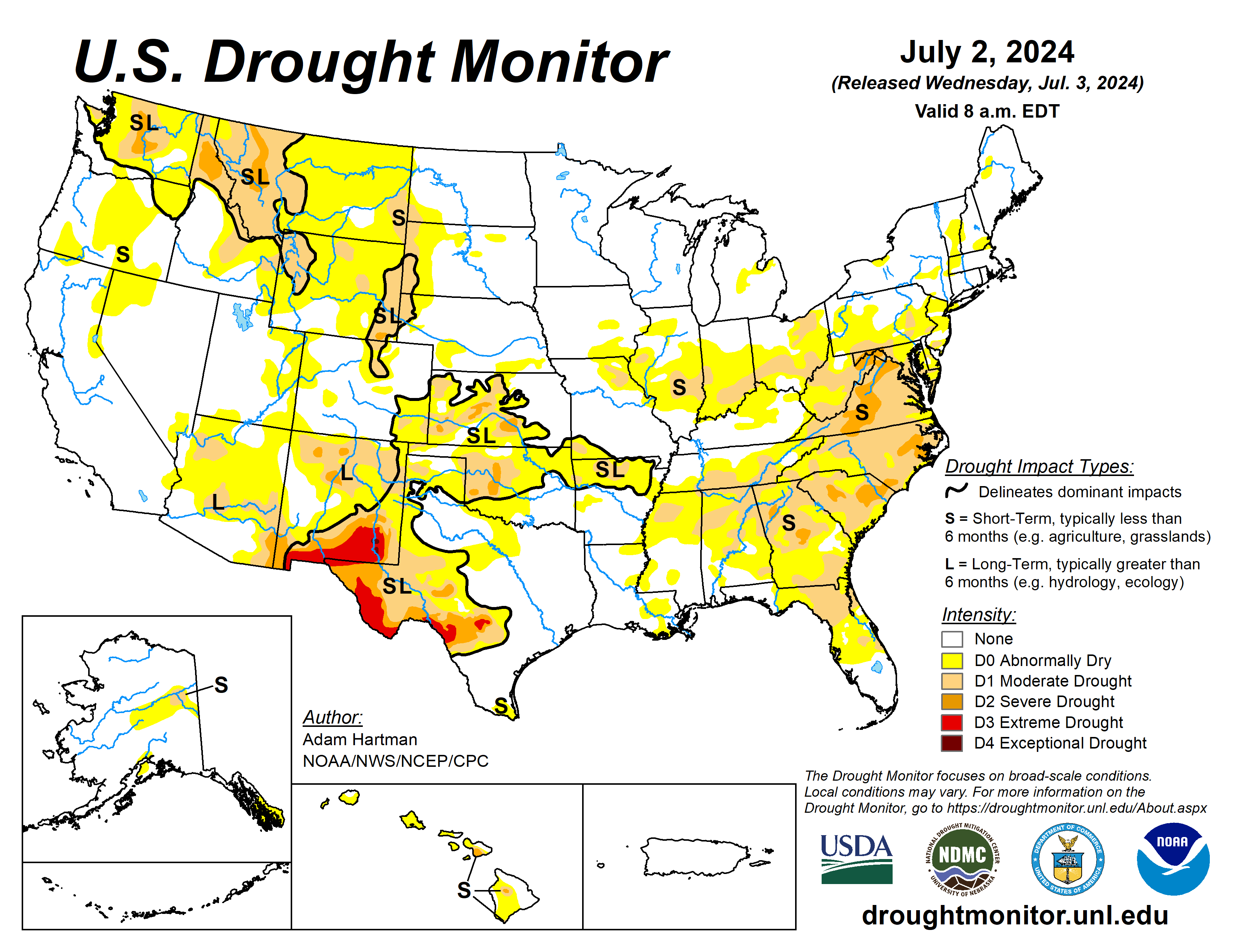
The U.S. Drought Monitor is jointly produced by the National Drought Mitigation Center at the University of Nebraska-Lincoln, the U.S. Department of Agriculture and the National Oceanic Atmospheric Administration. (Map courtesy of NDMC.)
South
Expansion of drought and abnormal dryness is warranted in the South, as much of the region experienced another week of hot and dry conditions, and this has been the case since the start of June for many locations.
The only areas where improving conditions were observed is across northern Oklahoma, extending into Kansas, where another week of heavy rain fell (locally more than 3 inches in north-central Oklahoma).
After a very wet May, precipitation has been lacking entirely across large parts of central and eastern Texas, extending eastward into Louisiana. Indicators have shown a drying trend and topsoil moisture has really started to dry out. These areas will bear watching in the coming weeks.
Midwest
Precipitation has mainly been confined to the upper Midwest and Great Lakes due to high pressure dominating the eastern U.S. in recent weeks and keeping the storm track displaced farther northward.
Weekly rainfall in excess of 3 inches was widespread, leading to improvements across parts of northern Ohio, Indiana, and Illinois, extending into the central Corn Belt. The Upper Midwest and central Corn Belt remain very wet, with ongoing flooding along the Lower Missouri and Upper Mississippi Rivers and nearby tributaries.
High Plains
The High Plains region experienced a mixture of both deteriorating and improving drought conditions, which has also predominantly been the case over at least the last month. A couple of troughs of low pressure moved across the western and central U.S., helping to tap into some moisture from the Pacific Ocean and draw it into the region.
This resulted in heavy rainfall across parts of the Four Corners and extending eastward into the central and eastern Plains. Parts of Kansas and eastern Nebraska received well in excess of 3 inches of rainfall.
Unfortunately, several locations across the western High Plains region were not so lucky and received below normal weekly rainfall. Temperatures were also unseasonably warm, running anywhere from 4 to 8 degrees Fahrenheit above average for the week in many areas, helping to exacerbate worsening conditions.
West
In the western U.S., drought improvements were limited to southern parts of the region, where a couple of troughs of low pressure were able to bring some moisture from the Pacific Ocean northward into the Desert Southwest and Four Corners.
Looking ahead
During the next five days (July 3 to 7), high pressure is likely to build over the western U.S., leading to hot, potentially record-breaking temperatures and below normal precipitation. Farther eastward, east of the Rockies, temperatures are forecast to become more seasonal for the most part.
In addition, parts of the middle and upper Mississippi Valley are likely to experience a couple of rounds of heavy rainfall.
The Climate Prediction Center’s July 8 to 12 outlook, favors enhanced chances of above average, potentially record-breaking, temperatures across parts of the Intermountain West, with above normal temperatures changes extending into the western Plains, along the Gulf Coast, and into the eastern U.S.
Below normal temperatures are favored in the interior central U.S. Near and below normal precipitation is likeliest across the western and north-central U.S., with above normal precipitation favored elsewhere. Eyes will be on the tropics over the next six to 10 days, with enhanced chances for above normal precipitation across southern Texas and the western Gulf Coast.
Adam Hartman is with the National Oceanic Atmospheric Administration, National Weather Service, National Centers for Environmental Prediction, and Climate Prediction Center.


