The first landfalling tropical storm of the season came ashore in east Texas and brought significant precipitation to the area and up into the Ozark Plateau. Temperatures were cooler than normal over a large extent of the country from the Rocky Mountains and into the Plains and Midwest where departures from normal temperatures were 3 to 9 degrees Fahrenheit below normal.
Excessive heat dominated the West Coast where departures from normal temperatures over much of California were 12 to 15 degrees above normal. Many records were set, including 120 degrees in Las Vegas, beating the old record by 3 degrees, while Death Valley had 5 consecutive days with high temperatures over 125 degrees topping out at 129 on July 7. Near-normal to slightly above-normal temperatures dominated much of the East and Southeast.
Along with the heat, much of the West was dry during the last week. Areas of the Plains recorded well above-normal precipitation with some areas receiving 400 to 800% of normal precipitation for the week. Spotty rains were common over the Southeast with a very typical summertime pattern of widely scattered thunderstorms accounting for most of the precipitation.
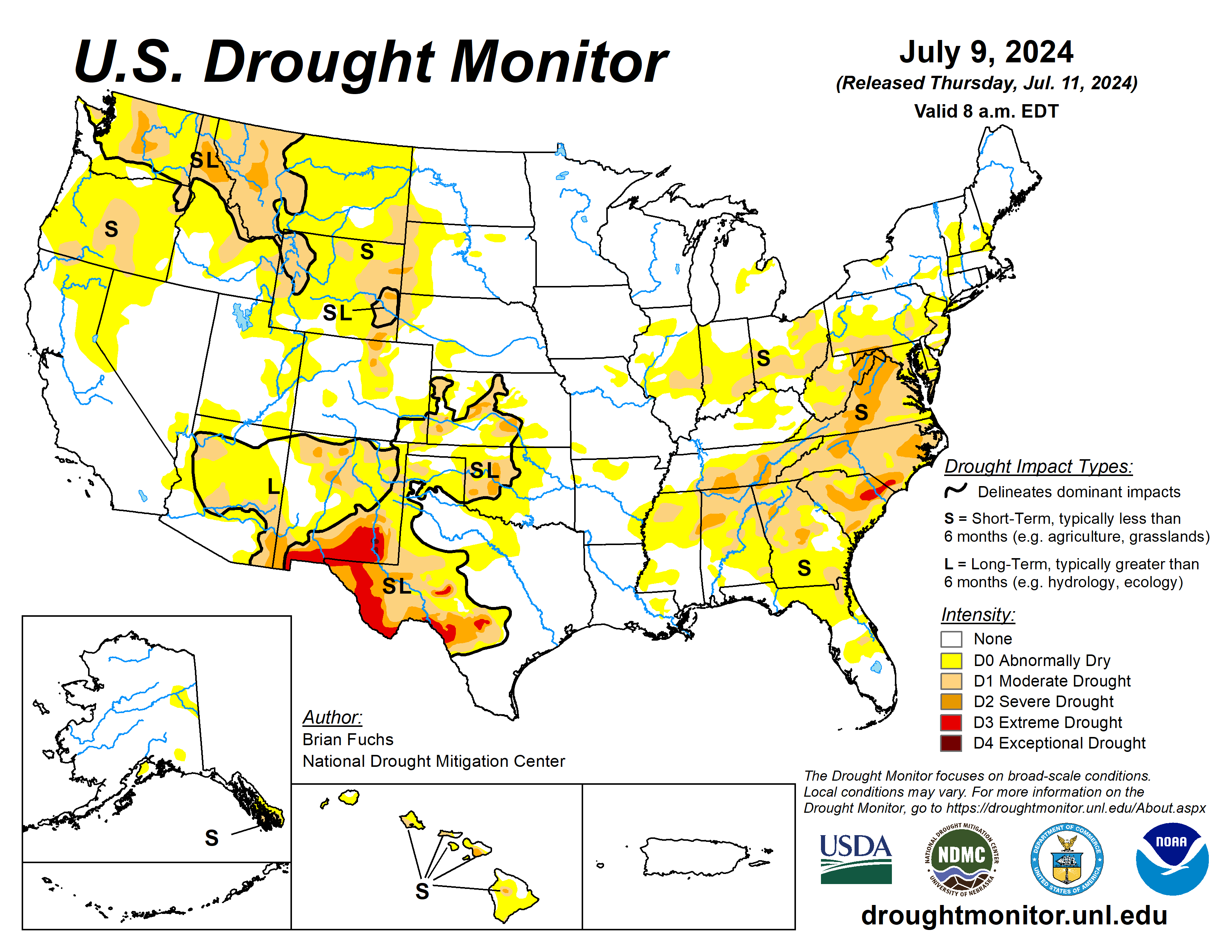
The U.S. Drought Monitor is jointly produced by the National Drought Mitigation Center at the University of Nebraska-Lincoln, the U.S. Department of Agriculture and the National Oceanic Atmospheric Administration. (Map courtesy of NDMC.)
South
Outside of western Oklahoma and north Texas where temperatures were 4 to 6 degrees below normal, most of the rest of the region was 4 to 6 degrees above normal for the week. The greatest rains fell over Oklahoma and into portions of central and north Texas.
Significant rains were associated with Beryl in east Texas into Louisiana and Arkansas. Those areas that did miss out on rains coupled with the warmer-than-normal temperatures did see drought expand and intensify, mainly over west Texas.
Severe and extreme drought expanded over west Texas while all the moderate drought was improved over Arkansas with some additional abnormally dry areas removed. Even with the significant rains in western Oklahoma, only slight improvements were made to the moderate drought and abnormally dry conditions as long-term conditions remained dry in this region.
Midwest
Temperatures over most of the region were below normal for the week. The coolest areas were in the north and west portions of the Midwest with areas of Iowa and Minnesota 4 to 6 degrees below normal for the week. The southern and eastern areas of the region were warmer than normal with southern Missouri, Kentucky and eastern Ohio 2 to 4 degrees above normal.
Most of the region recorded some precipitation with the wettest areas over Iowa, northern Missouri, southern Minnesota, southern Illinois, southern Indiana and most of Wisconsin where 200 to 400% of normal precipitation was measured.
Abnormally dry and moderate drought conditions were improved over Iowa and northern and southwest Missouri.
High Plains
Like the Midwest, most of the region recorded precipitation during the week with pockets of heavier rains in Nebraska, Kansas, South Dakota and southeast Colorado. Cooler-than-normal temperatures dominated the region with almost all areas below normal for the week.
The greatest departures were in Nebraska, South Dakota and Wyoming with temperatures 6 to 8 degrees below normal. With much of the region drought free, there were pockets of improvement over Nebraska, western Kansas and southeast Colorado where abnormally dry and moderate drought areas were reduced.
Dryness in the Black Hills of South Dakota remained, and some expansion of severe drought took place this week. The driest areas remained in eastern Wyoming and eastern Colorado, where most places did not record much precipitation this week and moderate and severe drought conditions expanded along with more abnormally dry areas.
West
It was a hot and dry week over the region with only some spotty precipitation in areas of California and Idaho and more widespread precipitation over Montana, western Colorado, and New Mexico. Temperatures were above normal over most all the West with only Idaho, Utah, Montana, Colorado and northern New Mexico below normal for temperatures.
Additional expansions of abnormally dry conditions were over southwest Wyoming. Improvements were made this week in western Montana to the severe drought and the moderate drought in northern New Mexico. Abnormally dry conditions were removed over much of southwest Colorado.
Looking ahead
Over the next five to seven days, some monsoonal precipitation is anticipated over portions of the Southwest, but most of the West overall remains quite dry. The dryness is anticipated to develop over much of the Plains and continuing over much of the Southeast. The Midwest is anticipated to remain wet. The Southwest into western and southern Texas is anticipated to be cooler than normal, albeit slightly.
The six- to 10-day outlooks show that much of the country is anticipated to have above-normal temperatures during the period, with the greatest chances over the northern Rocky Mountains and the Southeast.
The highest chances of above-normal precipitation will be over the Four Corners region and along the Rio Grande in Texas as well as over the coastal regions of the Carolinas. The best chances of below-normal precipitation occurring are from the northern Rocky Mountains into the Great Basin and into central California.
Sign up for HPJ Insights
Our weekly newsletter delivers the latest news straight to your inbox including breaking news, our exclusive columns and much more.
Brian Fuchs is with the National Drought Mitigation Center.


