Extremes in weather felt across US
Heavy precipitation fell across parts of the southern and eastern United States and in parts of the West. The Sierra Nevada had a major blizzard that significantly increased snowpack in that range.
The Great Plains were mostly dry this past week, as were parts of the Midwest, except for rain in parts of Illinois, southeast Wisconsin and Michigan. Temperatures were near or below normal in much of the western U.S. particularly west of the Continental Divide.
In most of the central and eastern U.S., temperatures were near or above normal, especially in the Upper Midwest and Great Lakes, where temperatures from 10 to 15 degrees Fahrenheit warmer than normal were common.
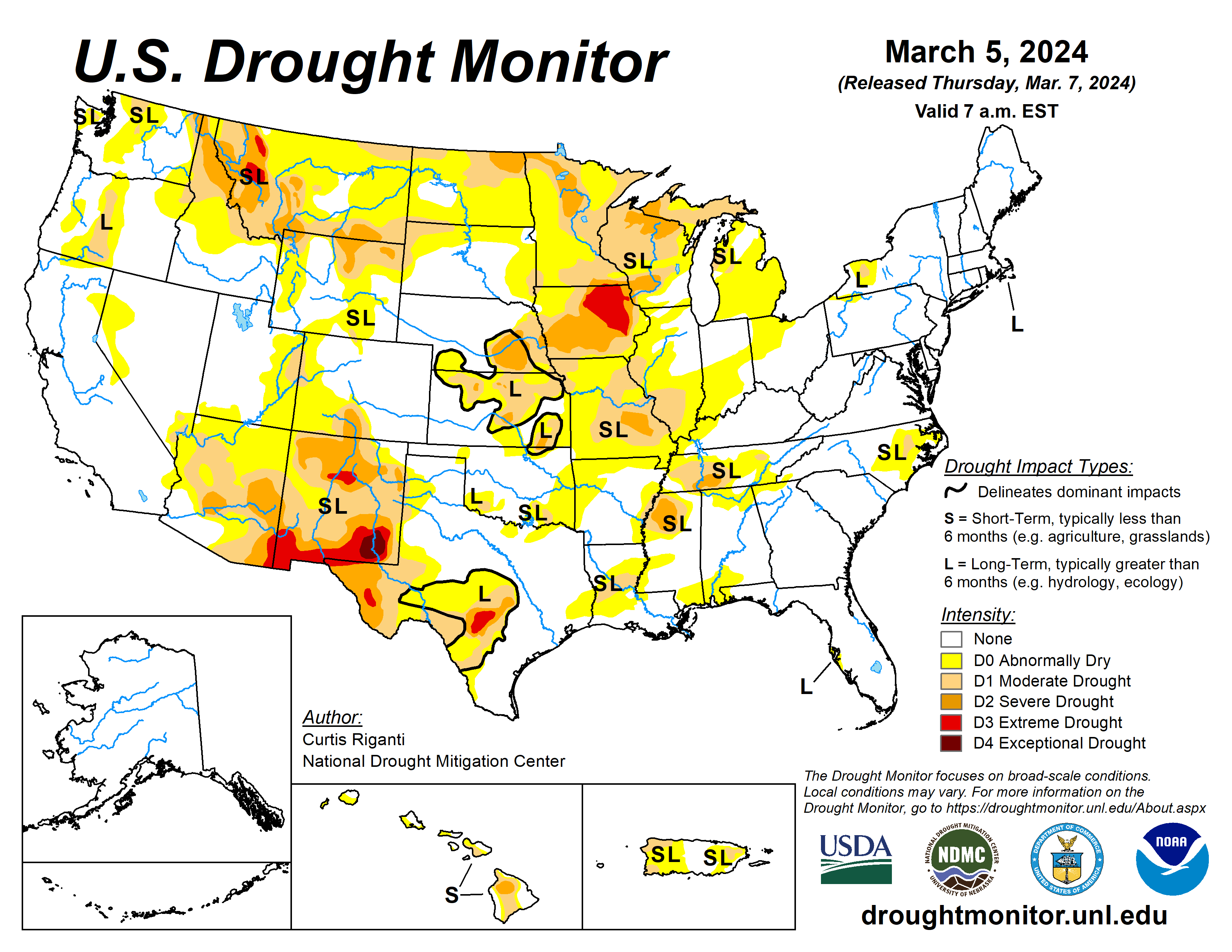
The U.S. Drought Monitor is jointly produced by the National Drought Mitigation Center at the University of Nebraska-Lincoln, the U.S. Department of Agriculture and the National Oceanic Atmospheric Administration. (Map courtesy of NDMC.)
South
Moderate to heavy rain amounts fell across portions of Louisiana and Mississippi. Elsewhere, mostly dry weather occurred in the region, aside from isolated heavy rain from a thunderstorm in north-central Arkansas. Temperatures across the region were mostly either near normal or 5 to 10 degrees above normal, with a few spots in Texas coming in 5 to 10 degrees below normal.
Recent rainfall continued to alleviate precipitation deficits in eastern Louisiana and in Mississippi, leading to some improvements in areas of moderate drought and abnormal dryness.
In southwest Louisiana, short-term dryness and warmth and lowering streamflow levels led to a small expansion of moderate drought conditions. Abnormal dryness spread across parts of northern and western Arkansas, and a few isolated spots in Texas and Oklahoma. Short-term precipitation deficits, warm and windy weather, and low soil moisture were also noted.
Midwest
In Illinois and Missouri, abnormal dryness and moderate drought expanded in coverage as short-term precipitation deficits grew amid warm and windy weather and lowering soil moisture levels. An area of severe drought developed southwest of St. Louis where streamflow deficits also worsened.
Moderate and severe drought locally increased in coverage in northeast Minnesota as precipitation deficits mounted along with warmer-than-normal weather. A significant snow drought continued in the region, as Duluth, Minnesota, is now 50 inches below normal for snowfall this season, according to the Minnesota State Climate Office.
Short- and long-term precipitation deficits, warm and windy recent weather, and low soil moisture and groundwater levels led to a localized expansion of extreme drought in central Iowa. In southeast Iowa, despite wetter weather in January, creeks, rivers and pond levels are still low. This is indicative of the short- and long-term significant drought conditions across much of Iowa.
High Plains
Mostly dry weather occurred in the Great Plains portion of the High Plains region this week. Temperatures in the region ranged from mostly 5 to 10 degrees warmer than normal for far eastern Wyoming and Colorado and most of Kansas, Nebraska and South Dakota. Also near or below normal temperatures in North Dakota, western Colorado and western Wyoming.
Some of the mountainous parts of the region received significant snowfall, especially in west-central and northwest Wyoming and in the Medicine Bow Mountains in northern Colorado and south-central Wyoming.
Improving snowpack levels led to reductions in coverage of moderate and severe drought and abnormal dryness in these areas. Improvements were more limited in southern Wyoming, where grass fires were reported west of Cheyenne recently and only light snow amounts were reported in the high plains west of Laramie. Given short-term dryness and high recent evaporative demand, abnormal dryness and moderate drought were expanded in northwest South Dakota, southwest North Dakota, and adjacent southeast Montana.
West
Heavy precipitation fell this week across much of the central and northern Pacific Coast, and heavy snow also fell in a major storm in the Sierra Nevada. Significant snow amounts also fell across parts of Idaho and northwest and southwest Montana. Improving snowpack in these areas and lessening precipitation deficits led to improvements in drought or abnormal dryness in numerous locations.
Along the Arizona-New Mexico border, severe drought coverage was locally reduced in a reassessment of short- and long-term drought conditions.
Looking ahead
Through the evening of March 11, the National Weather Service’s Weather Prediction Center is forecasting widespread precipitation amounts of at least a half inch across much of the central and eastern U.S. (roughly from the Interstate 35 corridor eastward), excluding northern Wisconsin, Minnesota, the Michigan Upper Peninsula, the Florida Peninsula, and central and south Texas.
Within this area of precipitation, swaths of at least 1.5 inches of liquid precipitation are forecast from southwest Missouri to southeast Michigan, from southwest Mississippi to central North Carolina, and across most of New England.
In the West, mostly drier weather is expected, though some higher precipitation amounts can be expected in the western mountains of northern California, western Oregon and western Washington.
Looking ahead to March 12 to 16, the National Weather Service Climate Prediction Center forecast favors warmer-than-normal temperatures across the central and eastern U.S., with the highest confidence for warmer-than-normal weather centered around the Upper Midwest and Great Lakes
The forecast favors near- or below-normal temperatures in the Intermountain West, and above-normal temperatures along the West Coast. Above-normal precipitation is favored across large portions of the central and southern U.S., especially in Colorado and New Mexico and the adjacent western Great Plains and in the Deep South and along the Central Gulf Coast.
Curtis Riganti is with the National Drought Mitigation Center.
Related Articles


