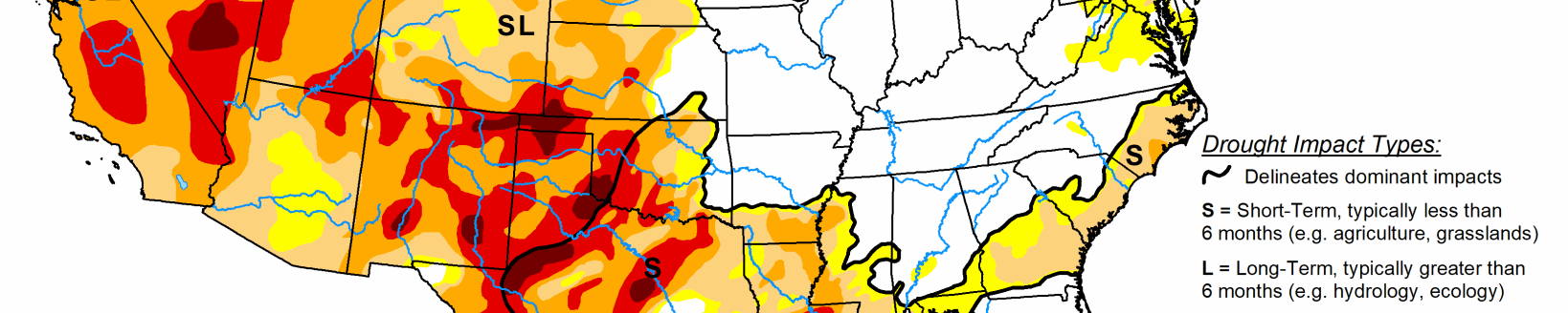
Rapidly intensifying “flash drought”—attributed in part to extreme late-summer heat—continued to afflict many areas from the lower Midwest and Mid-Atlantic States to the Gulf Coast, according to the Sept. 17 U.S. Drought Monitor released Sept. 19. Likewise, an abysmal Southwestern monsoon (to-date) led to increasing drought intensity and coverage in Arizona, while short-term drought persisted across the Hawaiian Islands. Conversely, moderate to heavy rain eased or alleviated dryness and drought from the Great Lakes into the Northwest as well as in southwestern Alaska and southern Puerto Rico.
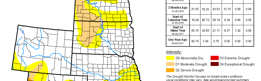
Widespread moderate to heavy rain (1 to 6 inches, locally more than 8 inches) over the northern half of the region contrasted with pockets of dryness and drought in the southern and western High Plains Region. The rain eliminated the last vestiges of Abnormal Dryness (D0) in North Dakota and eastern Nebraska. Conversely, input from local experts as well as 60-day rainfall locally less than 50 percent of normal led to a minor expansion of D0 and Moderate Drought (D1) in southwestern Kansas. The rest of the region remained unchanged and largely devoid of dryness concerns, though D0 and D1 remained in place over western and southeastern portions of Colorado as well as southwestern Wyoming.
As with the Southeast, intense late-summer heat and acute short-term dryness led to a sharp increase in drought intensity and coverage across central portions of the region. Excessive heat (95 to 102 degrees F) and pronounced short-term rainfall deficits (30-day rainfall totaling locally less than 10 percent of normal) heightened evapotranspiration rates and soil moisture losses, resulting in quickly escalating drought impacts (often referred to as a “flash drought”.) It should be noted that “flash drought” often occurs more quickly (in terms of impacts) than the data indicates. In terms of temperatures, Sept. 18 marked the 18th consecutive day of 90-degree heat at Little Rock, Arkansas (the long term historical total-September average is 9 days); Sept. 18 also marked the 7th day with 100-degree readings at Meridian, Mississippi (only one other year—1980—had this many, and only 7 other years total had 3 or more (records dating back to 1889)). For this weeks’ analysis, the expansion of D0 (Abnormal Dryness) as well as Moderate (D1) to Extreme Drought (D3) was driven by guidance from local experts, impact reports from observers, as well as temperature- and rainfall-driven data products which focused on the past 30 to 60 days. Increases in drought were most pronounced from central and northeastern Texas into the central and northern Mississippi Delta, where 60-day rainfall has totaled a meager 25 percent of normal or less. State-wide average topsoil moisture was rated more than 70 percent short to very short (according to USDA-NASS) as of Sept. 15 in the Mississippi Delta States, and 83 percent poor to very poor in Texas (tied for second highest in the nation with Virginia, only 2 percentage points behind California’s 85 percent). Despite the generally dry, hot weather pattern, heavy showers and thunderstorms (2 to 4 inches) provided highly localized drought relief across southeastern and north-central Texas as well as western Oklahoma. After the end of the monitoring period (12z Tuesday), heavy showers associated with the remnants of Tropical Storm Imelda were bringing rain to southeastern Texas; the impacts of this rainfall will be incorporated in next week’s U.S. Drought Monitor.
Reductions to drought intensity and coverage across the northern half of the region contrasted with rapidly intensifying and expanding drought in the south. From Minnesota and northern Iowa into Wisconsin, Michigan, and northern Illinois, widespread soaking rainfall (1 to 6 inches, locally more than 8 inches) eased or eradicated lingering Abnormal Dryness (D0) and Moderate Drought (D1). Conversely, temperatures in the middle and upper 90s coupled with acute short-term moisture deficits (30-day rainfall locally less than 25 percent of normal) led to an expansion of D0 and D1, most notably from southern Illinois eastward into Kentucky and neighboring portions of Indiana and Ohio. State-wide average topsoil moisture was rated more than 40 percent short to very short (according to USDA-NASS) as of September 15 in Indiana and Ohio, and 78 percent poor to very poor in Kentucky. Reports from the field indicate Kentucky is experiencing the same type of “flash drought” being observed across much of the south; the impacts of “flash drought” often occur more quickly than the objective data indicates.
An abysmal Southwestern monsoon contrasted with increasingly wet weather in the Northwest. The Southwestern monsoon, which typically runs from June 15-September 30 and accounts for up to half the total annual precipitation in some parts of the Southwest, has featured less than 50 percent-of-normal rainfall (locally less than 30 percent). While showers over the past week in New Mexico (1-3 inches, locally more) helped stem the recent trend toward increasing drought in the east, rain bypassed most of Arizona. Input from local experts as well as mounting 6-month rainfall deficits supported an expansion of Severe Drought (D2) in the driest locales of southern and central Arizona.
Farther north, moderate to heavy rain fell for a second consecutive week from the Pacific Northwest into the northern Rockies, with the highest totals (2 inches or more) observed on the windward slopes of the mountains. This pushed two-week totals to locally more than 4 inches, spurring additional reductions of Abnormal Dryness (D0) as well as Moderate to Severe Drought (D1-D2). Reductions to D0 in the eastern Great Basin were spurred by input from local experts, who indicated a lack of any lingering impacts due to a recent uptick in precipitation in northeastern Utah (locally more than 2 inches over the past two weeks).
Related Articles