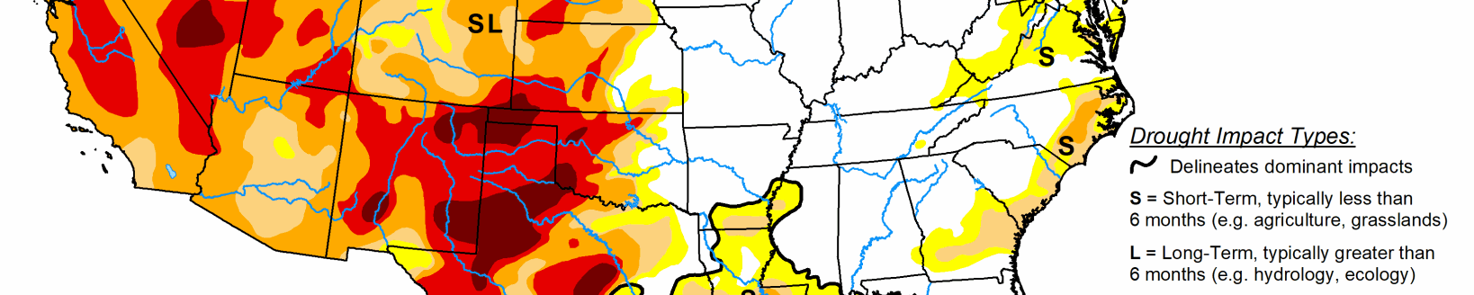
Dryness expands across High Plains region as planting begins
An active pattern of storms brought cold, wet weather to the Northeast, rain and locally severe thunderstorms to parts of the South, lower Midwest, and Southeast. Drought areas along the western Gulf Coast missed the heaviest rains, while those in the eastern half fared better. A ridge of high pressure over the West kept conditions warm and dry.
Midwest
The western half of the region saw warmer than normal average temperatures, with departures ranging from 1 degree above normal in eastern Iowa to 8 degrees above normal in western Iowa. In the eastern half, temperatures were 1 to 7 degrees below normal, with the greatest departures generally occurring in the Upper Great Lakes area. Precipitation occurred across much of the region with weekly totals generally between 0.5 and 1.75 inches. A band of 3 to 4 inches of rainfall stretched from southwest Missouri to central Illinois. The only change in the region to this week’s map was a small reduction in abnormal dryness (D0) in Minnesota.
High Plains
Temperatures across the High Plains were generally warmer than normal last week with departures of 2 to 6 inches above normal. Much of the region received less than 0.5 inches of precipitation. Exceptions included parts of eastern North Dakota, South Dakota, and Nebraska, with totals of more than 1 inch, and eastern Kansas, with amounts of more than 2 inches—nearly 200% of normal. The warm, dry conditions led to an expansion of abnormal dryness (D0) in the Dakotas, southwest Nebraska, northwest Kansas, and eastern Colorado. Additionally, moderate and severe drought (D1 and D2) expanded over Colorado’s eastern plains. This area has failed to receive the timely spring rains needed, resulting in reductions in soil moisture, streamflow, and vegetation health. Across the entire High Plains region, local drought experts are discussing the emerging dryness and closely monitoring the situation as planting begins and the need for moisture increases.
South
Locally heavy rain and thunderstorms fell across the eastern half of the southern region. The largest totals (4 inches or more) were recorded in Louisiana and Mississippi. Temperatures were near to below normal, with the largest departures (5 degrees below normal) recorded in Tennessee. For the most part, the rain either missed the drought areas near the coast or wasn’t enough to warrant improvements in conditions, instead preventing degradations. The western half of the region generally saw little or no rain again this week. Weekly average temperatures ranged from 2 to 8 degrees above normal, with locations in south Texas setting daily record highs with temperatures reaching triple digits. The warm, dry weather continued to deplete moisture supplies, stress vegetation, and deteriorate drought conditions across parts of the Texas Gulf Coast, with expansions to moderate (D1), severe (D2) and extreme (D3) drought. Texas also saw improvements as localized rain improved soil moisture, vegetation health, and streamflow.
West
Most of the western U.S. received little to no rain, except for small pockets of the Pacific Northwest and the Southwest. Temperatures were generally above normal, with record-setting heat across parts of the Southwest and daily highs of 10 to 20 degrees above normal. The heat and dry weather led to deteriorating conditions across several states. In Oregon, severe drought (D2) expanded near Portland and in the north-central part of the state in response to drying soils, vegetation stress, and streamflow and groundwater declines. Precipitation for the water year ranks as the third driest in the Portland station’s 89-year period of record. In northern California, moderate drought (D1) expanded. While the state coordination committee noted that reservoir levels are acceptable, precipitation deficits are less 50% of normal for the water year, streamflow values are low, and rangeland grasses have been affected by the lack of moisture and heat. Likewise, parts of central Nevada also saw expansions to D1 and the introduction of D2 in response to increasing moisture deficits, declining streamflow and groundwater levels, and vegetation stress. The only improvements on this week’s map included minor reductions in D1 in Oregon and D0 in Washington in response to locally heavy rainfall.