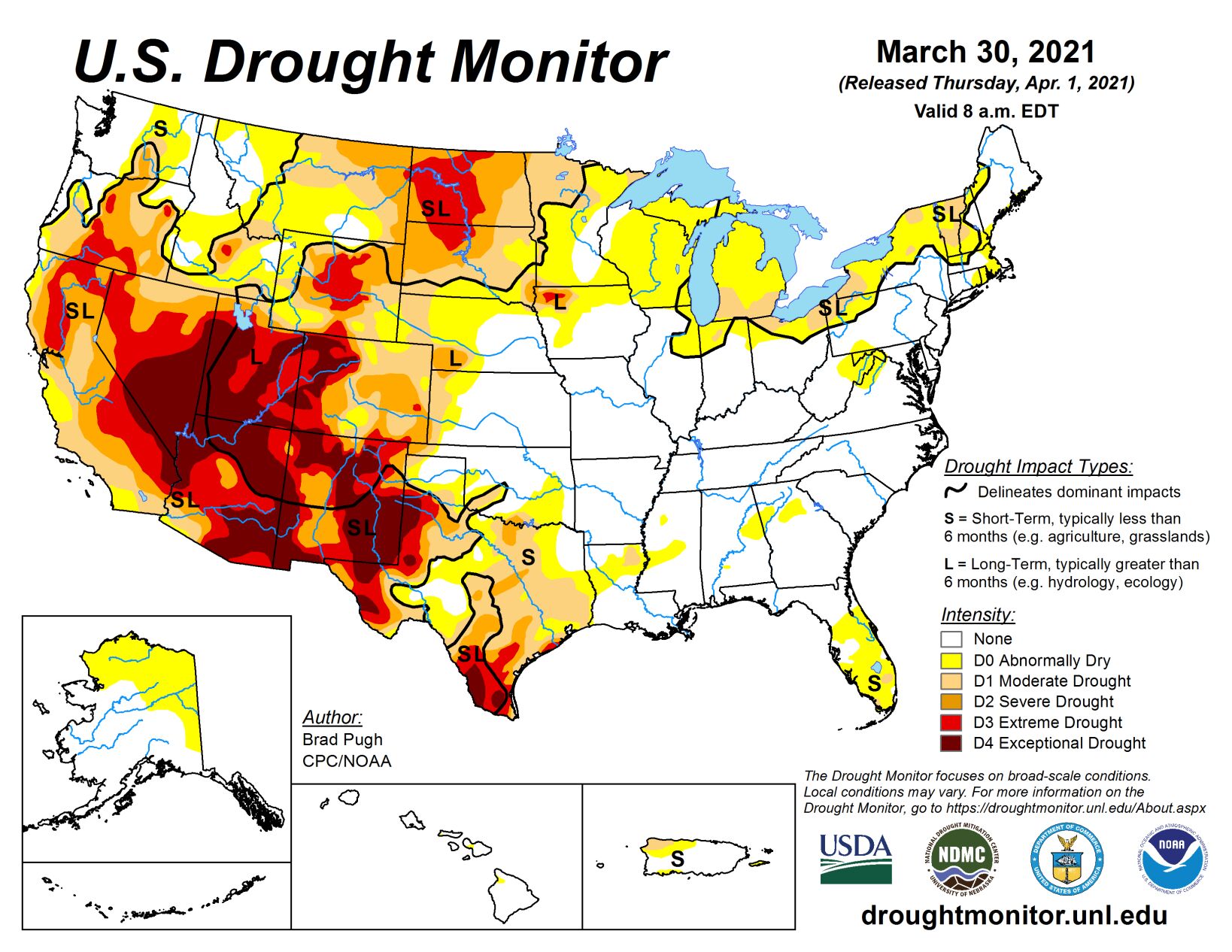
Multiple low pressure systems resulted in widespread precipitation (0.5 to 3 inches, or more) from the Mississippi Valley to the East Coast during late March. Heavy to excessive rainfall (more than 5 inches) soaked southeast Louisiana and triggered flooding across Tennessee this past week. Along with the flooding, a severe weather outbreak affected Alabama, Georgia, Tennessee, and Kentucky on March 25.
Mostly dry weather persisted farther to the south, including the Florida Peninsula and south Texas. A cold front brought strong winds to the northern Plains on March 29 but little or no precipitation. Rain and high-elevation snow was limited to coastal Washington and the northern Cascades across the Pacific Northwest, while mostly dry weather prevailed throughout California. 7-day temperatures from March 23-29 averaged below (above) normal across the western (eastern) U.S.
South
On March 23 and 24, heavy rainfall (more than 5 inches) resulted in a 2-category improvement to southeast Louisiana where soil moisture is currently above the 70th percentile. However, much less rain fell across northern Louisiana where an expansion of D0 (abnormal dryness) and D1 (moderate drought) was made. The recent heavy rainfall also led to elimination of abnormal dryness (D0) across the Mississippi Gulf Coast. Heavy rainfall triggered flooding across much of Tennessee during late March and the small areas of D0 were removed from the state. Additional improvements from the previous two weeks continued across the Texas Panhandle, while mostly dry weather and increasing precipitation deficits along with worsening soil moisture conditions resulted in expansion of D1 (short-term moderate drought) across parts of southeast Texas. Soil moisture rapidly declines from east to west across Texas.
Midwest
Widespread precipitation (1 to 2.5 inches) fell throughout much of the central and eastern Corn Belt. Abnormal dryness (D0) and moderate drought (D1) were decreased in spatial coverage across Illinois and Indiana. Despite this rainfall during late March, soil moisture (below the 20th percentile) and SPIs at various time scales support maintaining D1 across parts of northern Indiana, northern Ohio, and lower Michigan. Northeast Illinois and eastern Indiana missed out on the heavier rainfall during late March, prompting a slight expansion of D0 for these areas. Also, D1 was added to northeast Ohio based on increasing 90-day precipitation deficits, 90-day SPIs, and soil moisture below the 20th percentile. A 1-category improvement was made to eastern Minnesota and western Wisconsin where more than 1.5 inches of rainfall occurred this past week. 1 to 2 inches of rainfall resulted in a reduction in D0-D2 across central Iowa. However, SPIs dating back 9 months continue to support D2-D3 long-term drought for northwest Iowa.
High Plains
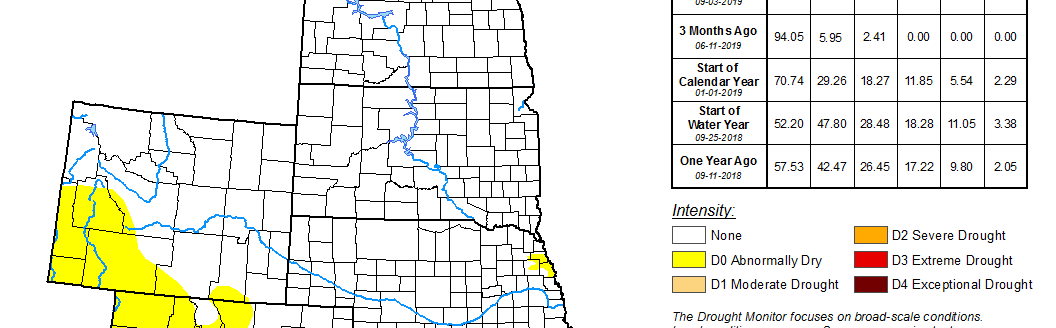
Another dry week along with strong winds on March 29 resulted in a slight expansion of extreme drought (D3) across North Dakota and northern South Dakota. This expanding D3 area was based mostly on SPI at EDDI at various time scales. Soil moisture remains below the 5th percentile for much of North Dakota. Based on snow water content running near average and 6 to 12 month SPIs, D3 was improved by one category across north-central Wyoming. Following multiple changes during the previous two weeks across Colorado, only minor improvements were needed this week. Localized improvements were made to small areas of southern Colorado, based in part on WYTD (since Oct 1, 2020) precipitation.
West
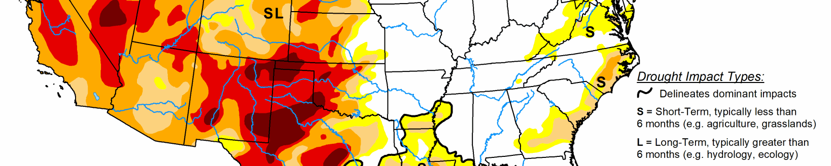
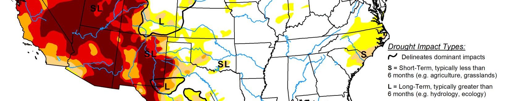
Widespread extreme (D3) to exceptional (D4) drought continues to be focused across the Southwest. According to the USDA (for the week ending March 28), nearly two-thirds of the winter wheat is rated as very poor in New Mexico. As of March 27, snow water content is running near 70 percent of average for the Sierra Nevada Mountains. Due to this snow water content along with WYTD (since Oct 1, 2020) precipitation deficits, long-term drought persists for nearly all of California. Since precipitation averaged below normal during March, the impact type was adjusted to include both long and short-term drought for California, along with parts of the Southwest. Based on SPIs at various time scales, D1 (moderate drought) was slightly expanded across north-central Montana while below average snow water content prompted an increase in abnormal dryness (D0) for northwest Montana. To the west across eastern Washington, below average precipitation during March and drying topsoil prompted an expansion of D0 and D1 (short-term moderate drought).