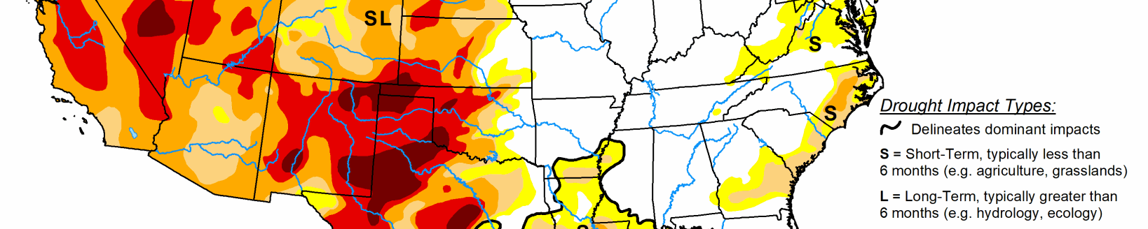
According to the Sept. 10 U.S. Drought Monitor released Sept. 12, fortunately for the Southeast, Category 5 Hurricane Dorian stalled just east of central Florida, slowly weakened, and gradually turned northward, finally accelerating northeastward into Nova Scotia and Newfoundland. Its only U.S. landfall was at Cape Hatteras. Unfortunately, it stalled over the northern Bahamas for 1-2 days, devastating the islands of Great Abaco and Grand Nassau. Rainfall from Dorian was limited to coastal sections of eastern Florida, the Carolinas, Delmarva Peninsula, Cape Cod, and extreme eastern Maine. Between 5-10 inches of rain, locally to 15 inches, fell along coastal northeastern South Carolina and eastern North Carolina, although the totals sharply dropped off to the west. A second tropical system, Tropical Storm Fernand, made landfall in northeastern Mexico, but its outer bands of rain brought welcome rains to southern Texas. Frequent cold fronts raced across the northern tier of States, dropping light to moderate precipitation on the Northwest, northern Rockies and Plains, Midwest, upper Great Lakes region, and northern New England. Monsoonal moisture produced light showers in western Texas, central New Mexico, Colorado, and into Wyoming and Idaho. Dry weather prevailed in western sections of the Southwest, south-central Plains, lower Mississippi Valley, and across much of the Southeast, eastern Ohio Valley, and mid-Atlantic. Temperatures averaged above-normal across the West, southern two-thirds of the Plains, and across the Southeast, with subnormal readings confined to the northern Plains, upper Midwest, Great lakes region, and Northeast.
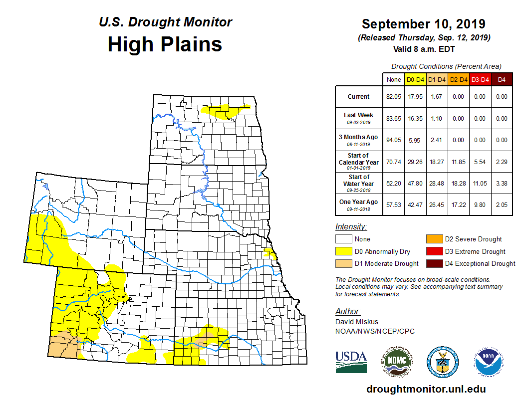
Unsettled weather brought widespread light precipitation to much of the High Plains, especially Montana and the Dakotas, while monsoonal moisture produced scattered showers in Colorado, western Nebraska, and parts of Kansas and Wyoming. With much of the region drought-free, the rains fell on top soils with adequate to surplus moisture. The few areas with D0 or D1 did receive precipitation, and some improvements were made. In northwestern Montana, 2-3 inches of rain in the Mission Mountains and widespread 1-2 inches across Lake and Flathead counties have produced near record maximum stream flows for this time of year. With 60- and 90-day totals now at normal or surplus, D0 was removed, and D1 shrunk to just include Lincoln County where weekly amounts were somewhat lower, and short-term deficits still remained. In North Dakota, another week of rain (0.5-1.5 inches) continued to reduce short and medium-term deficiencies, with D1 removed and the D0 shrunk to better fit dwindling 60-day deficits. In central Colorado, 1-2 inches of rain south of Denver eliminated short-term deficiencies, thus D0 was erased. Farther to the southwest and southeast, however, dry and warm weather increased 90-day deficiencies as the southwest monsoon has been weak and spotty, generating SPIs less than -1.5 on a 30-, 60-, and 90-day time scales. The wet winter and spring is fast becoming a faded memory as the summer heat and dryness continued to assert itself with impacts. Accordingly, D0 expanded into Gunnison, Pitkin, and Saguache counties in the southwest, while D0 increased in Las Animas and Otero counties in the southeast. D1 also slightly crept northward in southwestern Colorado.
Widespread light to moderate rains (0.5-2 inches) fell across the western and northern sections of the Midwest as several frontal systems dove southeastward out of Canada. The heaviest rains (1.5-3.5 inches) were reported across western and northern Minnesota, while bands of scattered thunderstorms moved across parts of Iowa, southern Wisconsin, northern Illinois, and the UP of Michigan. In contrast, little or no rain fell across southern and eastern portions of the Midwest (southern Missouri and Illinois, most of Indiana, southern lower Michigan, and much of Ohio and Kentucky). Not surprisingly, some improvement was made where the greatest totals occurred that greatly reduced or alleviated short-term deficits. This included around Duluth, MN; southwestern, central, and northeastern Iowa; northern Illinois; and the eastern UP of Michigan. Dry weather meant deterioration, and this occurred in northwestern Indiana and southern lower Michigan (D1 expansion); new D1 areas in southwest Ohio, southern Indiana, and central Kentucky; and D0 increase across central and eastern Kentucky. 60-day shortages reached 3-6 inches in the new D1 areas, while most of the D0 areas only received 50-70% of normal precipitation. Kentucky had the highest percent short to very short topsoil moisture value (61%), with Iowa, Michigan, Illinois, Indiana, and Ohio not far behind (between 30-42%). Although the dry weather is good for crop maturation and corn dry down, the wet spring delayed planting, so some crops may be behind schedule and could use rain for filling (mainly soybeans).
Mostly dry and warm weather enveloped much of the South, contributing to a rapid decline in short-term moisture conditions across most of Texas, southwest and southeast Oklahoma, southwest Arkansas, and northwest Louisiana. Even a few pockets of D0 were introduced in formerly wet central and northeastern sections of Tennessee. The few exceptions to this were outer bands of rain across southern Texas from Tropical Storm Fernand (which made landfall in northeastern Mexico), some light monsoonal showers in southwestern Texas and the northern Texas and Oklahoma Panhandles, and Day7 thundershowers in northern Louisiana and central Arkansas. A general 1-category improvement was made across southern Texas in response to 1-3 inches (locally 5 inches) of rain, while some slight improvements were made around the Midland area, Trans Pecos region, and in extreme northern Louisiana. In contrast, September’s climatologically higher rainfall totals for Texas and Oklahoma make degradation faster, and temperatures have remained high. Where little or no rain fell, a 0.5-1 category downgrade was made, especially in central Texas, but also in southwest and southeast Oklahoma, and bordering sections of Arkansas and Louisiana. According to USDA, percentages for both topsoil and subsoil moisture for Texas stood at 85 and 79%, respectively, as of Sep. 8, while topsoil moisture grew increasingly short to very short in Arkansas (67%), Louisiana (60%), Mississippi (66%), and Tennessee (52%). Even with the USDA topsoil moisture figure, Mississippi remained D0-D4 free as the entire state still had 60-day precipitation surpluses. Texas pasture and range conditions have been affected by the warmth and dryness, with 48% rated poor or very poor according to the Sep. 8 USDA/NASS report.
Related Articles