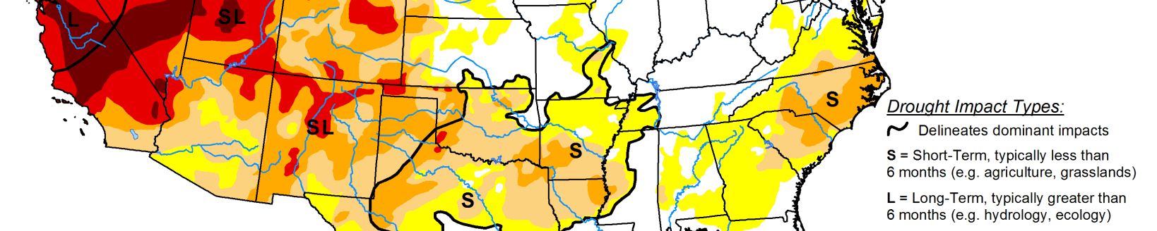
A series of strong Pacific weather systems moved across the contiguous U.S. during this U.S. Drought Monitor week. The first system early in the week spread precipitation across Wyoming to the Upper Mississippi Valley, then left scattered showers over the Northeast before moving off into the Atlantic. The second brought precipitation to northern California and the Pacific Northwest. Its surface low weakened as it crossed the Rockies, but it was re-energized over the Plains and generated precipitation across the central Plains, Great Lakes, and Northeast. The third system slammed into the West Coast near the end of the week. Fed by an atmospheric river of Pacific moisture, its surface low and front left heavy precipitation across California with widespread rain and some high elevation snow from California and the Pacific Northwest to the Great Basin.
According to the National Weather Service Weather Prediction Center, as the third low pressure system approached the Pacific Northwest coast, it set a pressure record, testifying to the strength of the system. The Oct. 24 pressure was 942.5 mb, which is a record low pressure for the Pacific Northwest. The end result of these weather systems was above-normal precipitation for the week across much of the West, including the Pacific Northwest, California, Nevada, and the central to northern Rocky Mountains; across eastern portions of the northern and central Plains, the southern Great Lakes, and western and southern portions of the Northeast; and a band of precipitation from southeast Kansas to eastern Kentucky.
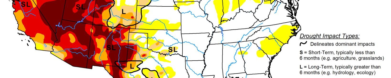
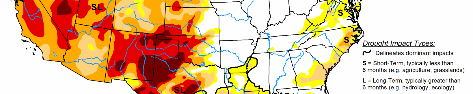
The precipitation improved short-term conditions, especially in the West, with soil moisture, streamflow, and 1-month to 6-month Standardized Precipitation Index indicators sliding into the wet categories. Other drought indicators, such as vegetation-based VHI and VegDRI, were slower to respond. Groundwater, reservoir levels, and longer-term (9-month to 72-month) SPI indicators still indicated very dry long-term drought conditions in the West and northern Plains. The rest of the CONUS was drier than normal, with little to no precipitation falling across much of the Southwest, central and southern Plains, Lower Mississippi Valley to Southeast, northern reaches of the Upper Mississippi Valley, and northern Maine. Weekly temperatures were warmer than normal in the Pacific Northwest to northern and central Rockies, the southern Plains to Gulf of Mexico coast, and along the eastern seaboard. Temperatures averaged cooler than normal in California and the northern Plains to Upper Mississippi Valley. Drought contracted or was reduced in intensity in parts of the West and Midwest, but expanded or intensified in the southern Plains, central High Plains, and Southeast.
South
Temperatures were hot this week in the South, with some record high temperatures recorded in Louisiana. Parts of northern Tennessee received an inch or more of precipitation, and patches of half an inch occurred over parts of central Arkansas, southern Mississippi, and coastal southeast Texas. Otherwise, most of the South received no precipitation this week. Drying soils and vegetation prompted expansion of D0 and D1 from the ArkLaTex region to west-central Mississippi. D0, D1, and D2 (severe drought) expanded in parts of eastern, northern, and southern Texas.
Midwest
Much of the southern and central portions of the Midwest received heavy precipitation, with a band of 2 to locally 4 inches measured from Iowa and northeast Missouri to southern Michigan and northwest Ohio. Areas to the south and north had 0.5 to 2.0 inches, except for a dry spot in southeast Minnesota to central Wisconsin and a dry swath in central Missouri. The northern half of Minnesota received no precipitation. D0 to D2 contracted in Iowa and Illinois, D0-D1 were reduced in Missouri, and D0 was shaved in southwest Minnesota. But D0 and D1 expanded in parts of Wisconsin.
High Plains
Half an inch to an inch of rain was widespread across Wyoming and South Dakota to eastern Nebraska, with up to 2 inches falling across southeast Kansas. Otherwise, little to no precipitation occurred elsewhere in the High Plains region. D0 was trimmed in eastern Nebraska and D0-D1 trimmed in southeast Kansas. D1 and D3 (extreme drought) were reduced in Wyoming, and D2 and D3 contracted in western Colorado, but D0-D2 expanded in eastern, central, and southern Colorado. According to USDA statistics, 73% of the pasture and rangeland in North Dakota was in poor to very poor condition, with the statistics 78% in South Dakota, 55% in Wyoming, 49% in Colorado, 31% in Nebraska, and 26% in Kansas.
West
Two inches to over 10 inches of precipitation fell across the West from the coast to the Sierra Nevada and Cascade ranges, over 2 inches was widespread across central Idaho and in parts of Nevada and Utah, with over half an inch over the rest of the Pacific Northwest into southern California, most of Nevada, and western and northern sections of Utah. Less than half an inch to no precipitation fell over the deserts of southern California and southern Nevada, over southeast Utah, and most of Arizona. New Mexico and parts of Montana were dry this week.
A volunteer observer west of Reno, Nevada, recorded 6.83 inches of precipitation from the storm, while South Lake Tahoe measured 7.07 inches for the USDM week. Some all-time daily precipitation records were broken October 24 in northern California. These include 5.44 inches at Sacramento City (breaks the previous record of 5.28 inches from April 20, 1880), 5.41 inches at Sacramento Exec Airport (previous record was 3.77 inches on October 13, 1962), and 10.40 inches at Blue Canyon (exceeded the previous record of 9.33 inches from December 22, 1964).
The heavy rains which fell over a short period of time resulted in transient rises on local creeks, ponding of water, mud and rock slides, and some debris flows over recent burn areas. So much rain falling so quickly likely mostly ran off and had little chance to soak into the soil. But the rain wetted the soils prior to the building of the winter snowpack which will help in the future. While beneficial, the precipitation improved hydrological conditions only marginally.