Heavy snow falls in Kansas, Colorado, improving ongoing drought
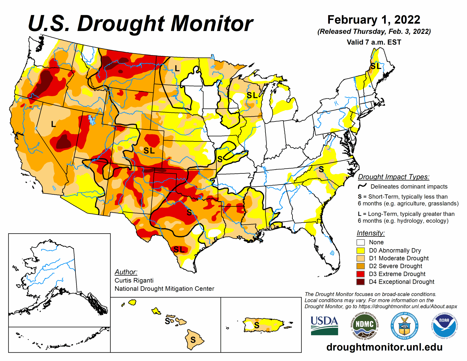
With a few notable exceptions, the past week was mostly dry in the contiguous U.S. Heavy rain fell in southeast Texas this week, where large parts of ongoing drought or abnormal dryness saw improvement or full removal. Widespread precipitation of over a half inch fell in the Pacific Northwest, though this was primarily in areas not experiencing drought or was not enough to result in improvements to drought conditions.
Heavy snow fell in a localized band across parts of western Kansas and eastern Colorado, totaling 27 inches at Mt. Sunflower, Kansas. Snow also fell in the Denver area. These snow events allowed for improvement to ongoing severe and extreme drought.
Finally, it should be noted that the large-scale winter storm affecting the central and southern Great Plains, Midwest, and parts of the eastern U.S. from the afternoon of Feb. 1 through Feb. 4 will not be accounted for until next week’s map.
South
Widespread heavy rain fell this week in southeast Texas, leading to improvements in ongoing moderate drought and abnormal dryness there. Otherwise, the week was mostly dry across the region. Extreme drought developed in parts of northern Louisiana and southern Arkansas and northeast Texas, and some ongoing extreme drought areas expanded in this region as well. There, short-term precipitation deficits worsened, and soil moisture and streamflow decreased. Severe drought expanded in south-central Texas and north of Lubbock, while extreme drought north of Lubbock shrank in coverage due to lessened precipitation deficits there. Widespread extreme drought is ongoing across much of northwest Texas and western Oklahoma, with a narrow strip of exceptional drought present in the western Oklahoma Panhandle and northeast New Mexico. Burn bans remain in effect in parts of the Southern Plains, where the winter wheat crop is also struggling.
Midwest
Mostly dry weather occurred in the Midwest region this week. Short-term moderate drought expanded into southwest Missouri this week, where short-term precipitation deficits grew. Moderate drought expanded across southern Wisconsin, where soil moisture and precipitation deficits grew. Precipitation was sufficient to improve the Northwest Angle in Minnesota from severe to moderate drought.
High Plains
This week, a narrow band of heavy snow fell in eastern Colorado and western Kansas, leading to small improvements in severe and extreme drought in these areas. Extreme drought also improved in the Denver area due to snowfall this week.
Due to improved precipitation deficits, improved snowpack, and improved soil moisture conditions, moderate and severe drought were improved in southeast and west-central Wyoming. Increasing short-term precipitation deficits, along with unusually warm and windy weather, led to an expansion of severe drought in northwest South Dakota. Short-term precipitation deficits are also starting to build across southwest North Dakota. In northwest North Dakota, increased snowpack allowed for a reduction in moderate, severe, and extreme drought. Conditions continued to dry in the short-term in central and eastern Nebraska, where moderate drought increased in coverage and abnormal dryness grew slightly near and north of Lincoln.
West
Weather across the West region was mostly dry this week. A small area of precipitation along the Idaho/Montana border improved conditions enough for a small reduction in abnormal dryness there. Exceptional drought was introduced in and around Roswell, New Mexico this week, due to significant short-term precipitation deficits and warm and windy conditions that have resulted in the loss of topsoil. After a very dry January, high elevation snowpack in parts of the West has begun to drift away from the above-normal values from the start of the new year.