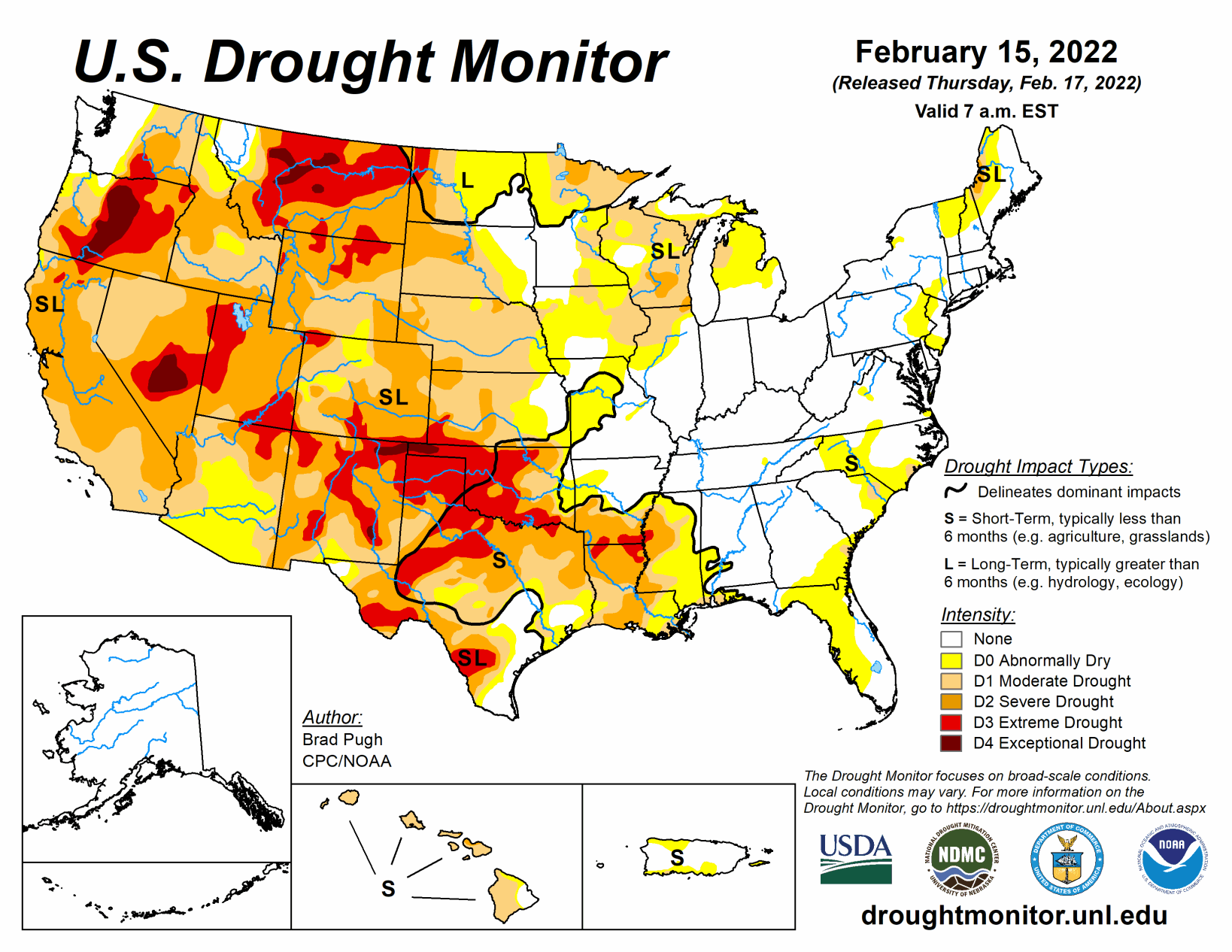
A broad area of surface high pressure resulted in little to no precipitation throughout the contiguous U.S. from Feb. 8 to 14. During this 7-day period, the most significant precipitation (more than 0.5 inch, liquid equivalent) was limited to the Cascades, Upper Mississippi Valley, northern New England, and the Florida Peninsula.
Following a wet December with beneficial snowfall, a persistent area of mid-level high pressure anchored near the West Coast led to drier-than-normal conditions across the western U.S. since early January. During the second week of February, above-normal temperatures prevailed throughout the West and much of the Great Plains. Drier weather returned to Puerto Rico by mid-February, while enhanced trade wind showers resumed across the eastern side of Hawaii’s Big Island.
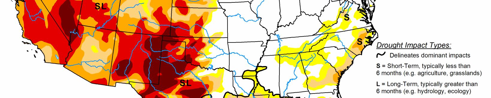
South
Based on 90-day SPI values and soil moisture indicators, a 1-category degradation was made to parts of Arkansas and adjacent northwest Mississippi. Impacts related to these worsening drought conditions include dry ponds and continued high fire danger. The previous week’s D2 areas in southwest Mississippi and adjacent Louisiana were merged and slightly expanded eastward, consistent with SPoRT soil moisture percentiles, 28-day average streamflows, and 90-day SPI values. Precipitation deficits of more than 8 inches are observed during the past 90 days across a broad area of the Lower Mississippi Valley.
An expansion of extreme drought (D3) was made across north-central Oklahoma, based on 90-day SPI and worsening soil moisture indicators. Persistent dryness along with periods of above normal temperatures and enhanced winds this winter prompted an expansion of severe to extreme drought (D2 to D3 ) across the middle Rio Grande Valley. Despite a dry week, a reassessment of SPI values at various time scales and soil moisture indicators supported a 1-category improvement from moderate drought (D1) to abnormal dryness (D0) across the southern Edwards Plateau. According to the USDA’s National Agricultural Statistics Service, 77 percent of the topsoil moisture was rated as poor to very poor across Texas as of February 13. Nearly two-thirds of oats, winter wheat, and rangeland and pastures were rated in poor to very poor condition.
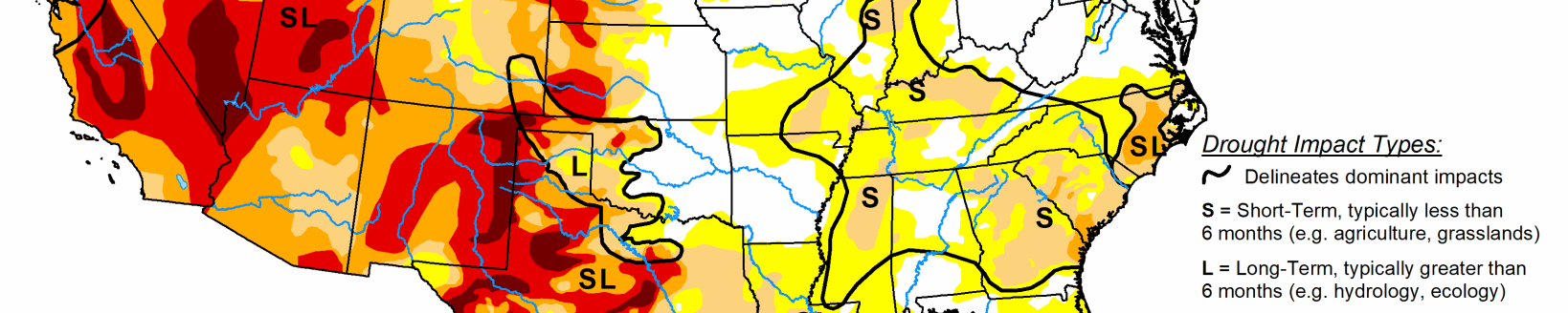
Midwest
Increasing 90-day precipitation deficits and consistent with worsening 90 to 120-day SPI values supported an expansion of moderate drought (D1) across eastern Iowa and adjacent areas of northern Illinois and southwest Wisconsin. An increase in the coverage of severe drought (D2) was necessary across southern Wisconsin based on 90 to 120-day SPIs. To be consistent with SPIs at various time scales throughout the Great Lakes, D1 was added to parts of southwest Lower Michigan.
High Plains
Moderate drought (D1) was degraded to severe drought (D2) across central Kansas and merged with ongoing D2 in southwest Kansas, based on 120-day SPI and soil moisture indicators. Since a 1-category degradation was made the previous week across northern Kansas and eastern Nebraska, these areas remained status quo this week given the time of year when worsening conditions are slower to be realized in terms of impacts.
Farther to the north, recent dryness with a lack of snow cover and above normal temperatures resulted in an increase of abnormal dryness (D0) and moderate drought (D1) across northern Nebraska and South Dakota. The updated depiction across the northern to central Great Plains follows closely the 30 to 90-day SPI and soil moisture indicators. Also, the SPI dating back 24 months was also weighed. Drought impacts for South Dakota include many days of high fire danger which is unusual during the winter, low stock ponds, and adverse conditions for recreational snowmobiling. Farther to the north across northern and eastern North Dakota, SPIs at various time scales supported a 1-category improvement. Recent snowfall (6 to 12 inches) and 6-month SPIs prompted a 1-category improvement to the Denver/Boulder metro areas, while 1-category degradations were made to parts of western and southern Colorado based on longer-term SPIs and current snowpack.
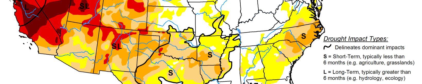
West
An expansion of extreme (D3) drought was made to parts of south-central Montana, based on SPI and EDDI at various time scales and soil moisture indicators. Although only light precipitation (less than 0.25 inch liquid equivalent) was observed in northeast Montana, a small area was improved from D3 to D2 due to a reassessment of indicators such as SPI values. Continued improvement of long-term SPI supported a slight reduction of D4 in northwest Montana. Severe (D2) drought was increased slightly in coverage across southwest Utah, as a result of low streamflows (below the 10th percentile) and 30-day SPI. 12-month SPEI along with worsening soil moisture indicators and 28-day average streamflows supported a 1-category degradation across parts of Oregon and adjacent areas of northwest California.
Related Articles