Some drought relief felt in parts of US
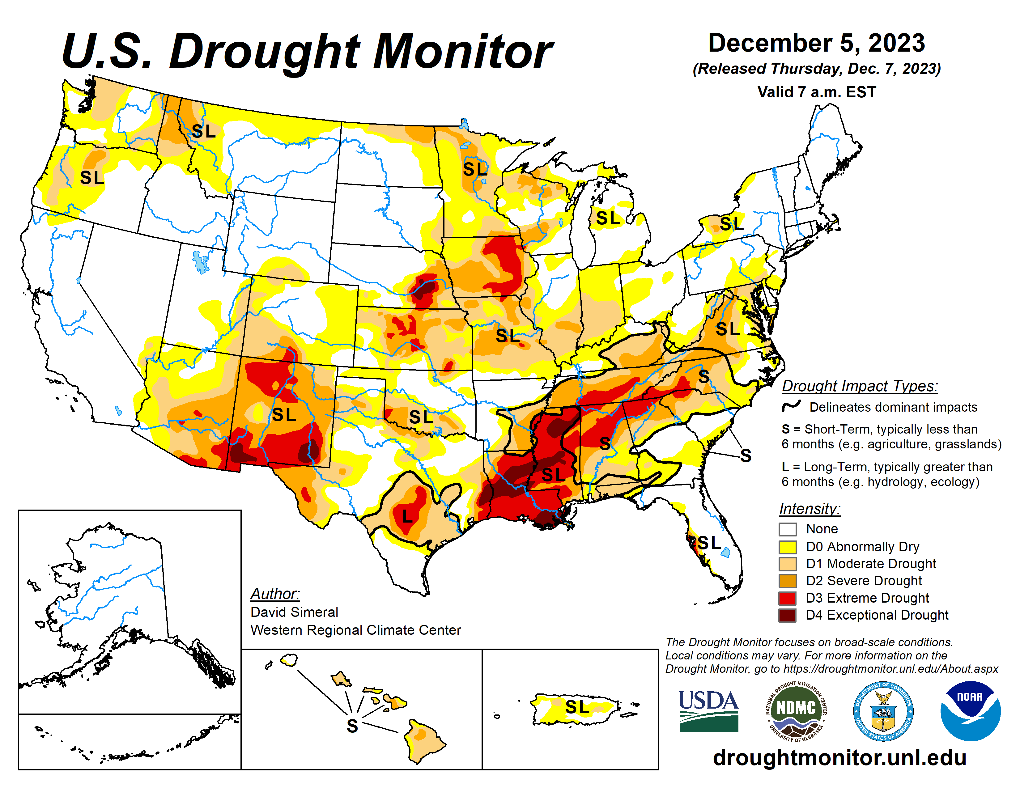
This U.S. Drought Monitor week saw continued improvements on the map in drought-affected areas of the South, Southeast, and Pacific Northwest.
Heavy rains over the weekend impacted areas of the Mid-South, and Gulf Coast states with isolated locations in southern Louisiana and the Florida Panhandle receiving up to 7-inch accumulations.
A series of atmospheric rivers delivered heavy rainfall to western Oregon and Washington as well as significant mountain snow to the higher elevations of the Olympic Peninsula, Cascade Range, and the Blue Mountains of northeastern Oregon. Inland, higher elevations in central Idaho and northwestern Montana ranges, Northern Great Basin ranges, the Tetons and Wind River ranges in northwestern Wyoming, the Wasatch Range in northern Utah, and the Colorado Rockies all received significant snowfall accumulations that helped to boost snowpack levels closer to normal to above normal levels.
The U.S. Drought Monitor is jointly produced by the National Drought Mitigation Center at the University of Nebraska-Lincoln, the U.S. Department of Agriculture and the National Oceanic Atmospheric Administration. (Map courtesy of NDMC.)
South
Locally very heavy rainfall (up to 9 inches) was observed along the Gulf Coast regions of Texas, Louisiana, and Mississippi leading to one-category improvements in areas experiencing severe drought conditions.
In Texas, areas of Extreme Drought (D3) expanded on the Edwards Plateau and South Central due to a combination of factors including long-term precipitation deficits and poor hydrologic conditions (streamflows, groundwater, and reservoir storage). Statewide reservoir conditions in Texas were at 68% full, with some poor conditions being reported including in the San Angelo area reservoirs which were at 22.9% full, according to Water Data for Texas.
Recent precipitation events led to some minor improvements in areas of Moderate Drought (D1) and Severe Drought (D2) in northeastern Oklahoma while areas of Abnormally Dry (D0) were added in the Panhandle region. According to the Oklahoma Mesonet, the Panhandle region has gone 64 consecutive days with less than 0.25 inches of rainfall.
Midwest
For the week, some light precipitation accumulations (generally < 1 inch liquid) were observed in the region including some light snowfall, mixed rain-snow, and rain.
The drought situation across part of the region has been complicated by a mix of wet/dry signals in the drought indicators during the past 30-90-day period. In terms of hydrologic conditions, the U.S. Geological Survey is reporting numerous creeks and rivers with 14-day average flows below the 10th percentile in Iowa, Missouri, Illinois, Indiana, Michigan, and Ohio.
High Plains
On this week’s map, some widespread one-category improvements were made across southeastern Kansas in response to precipitation during the past 30 to 60 days. According to the USGS, streamflow levels in the southeastern and east-central part of the state are normal to above normal.
Conversely, numerous stream gauges are reporting much below-normal flows (< 10th percentile) in the central part of the state. In the Dakotas, conditions on the map remained status quo.
In terms of snowpack conditions, the NWS NOHRSC reports the Upper Midwest Region (which includes the Dakotas, eastern Montana, and northeastern Wyoming) is currently 4.8% covered by snow with a maximum depth of 10 inches. Average temperatures for the week were generally above normal (2 to 10+ degrees F) with the greatest departures observed in the Dakotas.
West
Improvements were made across areas of the Southwest and Pacific Northwest including New Mexico, Oregon, and Montana. In northern New Mexico, areas of Extreme Drought (D3) were reduced in response to recent precipitation (past 14-day period) including high-elevation snowfall in the Nacimiento and Sangre de Cristo ranges.
According to the NRCS SNOTEL network, sub-basin (8-digit HUCs) percent of median SWE levels were above normal in several New Mexico sub-basins including: Rio Grande-Santa Fe 116%, Jemez 170%, Chaco 161%, Rio Puerco 212%, and Upper Gila 192%. For the week, average temperatures across the region were generally above normal (2 to 8 degrees Celsius) with the greatest positive departures observed in central portions of Oregon and Idaho and across the eastern two-thirds of Montana.
Looking ahead
The NWS Weather Prediction Center 7-Day Quantitative Precipitation Forecast calls for 1 to 2+ inch accumulations (liquid) are expected in northwestern Montana. In the Intermountain West, accumulations around an inch are expected in areas of the northern Great Basin, and the Rockies (central and northern).
The NWS Climate Prediction Center (CPC) 6-10 Day Outlooks call for a moderate-to-high probability of above-normal temperatures across the northern Plains. Conversely, temperatures are expected to be below normal across most of the Gulf Coast region, Texas, and eastern New Mexico. In terms of precipitation, below-normal precipitation is expected across most of the conterminous U.S. except for areas of Texas.
David Simeral is with the Western Regional Climate Center.
Related Articles


