Another round of moisture hits Plains states
A low pressure system developed over the central Plains in conjunction with an amplifying upper-level trough dipping into the northern Plains brought active weather across much of the central to eastern United States.
Warm and moist air from the Gulf of Mexico moved northward ahead of the developing low pressure, producing widespread moderate to heavy rainfall from Texas to Louisiana. A cold air mass from Canada dipped into the northern portions of the U.S. brought blizzard conditions to portions of the central Plains and Upper Midwest. Temperatures were above-normal across most of the U.S., by as much as 20-plus degrees Fahrenheit above average in parts of the Upper Midwest and northern Plains.
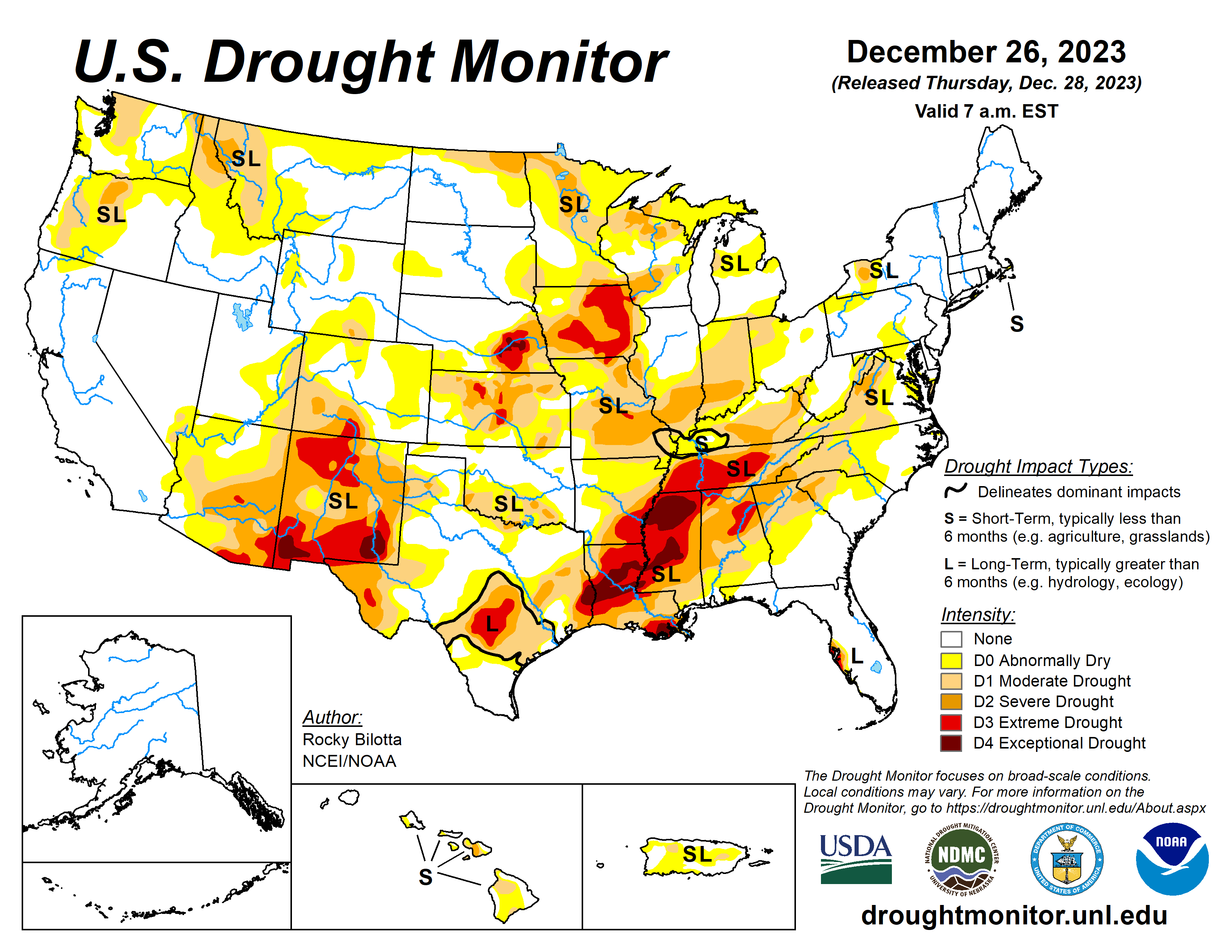
The most widespread improvements were made to parts of central Texas, eastern Nebraska, eastern Kansas and southern Louisiana. Dry conditions continued across the eastern portions of the southern region, with degradations occurring across much of Mississippi and into Arkansas and Tennessee.
Drought and abnormal dryness were also expanded or intensified in portions of the northern Rockies and in parts southern Illinois, southern Texas and in the Southeast.
The U.S. Drought Monitor is jointly produced by the National Drought Mitigation Center at the University of Nebraska-Lincoln, the U.S. Department of Agriculture and the National Oceanic Atmospheric Administration. (Map courtesy of NDMC.)
High Plains
Heavy precipitation fell over much of eastern portions of the region, where rainfall totals were greater than 600 percent of normal and ranged between 1 to 4 inches this past week.
Exceptional drought (D4) was improved in eastern Nebraska, while extreme drought (D3) was improved in eastern portions of Nebraska and Kansas where precipitation totals were up to 3 inches above normal for the week.
Above-normal precipitation also led to improvements to severe drought (D2) and moderate drought (D1) over parts of eastern Kansas and northeast Nebraska. Abnormal dryness (D0) was improved along parts of the eastern border of the High Plains and in portions of western Kansas and eastern Colorado.
Conversely, dry conditions persisted in portions of eastern Colorado and Wyoming where precipitation remains below normal. Deteriorating conditions shown in short-term SPI/SPEI, streamflow, soil moisture and snow water equivalent (SWE) data justified degradations across these states. Abnormal dryness was expanded in parts of northern Colorado and in eastern and southern Wyoming. Abnormal dryness was introduced in north-central and northeast Wyoming.
South
Dry conditions continued across the eastern portions of the southern region while heavy precipitation fell across much of Oklahoma and over parts of central and eastern Texas. Large portions of eastern Texas and Oklahoma received between 2 inches to 5 inches of rainfall (300 to 600% above normal. The result was improvement of exceptional drought (D4) in eastern Texas. Extreme drought (D3) was removed from northeast Oklahoma and improved in parts of central and eastern Texas.
Improvements were also made to moderate drought (D1) to severe drought (D2) conditions, along with abnormal dryness (D0), in this part of the region. Heavy rain was reported (2 to 4 inches of rainfall) over parts of southeastern Louisiana resulting in the 1-category improvement across the area. Conversely, conditions continued to deteriorate in parts of Mississippi, Arkansas and Tennessee, where precipitation totals were 2 to 4 inches below normal this month.
Exceptional drought was expanded in parts of central and northern Mississippi and was introduced into eastern Arkansas, while extreme drought was expanded into the northern portions of Tennessee and in parts of Mississippi and Arkansas. The expansion and intensification of drought categories were based on short-term SPI/SPEI, NDMC’s short-term blend, streamflow and soil moisture data.
Midwest
Average temperatures were well above normal across the Midwest, with temperatures ranging between 10 to 25 degrees above normal this past week. Much of the region also observed above-normal precipitation especially along the western portions of the Midwest. The heaviest amounts totaled between 2 to 4 inches of rainfall and ranged between 1 to 3 inches (300% to 600%) above normal.
Above-normal precipitation helped to alleviate longer-term precipitation deficits and improved soil moisture and streamflow impacts, resulting in improvements to abnormal dryness (D0) and all drought categories. A broad 1-category improvement was made across western Missouri, while additional improvements were made in parts of western Minnesota, northwest Iowa and western Illinois.
West
Much of the West remained as status quo this week. Precipitation fell across much of the region, which was enough to prevent further degradation but not enough to warrant large improvements. Heavier precipitation fell across the southern portions of Arizona and New Mexico, where rain totals were greater than 600% above normal.
These beneficial rains, along with precipitation percentiles and short-term SPI/SPEI, soil moisture and streamflow data, resulted in abnormal dryness (D0) and moderate (D1) to extreme (D3) drought improvements along the southern border. Portions of La Paz and Yuma counties reported weekly rainfall totals up to 6 inches above normal. Conditions remained dry in northern parts of the Rockies, resulting in further deterioration across western Montana and eastern Idaho.
Moderate drought and abnormal dryness were expanded in these areas based on short-term SPI/SPEI data, low snow water equivalent (SWE) percentiles and precipitation and soil moisture deficits. As for temperature, much of the region was above normal with well-above-normal temperatures were observed in parts of northeast Montana which were greater than 10 degrees F above normal.
Looking ahead
During Dec. 26 to 30, an initial Plains/Midwest upper low will work to establish the eastern upper trough, and an associated surface system will spread rainfall of varying intensity over the East early-mid week along with the potential for lingering snow over the north-central Plains.
The Climate Prediction Center’s six- to 10-day outlook Dec. 31 to Jan. 4 favors above-normal precipitation from California to Alabama, and across much of Alaska. Below-normal precipitation is most likely from the northern Plains to the Northeast, in portions of the Northwest and Hawaii, and in parts of southern Florida and Alaska Panhandle.
Above-normal temperatures over much of the West, along the northern tier and in parts of the southern Plains, as well as Alaska and western islands of Hawaii.
Rocky Bilotta is with the National Oceanic and Atmospheric Administration and National Centers for Environmental Information.


