Cold weather and moisture defined January
The synoptic pattern over the last week favored continued precipitation over the coastal areas of the Pacific Northwest and very widespread and heavy precipitation in the South and Southeast and into the Midwest.
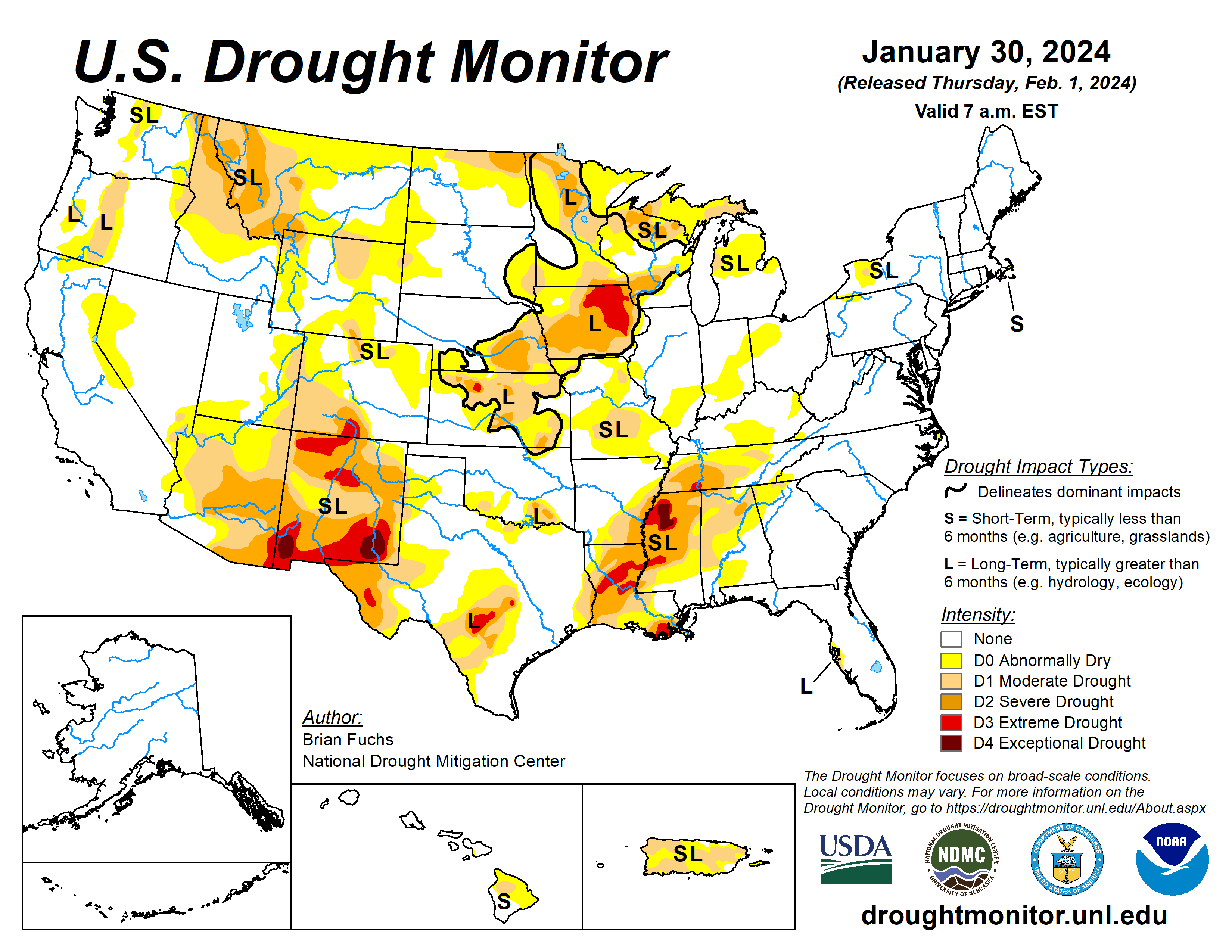
Some areas of east Texas, Louisiana and Mississippi recorded over 8 inches of rain for the week. Dryness dominated the central to high Plains and most of the rest of the West as well as the Atlantic Coast into south Florida.
After a very strong cold snap in previous weeks, temperatures this week were warmer than normal over much of the United States, with the upper Midwest having the greatest departures of 15 to 20 degrees Fahrenheit above normal in Minnesota and northern Wisconsin. Across the plains of Wyoming and Montana and into the northern Rocky Mountains, there is building concern over the lack of snow this current water year and snow drought concerns are also prevalent in portions of the High Plains and upper Midwest.
The U.S. Drought Monitor is jointly produced by the National Drought Mitigation Center at the University of Nebraska-Lincoln, the U.S. Department of Agriculture and the National Oceanic Atmospheric Administration. (Map courtesy of NDMC.)
Temperatures were cooler than normal over central Oklahoma into northern Texas where departures were 1 to 3 degrees below normal.
Most of the rest of the region was near normal to 3 to 6 degrees above normal, with the greatest departures over Mississippi where it was 9 to 12 degrees above normal. It was a very wet week for the region.
Some areas of east Texas and into Arkansas recorded over 800% of normal precipitation for the week and almost all areas were 200-400% of normal precipitation. Widespread improvements to the overall drought status were made over most of Arkansas, Tennessee, Mississippi, Louisiana, and east Texas where a full category improvement in drought intensity status was made.
Some areas were investigated for multiple categories of improvement but with some of the long-term issues still showing up, most improvements were limited to a single reduction in intensity. Southern Oklahoma and north Texas had targeted improvements to the severe and moderate drought as well as the abnormally dry conditions. Portions of west Texas continued to be dry and may need to see drought intensification if the pattern doesn’t change.
Midwest
Temperatures were warmer than normal over most of the region outside of Missouri where they were closer to normal for the week. Northern Minnesota into northern Wisconsin recorded temperatures that were 18 to 24 degrees above normal. Outside of western Iowa, Minnesota, northern Wisconsin and northern Michigan, almost all areas saw 200 to 400% of normal precipitation for the week.
Many reports were coming in that in areas where snow insulated the ground during the previous cold outbreak, soils were actually not frozen and moisture was making its way into the soil profile.
There was also less runoff associated with melting this week than there would have been if the soils were frozen. Most drought areas saw a full category of improvement this week in Missouri, Illinois, Indiana and Kentucky. Abnormally dry conditions were improved in Ohio while extreme and severe drought were improved in portions of central and southern Iowa.
High Plains
Most of the region was dry this week, with only portions of central Colorado, far southwest Kansas, and northern North Dakota recording normal to above-normal precipitation. Temperatures were near normal over much of Kansas and central Nebraska and were 5 to 10 degrees above normal for most of the rest of the region. Most of the region did not see any changes to the drought status.
Moderate drought was introduced over portions of western South Dakota and central Wyoming due to the ongoing dry winter and lack of snow. Abnormally dry conditions were improved in central Colorado based on the short-term improvements being observed there.
West
Areas along the coast and inland and into the Southwest recorded above-normal precipitation this week while much of the central to northern Rocky Mountains were dry.
The entire West was near to above normal for temperatures with the greatest departures over Montana, Wyoming, Utah and Idaho, where some areas were 10-15 degrees above normal for the week. This same area has been impacted by snow drought this current water year and there are developing concerns about water availability heading into the spring and summer as we approach February.
Severe drought was introduced into more of southern and central Montana and into northwest Wyoming.
Areas of southern Arizona and southern New Mexico had improvements where extreme drought was removed from much of southern Arizona and reduced in southern New Mexico with additional improvements to moderate and severe drought.
Looking ahead
Over the next five to seven days, an active pattern is anticipated to remain over the South and Southeast with another week of widespread precipitation from east Texas to the Carolinas. Some precipitation is anticipated over the central Plains while a wetter pattern is anticipated over most of the West, with the greatest precipitation along the California coast.
Temperatures during this period are anticipated to impact the Plains, Midwest and portions of the South. The greatest departures of above-normal temperatures are anticipated in the upper Midwest and northern Plains with departures of 20 to 25 degrees above normal.
The six- to 10-day outlooks show above-normal chances for warmer-than-normal temperatures over much of the country east of the Rocky Mountains with the greatest probability over the Great Lakes region and upper Midwest. The best chances for cooler-than-normal temperatures will be over the West. Much of the western half of the U.S. will have high probabilities of above-normal precipitation with the greatest chances over the Southwest.
Brian Fuchs is with National Drought Mitigation Center.
Related Articles


