Heavy rains, snow strike the West

A strong Pacific storm system brought flooding rains to California and heavy snow to the mountain ranges of northern California and the Sierra Nevada in the past week.
Parts of the state saw nearly a foot of rain from this storm, breaking long-standing records. Moisture from this system also brought rain and snow to the Pacific Northwest and inland regions of the West.
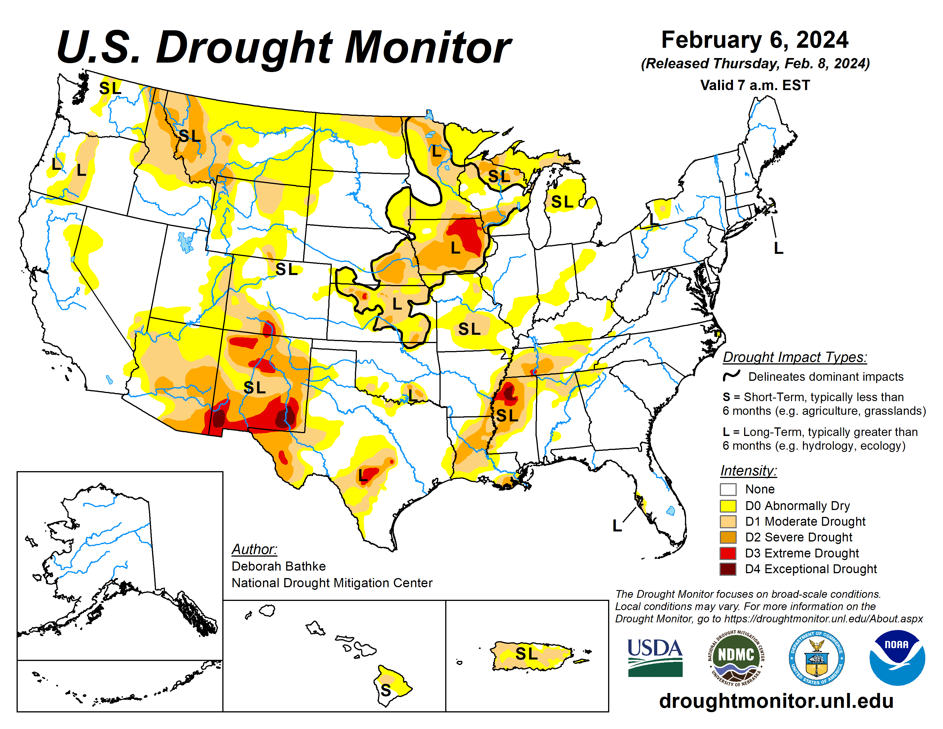
Most states in the region saw pockets of improvement despite the heaviest precipitation missing many of the West’s persistent drought areas. Another round of showers and thunderstorms passed through the South and Southeast. In the past two weeks, rainfall totals of more than 10 inches fell in parts of east Texas, Louisiana and Mississippi.
The excess rain brought one and two category improvements to drought. The Northern Plains, Upper Midwest, and Northeast stayed relatively dry, with well above normal temperatures last week. Concerns continue to grow over the lack of snow this season.
The U.S. Drought Monitor is jointly produced by the National Drought Mitigation Center at the University of Nebraska-Lincoln, the U.S. Department of Agriculture and the National Oceanic Atmospheric Administration. (Map courtesy of NDMC.)
South
Another round of wet weather brought more than 3 inches of rain to parts of Texas, Louisiana and Mississippi. Totals less than 0.25 inches fell in parts of Tennessee and Texas. The continued wet weather left parts of Alabama with 200% to more than 400% of normal rainfall for the last two weeks.
Much of the state saw 1- and 2-category improvements to drought conditions. While the drought developed rapidly over the summer, improvements are slower to happen. Rainfall deficits of more than 10 inches over the last six months remain over parts of Louisiana and Mississippi. Streamflow, groundwater levels, and deeper soil moisture also remain historically low for this time of year. The fact that drought signals are still present shows how dry it was during earlier months.
Midwest
High temperatures averaged about 6 to more than 20 degrees above normal breaking records across the region. Precipitation of less than 0.25 inches fell across the eastern half of the region.
Southern Missouri recorded totals of 1 to 2 inches. The rest of the Midwest was dry. After last week’s improvements, relatively few changes were made to the map this week.
Abnormal dryness (D0) expanded in northeast Minnesota where state teams report a lack of snow cover, unusual for this time of year. Moderate drought (D1) improved in southwest Minnesota, one of the few places in the state to record above normal precipitation for the month of January.
High Plains
High temperatures averaged about 8 to more than 20 degrees Fahrenheit above normal. Precipitation of less than 0.25 inches fell across much of the Dakotas, eastern Nebraska, and southwest Kansas. The rest of the region recorded totals ranging from about 0.25 inches to just over 1 inch.
Moderate drought (D1) improved in eastern South Dakota in response to above normal precipitation during the month of January. South-central Nebraska and northern and central Kansas also saw 1-category improvements to long-term drought areas. While short-term moisture deficits have largely been eliminated, a dry signal remains at timescales longer than about 6 months.
Precipitation deficits of nearly 10 inches over the last year remain in drought areas in these states and impacts to deeper soil moisture levels and groundwater continue to linger.
West
Outside of California, precipitation mostly totaled less than 3 inches. Pockets of improvements occurred in Idaho and western Montana, where recent precipitation has helped reduce drought signals in the short and longer terms. Central Arizona, the Four Corners region, and Colorado also saw improvements. A lack of snow in eastern Montana and western North Dakota led to the expansion of abnormal dryness (D0).
Looking ahead
The National Weather Service Weather Prediction Center forecast (valid Feb. 7 to 10) calls for another round of rainfall to sweep across California and into the Desert Southwest.
High elevation snow is expected over mountains in the West with a wintry mix (freezing rain, sleet, and snow) over the northern Plains and upper Midwest. Heading into the weekend, the extended forecast (valid Feb. 10 to 14) calls for a band of heavy rain across the South and Southeast. High temperatures are expected remain above average across central and eastern parts of the country.
The Climate Prediction Center’s 6-to 10-day outlook (valid Feb. 13 to 17) calls for an increased probability that observed temperatures, averaged over this seven-day period, will be above normal across the Upper Midwest, the West Coast, and Alaska. Temperatures across the remaining parts of the country are expected to be near to below normal.The pattern of increased precipitation across California and the southern tier of the continental U.S. (CONUS) is expected to continue, while much of the remaining CONUS, eastern Alaska, and the Big Island of Hawaii are expected to have below or near-normal precipitation.
Deborah Bathke is with National Drought Mitigation Center.


