Dry weather pattern hits the Plains
An atmospheric river of Pacific storm systems slammed parts of the West Coast with heavy precipitation the week of Feb. 14 to 20. However, the weather systems dried out as they crossed the western mountains, then produced anemic precipitation amounts east of the Rockies.
Parts of the Midwest and Northeast received limited precipitation amounts from passing cold fronts, and heavier rain fell along the Texas coast and across Florida from another frontal system. Much of the country east of the Rockies, as well as the southwestern United States, received little to no precipitation.
The weather systems distorted the upper-level circulation over the contiguous U.S., which otherwise consisted of a high-pressure ridge over western North America and a low-pressure trough over the east.
The end result of this distortion was a temperature anomaly pattern that consisted of warmer-than-normal weekly temperatures in the Upper Midwest. Also in parts of the interior West, and below-normal temperatures in the Pacific Northwest, Rockies, and southern tier states, with near-normal temperatures elsewhere.
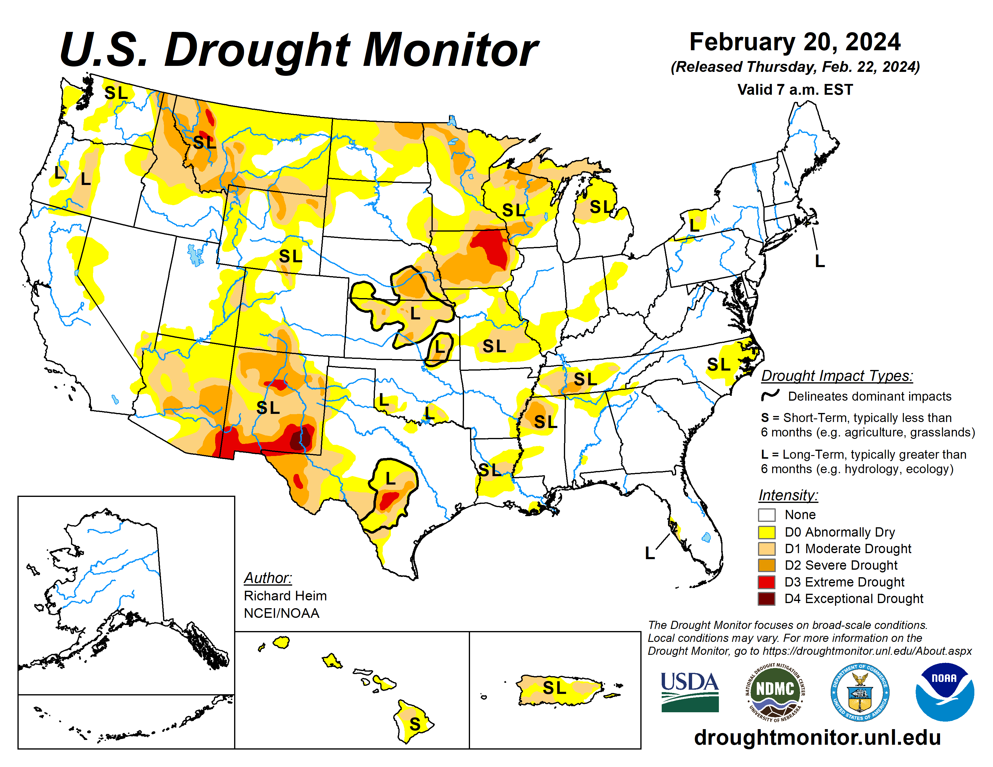
Drought or abnormal dryness expanded or intensified this week in parts of the northern Rockies, northern Plains, Upper Midwest, Middle Mississippi Valley, and Rio Grande Valley. Drought or abnormal dryness contracted or reduced in intensity in parts of the Four Corners states and Lower Mississippi Valley.
The U.S. Drought Monitor is jointly produced by the National Drought Mitigation Center at the University of Nebraska-Lincoln, the U.S. Department of Agriculture and the National Oceanic Atmospheric Administration. (Map courtesy of NDMC.)
South
Half an inch or more of precipitation fell across parts of the Texas coast, and there were a few areas of up to half an inch of precipitation in Arkansas and Tennessee, but otherwise the South region received no precipitation.
D0 and D1 were expanded in west Texas along the Rio Grande Valley to reflect dry conditions over the last seven days to three months, low streams, drying soils, and stressed vegetation indicated by satellite. D0 was contracted in South Texas and D1 contracted slightly in central Texas (Bell County).
No change was made in Oklahoma, where reservoir levels remain historically low. A reassessment of conditions resulted in the removal of the D3 (extreme drought) and trimming of D2 in northwest Mississippi, trimming of D0-D1 in Arkansas, Louisiana, and Mississippi, and trimming of D0 in Tennessee.
Precipitation is near to above normal in these areas for the last one to four months, streamflow is near to above normal, and surface soil moisture has been recharged. In Louisiana, stock ponds mostly refilled. The remaining D0-D2 is sufficient to reflect the longer-term dryness which shows up most severely at the six- to 12-month period.
Midwest
A few areas received half an inch of precipitation, but most of the Midwest region received only a couple tenths of an inch. Dry conditions over the past one to six months prompted the expansion of D0-D2 in Michigan and Wisconsin and D1 in southeast and northeast Minnesota.
The lack of snow (“snow drought”) in Minnesota has had a sizable impact on winter recreation. D0 expanded slightly in northwest Iowa. D0 expanded in southern Illinois where the last one to three months have been dry, streamflow and water table levels are below normal, and reports of some field fires have been received.
In eastern Missouri, D0 and D1 expanded to reflect lowering streams, drying soils, and three- to nine-month precipitation deficits. Temperatures were 6 to 9 degrees Fahrenheit above normal in northern parts of the region.
The Midwest has experienced unusually warmer-than-normal temperatures during the past one to two months, with the last month averaging 6 degrees above normal along the Ohio Valley to over 15 degrees above normal in Minnesota. Since this is winter, vegetation is dormant and evapotranspiration is minimal.
But in the weeks ahead, if the anomalous warmth persists as the region transitions into spring, evapotranspiration will increase, soils will dry, and the effects of the moisture stress, if rain isn’t sufficient, will need to be reflected in the USDM depiction.
High Plains
Half an inch to locally 2 inches of precipitation fell this week over the Colorado mountains into adjacent Wyoming, and over western Wyoming. A band of precipitation extended across South Dakota, with locally up to half an inch falling.
Otherwise, the High Plains region received little to no precipitation. D0 was expanded in the Dakotas, and D1 expanded in North Dakota, where the last 3 months have been dry and the lack of snow cover has exposed bare ground.
D0 and D1 were adjusted in north central and southwest Colorado where recent precipitation resulted in local improvements and continued dryness caused local expansion. D2 was introduced in north central and northeastern Wyoming.
West
Half an inch of precipitation fell across southern parts of the Pacific Northwest inland to the Rockies and a few areas to the north, with up to 2 inches falling from the Great Salt Lake area to Yellowstone National Park.
Another area of 1 to 2 inches of precipitation occurred over the Colorado Rockies into adjacent Wyoming.
While this week was dry across New Mexico, precipitation from the last two weeks to three months prompted the elimination of the D4 in southwestern New Mexico and the northwest D2, and contraction of the D3 in north central and D2 in southwestern parts of the state.
In northern parts of the West, precipitation for the water year to date (Oct. 1, 2023 to Feb. 18, 2024) has been largely below normal and the winter snowpack is significantly below normal.
Parts of the northern Rockies have record low SWE values, according to SNOTEL data. D0 expanded in parts of Idaho, Oregon, and Washington; spots of severe drought (D2) were added in north central and northeast Wyoming. D2 was expanded and new D3 added in parts of Montana, especially the western and southern mountains. In that region the past three to four months have been dry and SWE values are record low.
Looking ahead
In the two days since the Tuesday valid time of this USDM, Pacific moisture continued to move across parts of the West, with little precipitation falling east of the Rockies. For Feb. 22 to 27, one weather system will move across the eastern CONUS, while another moves into the West by the end of the period.
The first is forecast to drop 0.5 to 1.5 inches of precipitation across the Tennessee Valley and southern Appalachians northward to the southern Great Lakes and central Appalachians, with half of an inch or less over the Northeast and even less over the Southeast.
The second is expected to bring an inch or more of precipitation to the central and northern Rockies, coastal ranges of the Pacific Northwest, and Sierra Nevada, with up to 3 or 4 inches in the Washington Cascades.
Other areas of the West are forecast to receive less than half an inch of precipitation, with little to no precipitation over the Southwest.
For the Great Plains to Mississippi Valley, little to no precipitation is predicted. Temperatures are expected to be warmer than normal, with the warmest anomalies across the Plains and Mississippi Valley due to upper-level ridging.
For much of the next two weeks, the atmospheric circulation is expected to consist of an upper-level trough over the western CONUS and a ridge over the eastern two-thirds of the country, with Pacific weather systems migrating through the trough/ridge pattern.
The Climate Prediction Center’s six- to10-day outlook (valid Feb. 27 to March 2) and eight- to 14-day outlook (valid Feb. 29 to March 6) favor a fairly stable pattern of warmer-than-normal temperatures from the Plains to East Coast. It calls for cooler-than-normal temperatures over the West and Alaska.
The outlook is for above-normal precipitation over much of the CONUS, especially along the West Coast and Great Lakes, with odds favoring near to below-normal precipitation across the Plains and over most of Alaska.
Richard Heim is with the National Oceanic and Atmospheric Administration and National Centers for Environmental Information.


