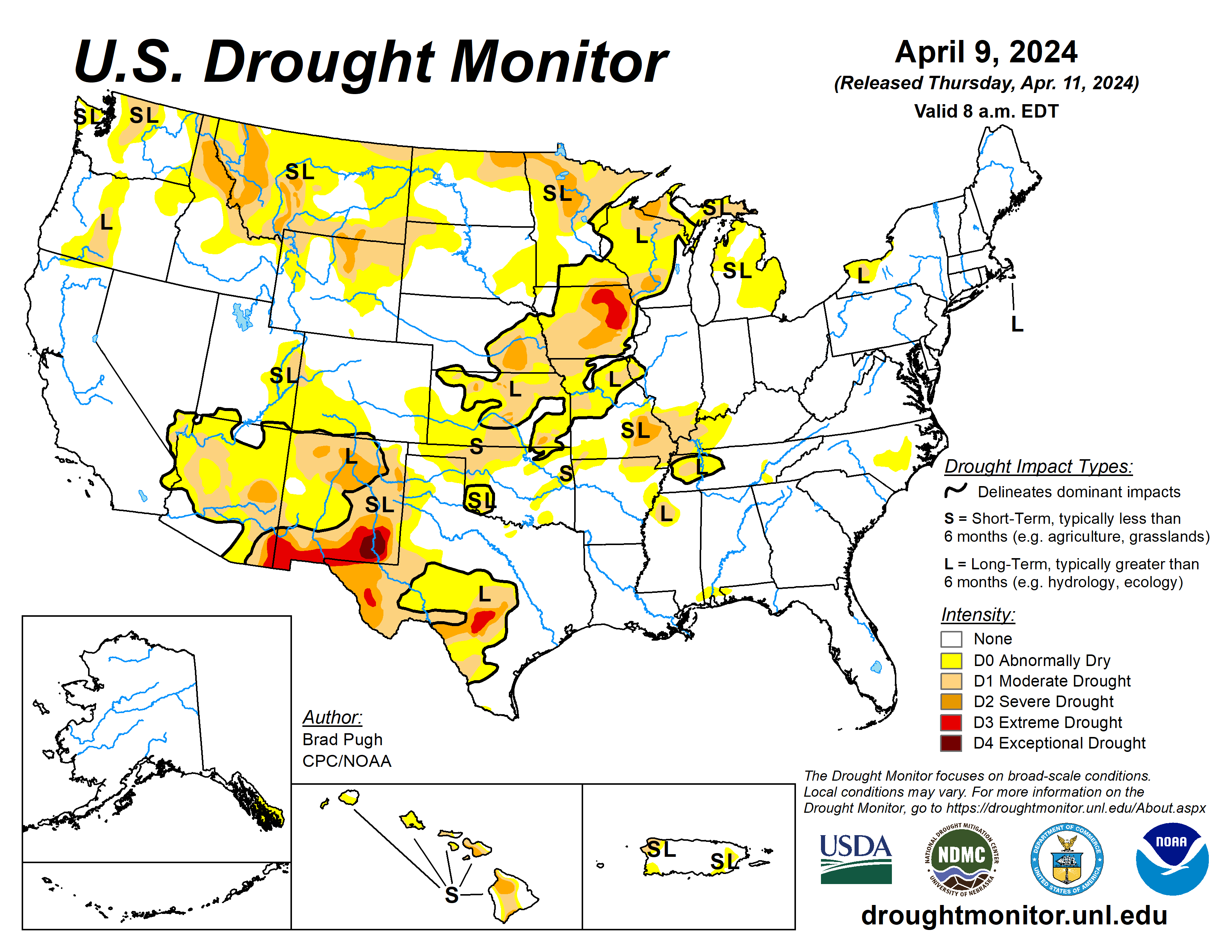
Following the El Nino winter and an active early spring pattern, drought coverage is at its lowest since the spring 2020.
A strengthening low pressure system and trailing cold front progressed east from the Mississippi Valley to the East Coast at the beginning of April. This storm brought heavy snow (6 to 18 inches, locally more than 2 feet) to the Upper Peninsula of Michigan, Wisconsin, and northern New England. The recent precipitation (rain and snow) during the past few weeks continued to ease drought conditions across the Upper Midwest.
From April 5 to 7, a strong storm system tracked east from the Rockies to the Great Plains. Heavy snowfall (6 to 12 inches, locally more) occurred across parts of Idaho, Montana, and Wyoming. Total precipitation amounts of 1 to 2 inches, liquid equivalent, resulted in drought improvement from the north-central Rockies to western South Dakota.
Drought continued to develop or intensify across parts of the southern Great Plains and lower Ohio Valley along with Hawaii. Heavy rainfall across the South, occurring after 8 a.m. April 9, will be considered in the next U.S. Drought Monitor.
The U.S. Drought Monitor is jointly produced by the National Drought Mitigation Center at the University of Nebraska-Lincoln, the U.S. Department of Agriculture and the National Oceanic Atmospheric Administration. (Map courtesy of NDMC.)
South
Major drought relief, associated with El Nino, occurred this past winter across the lower Mississippi Valley. Precipitation from April 2-8 led to a small decrease in abnormal dryness and moderate drought to parts of this region.
A strengthening low pressure system on April 6 and 7 brought high winds and elevated wildfire danger to the southern Great Plains which dried out topsoil, especially across northwestern Oklahoma. The 30- to 90-day Standardised Preciptiation-Evapotranspiration Index along with the lack of vegetation green up supported an expansion of D0 and D1 across parts of Oklahoma. Northern Arkansas and northwestern Tennessee also had an increase in D0 and D1 coverage as short-term precipitation deficits became larger dating back to 60 days.
Midwest
On April 2, a swath of heavy precipitation (1 to 2 inches, liquid equivalent) was observed across eastern Iowa, northwestern Illinois, and parts of Wisconsin.
This recent precipitation along with considerations of long-term indicators supported a 1-category improvement to these areas. Moderate drought and abnormal dryness was reduced across the Upper Peninsula of Michigan along with the northern shore of Lake Superior in northeastern Minnesota as shorter term SPIs are either neutral or positive.
More precipitation overspread the Upper Midwest on April 6 and 7 which also supports the decreasing coverage and intensity of drought across this region since mid-March. Following frequent precipitation this past month, D1 coverage was nearly eliminated from southwestern Indiana.
Southern Missouri and western Kentucky continue to miss out on precipitation and based on 60-day SPI and National Drought Mitigation Center’s short-term blends, D0 and D1 were expanded for those areas. Following heavy precipitation during the first week of April, improvements were justified near to the north of St Louis.
High Plains
Widespread rain and snow (1 to 2 inches of precipitation, liquid equivalent) on April 7 led to a 1-category improvement across parts of northeastern Wyoming and western South Dakota.
Despite the recent heavy precipitation, 6-month SPI along with 28-day average streamflow support a continuation of moderate drought across the High Plains. Following another week of precipitation along with considerations of soil moisture and SPI values of neutral to positive, abnormal dryness (D0) coverage was reduced throughout the Dakotas.
A strengthening low pressure system on April 6 and 7 brought high winds to the Great Plains which dried out topsoil especially across Kansas and southeastern Colorado. A reassessment of SPIs at various time scales and given snow water equivalent is slightly above average, D1 coverage was reduced for southern Colorado.
West
As a low pressure system shifted inland, widespread precipitation (rain and high-elevation snow) overspread the West from April 3 to 6. Heavy precipitation (more than 1.5 inches, liquid equivalent) along with snow water equivalent amounts near average supported a 1-category improvement to western Idaho and northeastern Oregon.
Parts of western Montana also had a 1-category improvement due to a wet week and considerations such as SWE and SPIs at various time scales. The current depiction of moderate to severe drought across Idaho and western Montana lines up well with the 6 to 9-month SPI. On April 5 and 6, a major storm developed across the northern Rockies and high Plains with precipitation amounts exceeding 1.5 inches (liquid equivalent) across southern Montana.
Based on this heavy precipitation and lack of support from SPIs at various time scales, a 1-category improvement was made to this region. Neutral to positive SPIs at multiple time scales and SWE near to slightly above normal supported the removal of D0 (abnormal dryness) from western Nevada and adjacent areas of California.
Farther to the north, low snowpack resulted in a second week of D0 and D1 expansion across north-central and northeastern Washington. Although it was a mostly dry week for the Southwest, a reassessment of SPIs at various time scales led to targeted improvements for parts of New Mexico.
Looking ahead
From April 12 to 14, much drier weather is forecast throughout the eastern and central U.S. By April 14, another low pressure system is expected to track inland to the West with additional rain and high-elevation snow. Later on April 15, another round of wet weather is anticipated for the northern Great Plains and Midwest.
The Climate Prediction Center’s 6- to 10-day outlook (valid April 16 to 20) favors above-normal temperatures across the eastern and southern contiguous U.S. with below-normal temperatures most likely across the northern Great Plains, northern to central Rockies, and Pacific Northwest.
Increased above-normal precipitation probabilities are forecast for most of the eastern and central CONUS excluding Florida where below-normal precipitation is slightly favored. Below-normal precipitation is also more likely along the West Coast.
Brad Pugh is with the National Oceanic Atmospheric Administration and the Climate Prediction Center.


