A highly variable precipitation pattern was noted across the contiguous 48 states this past week, resulting in a significant number of changes in the Drought Monitor depiction.
Another week of heavy rain June 4 to 11 continued to ease drought and abnormal dryness in parts of the central and southern Plains, with excessive amounts resulting in 2-category improvements in portions of central Kansas. Moderate to heavy rainfall also brought improvements to portions of the middle and upper Mississippi Valley. Meanwhile, deficient rainfall caused abnormal dryness and drought to expand or intensify in parts of a few scattered areas across Texas, part of the central Rockies and the northern High Plains.
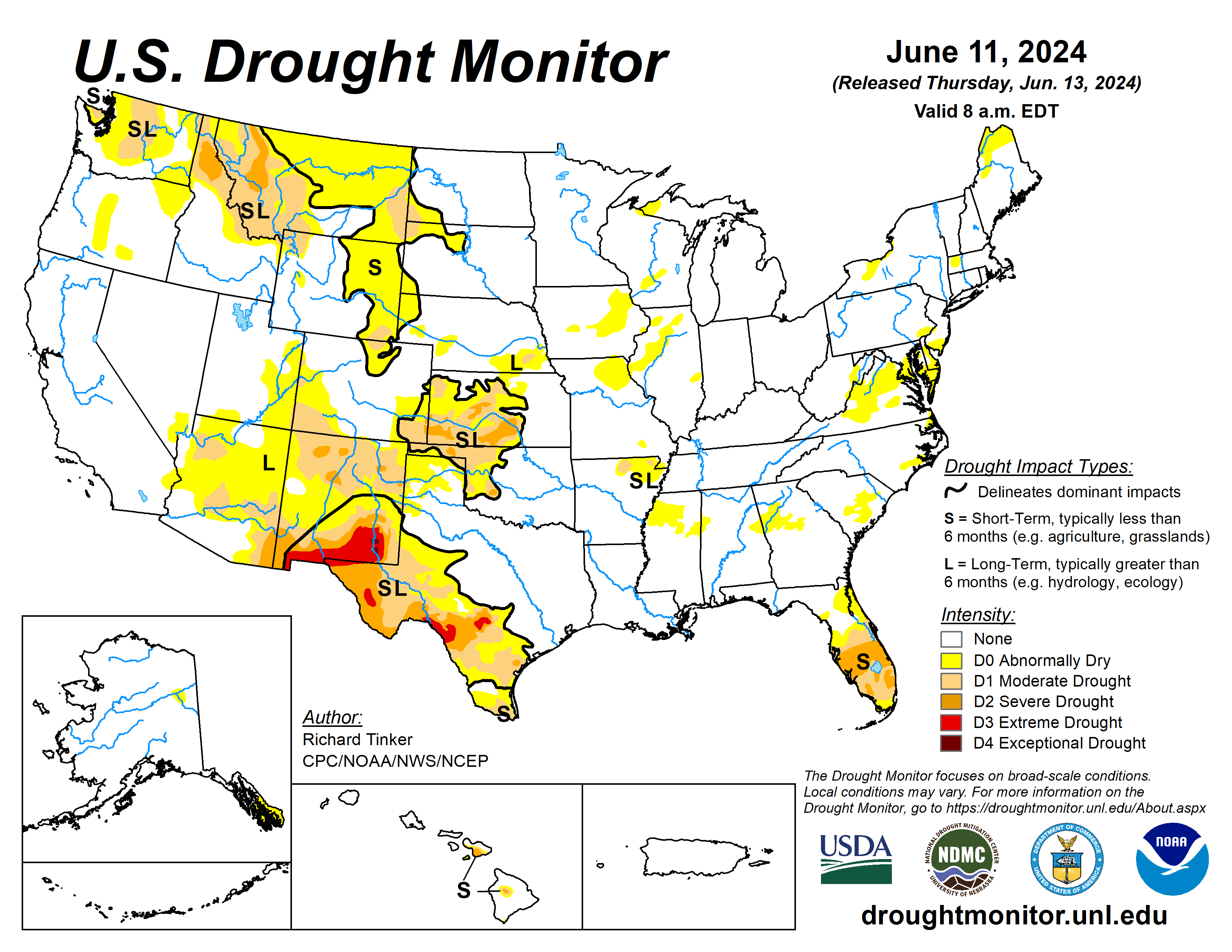
The U.S. Drought Monitor is jointly produced by the National Drought Mitigation Center at the University of Nebraska-Lincoln, the U.S. Department of Agriculture and the National Oceanic Atmospheric Administration. (Map courtesy of NDMC.)
South
Widespread dryness and drought continued to cover western Oklahoma, the western Texas Panhandle, and most other areas across southern and western Texas. Rainfall totals were generally unremarkable across western Oklahoma, keeping D0 to D2 conditions generally unchanged, save for a couple of small patches near the central part of the state. In contrast, rainfall was highly variable in the areas of Texas that have been affected by dryness and drought (D0 to D3) recently, leading to sizeable areas that felt both deterioration and improvement.
Most of the dry areas in the Texas Panhandle received at least moderate rain last week (1.5 inches or more), with several patches soaked by 3 to 5 inches of rain. As a result, improvement was introduced in many locations across this region. Farther south, moderate to locally heavy rains were observed in portions of the southern Edwards Plateau and southward through parts of Bandera, Medina, and Bexar Counties.
Totals of 1-2 inches were fairly common in this region, although a few swaths received more, up to 4 inches at a few isolated locations. Improvement was also introduced in significant parts of this region, although less broadly than farther north since heavier totals were not as widespread.
Moderate drought is restricted to a couple of patches in northeastern Arkansas, with abnormal dryness covering the remainder of northeastern Arkansas and a large part of northern Mississippi. Moderate rains brought limited improvement to portions of northeastern Arkansas this past week.
Midwest
A warm and wet spring eliminated much of the drought that had plagued western parts of this region, and with moderate to heavy rains in northern and southwestern parts of the Midwest. The wet weather also removed D0 from northern Minnesota, part of central and northeastern Iowa, and southern Missouri. Rainfall has not been so generous the past few weeks over west-central parts of the region, prompting some expansion of D0 conditions across northeastern Missouri.
Short-term moisture deficits are increasing in other nearby locations as well, most notably portions of Indiana and southeastern Iowa, and these areas will need to be monitored for the development of abnormal dryness in the next few weeks.
High Plains
Parts of the southern High Plains region were hit by heavy to excessive rains, bringing widespread improvement to the entrenched dryness and drought affecting much of Kansas and eastern Colorado. The heaviest amounts soaked a swath across central Kansas, with more scattered heavy rains observed farther north in Kansas and across eastern Colorado.
Between 5 and 8 inches fell on central Rice, eastern McPherson, central Marion, and much of Chase Counties in central Kansas, prompting some 2-category improvements there. D3 conditions were eliminated from the High Plains region, and severe drought is now limited to a few several-county south and west of the band where the heaviest rains fell last week.
Moderate rains (over 1.5 inch) reached into southern Nebraska as well, improving conditions in southeastern Nebraska. Farther north and west, conditions were considerably drier, and most sites recorded several tenths of an inch of rain at best. This kept conditions essentially unchanged in most areas, although some D0 expansion was introduced in north-central Colorado, western Nebraska and adjacent South Dakota, and north-central South Dakota.
A dry week also allowed conditions to deteriorate in part of southwestern Colorado, with moderate drought (D1) expanding northward into west-central Colorado. There was an additional, small area of improvement in part of Laramie County in southeastern Wyoming, where a mesoscale heavy rain event (2 to 4.5 inches) eased D0 to D1 conditions.
West
Similar to western Texas, moderate to heavy precipitation also doused much of eastern New Mexico last week, inducing widespread 1-category improvement. The heaviest amounts (4.5 to locally 8 inches) fell on southern and west-central Guadalupe County, but most of the eastern half of the state reported at least 0.5 inch.
An expansion of abnormal dryness (D0) and moderate drought (D1) in particular a broad area of northern and central Montana from east of the Rockies to near North Dakota has occurred. Soil moisture and some streamflows have begun to reflect the past few weeks of subnormal rainfall across portions of central and eastern Montana.
Looking ahead
During the period of June 13 to 17, moderate precipitation is expected in other parts of the northern Great Plains and higher elevations of the northern Rockies. Meanwhile, the summer’s first extended period of excessive heat is forecast to develop toward the end of the period in the central Great Plains, expanding eastward across the middle and upper Mississippi Valley by the end of the period. Highs well into the 90s should be widespread by the end of the period, and warm nighttime lows are expected, providing little relief.
The Climate Prediction Center’s six- to 10-day outlook, for June 18 to 22, favors above-normal temperatures from the southern Rockies and most of the Plains eastward to the Atlantic Ocean. There is a good chance that excessive heat will continue through at least part of the period across central and northern parts of the U.S. from the Mississippi Valley eastward. Odds tilt toward above-normal precipitation over a larger area encompassing the Gulf Coast region, the northern and southern Great Plains, the High Plains, the Great Lakes Region, the southern Rockies, the northern tier of the contiguous U.S. from the northern Rockies to the Pacific Coast. The best chances for surplus rainfall (50 to 70%) cover southern Texas.
Richard Tinker is with the National Oceanic Atmospheric Administration, National Weather Service, National Centers for Environmental Prediction, and Climate Prediction Center.


