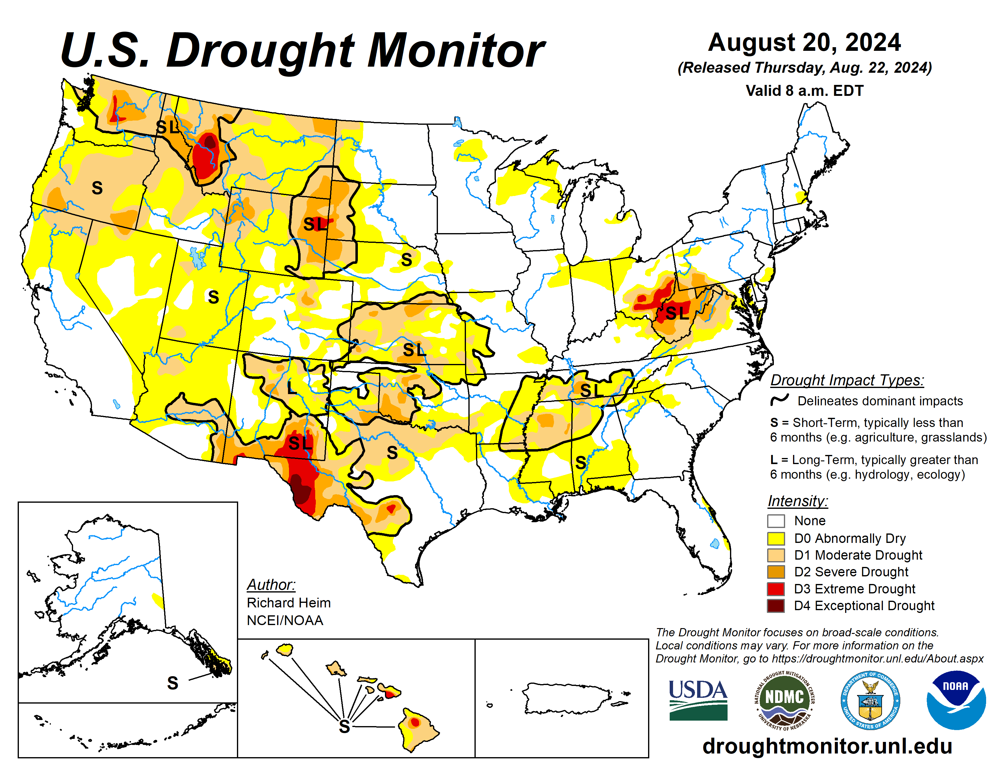
A high-pressure ridge continued across the southern Plains during this U.S. Drought Monitor Aug. 14 to 20 brought dry and very hot weather, especially to Texas.
Pacific weather systems moving in the jet-stream flow brought above-normal precipitation to parts of the West Coast, the northern to central Rockies, and parts of the central to northern Plains, the Midwest, and Northeast. The rain was frequently hit-or-miss, with large parts of the Pacific Northwest to Plains, and Midwest to Northeast, receiving little to no precipitation. In addition, much of the Southwest, and southern Plains to Southeast, were drier than normal.
An upper-level trough kept the Far West cooler than normal, while a large cold front brought cooler-than-normal temperatures to much of the Midwest to East Coast. The rain contracted drought and abnormal dryness in parts of the Rockies to central Plains, and a few parts of the Midwest and East Coast. But drought or abnormal dryness expanded or intensified in parts of the West that missed out on the precipitation, parts of the Great Plains, from the Tennessee Valley to central Gulf of Mexico coast, and parts of the Midwest to central Appalachians.
The lack of rain continued to dry out soils across large parts of the West (especially the Pacific Northwest), in the southern Plains, the Lower Mississippi Valley, and central Appalachians. Numerous wildfires were burning across the West with some sparking up in the southern Plains and western High Plains. The most severe drought areas included the central Appalachians to Upper Ohio River Valley, the Rio Grande River Valley, eastern Wyoming, western Montana, and central Washington.
The U.S. Drought Monitor is jointly produced by the National Drought Mitigation Center at the University of Nebraska-Lincoln, the U.S. Department of Agriculture and the National Oceanic Atmospheric Administration. (Map courtesy of NDMC.)
South
The keywords for the South region are hot and dry. Most of the region was warmer than normal, with only eastern Tennessee near normal. Parts of northern Texas had weekly temperatures 6 to 10 degrees Fahrenheit above normal, with daily high temperatures over 100 degrees all week and exceeding 110 degrees on some days. Parts of Arkansas and eastern Oklahoma received over 2 inches of rain, with locally over 5 inches in places. All of Texas and most of Oklahoma received little to no rain. With dry soils, high evaporation, and deficient rainfall, abnormal dryness expanded in parts of most of the South region states.
Moderate drought expanded in Texas, especially in north central Texas where the fire danger was high and several large wildfires were burning; extreme drought expanded in the Texas Trans Pecos. Moderate to severe drought expanded in. Abnormal dryness and moderate drought were trimmed where the heaviest rains fell in eastern Oklahoma and western Arkansas. Soils were very dry. The U.S. Department of Agriculture topsoil/subsoil percentages were short or very short include 75%/65% for Texas, 53%/49% for Arkansas, and 47%/49% for Oklahoma. The USDA reported 46% of the pasture and rangeland in Texas was in poor to very poor condition.
Midwest
Several areas within the Midwest region received 2 inches or more of rain with Missouri experiencing the heaviest thunderstorms—locally over 6 inches. But other parts were dry, with little to no rain falling. Weekly temperatures averaged warmer than normal in the north, with parts of Minnesota 2 to 4 degrees warmer than normal, and near to above normal in southern Missouri, while the week was near to cooler than normal in between.
Abnormal dryness and drought contracted in other areas, including Missouri.
High Plains
Like other parts of the country, there were wet areas and dry areas in the High Plains region. Weekly rainfall totals ranged from zero in parts of Wyoming to locally over 2 inches in the Dakotas, Nebraska, and Kansas. Eastern parts of the Dakotas and Nebraska averaged near to cooler than normal for the week, but areas to the west and south were warmer than normal, with some areas 2 to 4 degrees above normal.
There was expansion of drought and abnormal dryness in most states in the region, more in the north, and contraction in mostly southern states. The more notable changes were expansion of moderate to severe drought in Kansas and Wyoming with extreme drought being introduced in Wyoming and adjacent South Dakota, and contraction of abnormal dryness and drought in Colorado and Kansas, especially southeast Kansas where locally up to 5 inches of rain fell.
Reports of significant hay loss and early cattle sales in South Dakota may be due to a combination of drought and a June 19 freeze event; other drought impacts include surface water shortage and poor water quality for livestock. According to USDA reports, in Wyoming, 75% of the topsoil moisture and 81% of the subsoil moisture are short or very short and 66% of the pasture and rangeland was rated in poor or very poor condition. More than 40% of the topsoil moisture was short or very short in Nebraska, Colorado, and Kansas, with 55% of the subsoil moisture so rated in Kansas.
West
Half an inch of rain or more in the Rockies, and parts of the Southwest (Four Corners states. Temperatures were cooler than normal in the Far West to Great Basin, averaging as low as 4 to 6 degrees below normal, but warmer than normal in southern and eastern areas, averaging 2 to locally 8 degrees above normal in New Mexico and Montana.
Contraction of abnormal dryness or drought occurred in a few parts of New Mexico and Montana. More than 60% of the topsoil/subsoil moisture was rated short or very short in Montana (78%/79%) and New Mexico (70%/70%).
Looking ahead
In the two days since the Tuesday valid time of this USDM, scattered showers and thunderstorms brought areas of rain to parts of the Southwest, Pacific Northwest, and Plains, but the rest of the contiguous U.S. was mostly dry. For Aug. 22 to 27, the upper-level ridge will slowly shift east, bringing warmer-than-normal temperatures to much of the CONUS between the Plains and Appalachians, while an upper-level trough will move into the West, bringing cooler-than-normal temperatures.
An inch or more of rain is predicted for the Cascades, much of the Southwest (Four Corners States), and parts of the northern Rockies and central Plains. Half an inch of precipitation is forecast for areas in the central to northern Plains. Large parts of the southern Plains can expect little to no precipitation.
For much of the next two weeks, the ridge and trough pattern will continue to slowly move east. The Climate Prediction Center’s 6 to 10 Day Outlook (valid Aug. 27 to 31) and 8-14 Day Outlook (valid Aug. 29 to Sept. 4) favor warmer-than-normal temperatures across the CONUS east of the Rockies, shifting to the East Coast as the ridge moves east.
Odds favor below-normal temperatures over the Pacific Northwest and northern Rockies at first, then over the northern Plains as the trough moves east. The southern tier states are likely to be warmer than normal through the period. Odds favor above-normal from the Southwest to northern Plains and parts of the Gulf Coast states, in the northern Rockies early in the period.
Richard Heim is with the National Oceanic Atmospheric Administration and National Centers for Environmental Information.


