After the intense rains from Hurricane Helene tapered off, this past week was extremely dry over a large majority of the contiguous 48 states.
Rainfall totals exceeding 2 inches were limited to much of the Florida Peninsula, the immediate central Gulf Coast, the Louisiana Bayou, and Deep South Texas. Several small, isolated locations across these areas reported as much as 5 inches of rain. Significant rainfall was hard to find in other areas.
Several tenths of an inch, with isolated totals up to 1.5 inches, fell on Maine, southeastern New England, the central Appalachians and foothills, southeastern Virginia, the Upper Peninsula of Michigan, southeastern Iowa, west-central Illinois, and the Pacific Northwest from the Washington and northern Oregon Cascades to the Pacific Coast.
The remainder of the country recorded at most 0.25 inch of precipitation, with a vast majority of the area measuring no precipitation for the week. This abetted recovery in places devastated by the intense rains and flooding associated with Hurricane Helene, but also caused dryness and drought to persist or intensify.
Rapid deterioration was starting to take place in parts of the Lower Mississippi Valley and southern Great Plains while deterioration proceeded at a slower pace in other parts of the nation affected by dryness and drought. In addition, unseasonably high temperatures accentuated the dryness in many areas, particularly in the Southwest.
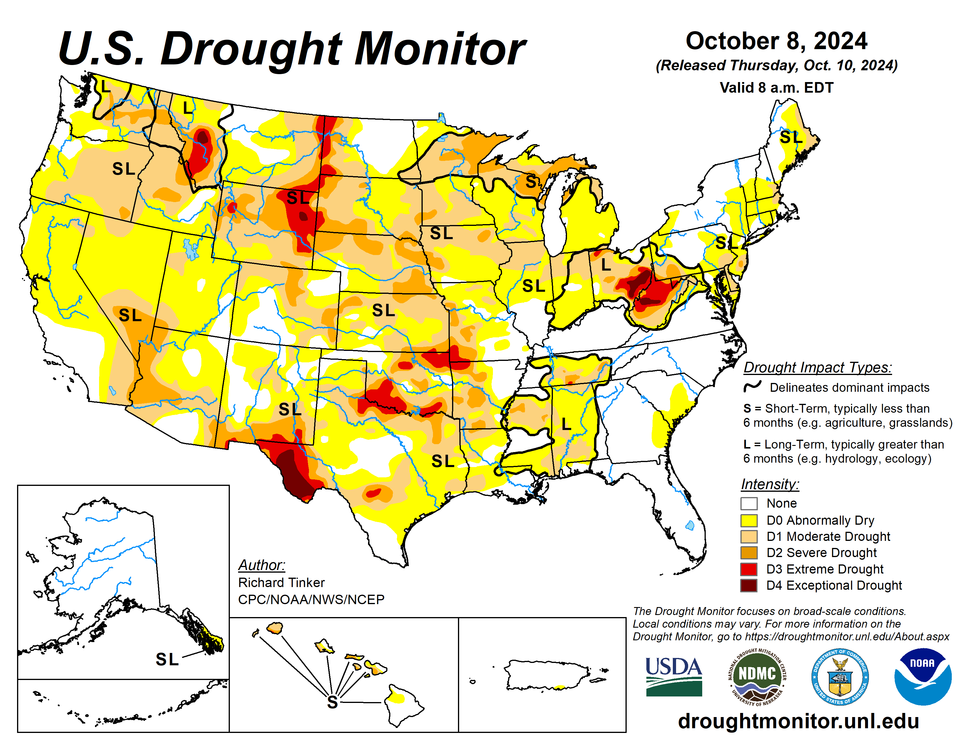
The U.S. Drought Monitor is jointly produced by the National Drought Mitigation Center at the University of Nebraska-Lincoln, the U.S. Department of Agriculture and the National Oceanic Atmospheric Administration. (Map courtesy of NDMC.)
South
Over 2 inches of rain soaked Deep South Texas and the Louisiana Bayou, but amounts decreased rapidly moving away from these areas, and a vast majority of the region saw no measurable rain. As a result, conditions began to quickly deteriorate over a large part of the region.
Dryness and drought of most intensities (D0 to D3) expanded in coverage across large parts of Oklahoma and adjacent Texas, western and eastern Texas, and parts of Louisiana. Currently, exceptional drought (D4) covers a sizeable portion of western Texas, and extreme drought (D3) was assessed in the rest of western Texas, much of the Red River Valley (South), parts of northern Oklahoma, and northwestern Arkansas.
Much of Oklahoma outside the Panhandle, adjacent Texas, and western Arkansas are 4 to 8 inches below normal rainfall since early June. Less than half or normal rain has fallen during this period across and near the Red River Valley (South). Daily high temperatures averaging over 10 degrees Fahrenheit above normal across most of Oklahoma and some adjacent locations worsened the rate of deterioration.
Midwest
Between 0.5 and 1.5 inches of rain fell on a small swath extending from west-central Illinois through southeastern Iowa last week. The rest of the Midwest region reported very light amounts at best, and most locations experienced a dry week with no measurable rain. The continuing impacts from the intense rains of Helene prompted more improvement near and south to southwest of the Ohio River, as far north as southernmost Ohio.
There are a few patches of short-term precipitation surpluses north of the Ohio River, but most of the region continues to record below-normal precipitation. During the last 30 days, significant precipitation has been absent across the northern half of Iowa, Minnesota, and the northern Great Lakes region. Most areas north of the lower Ohio Valley are at least 1.5 inches below normal for the last 60 days. Deficits of 3 to 6 inches are common over most of Minnesota, the northern Great Lakes region, central and northern Iowa, and southwestern Missouri, with the greatest shortfalls affecting part northeastern Iowa and the north-central Great Lakes region.
Above the Ohio River, dryness and drought was relatively unchanged last week from central and south-central Missouri eastward and northeastward across central and southern sections of Illinois and Indiana, and across most of Ohio, where extreme to exceptional drought (D3 to D4) has been in place for several weeks. In contrast, about half of the areas of dryness and drought intensified across northern and western Missouri, Iowa, Minnesota, Wisconsin, northern portions of Illinois and Indiana, Wisconsin, and Michigan.
With 60-day totals under 25% of normal, a new area of extreme drought (D3) was introduced in northwestern Ohio while increasing longer-term deficits brought D3 into southwestern Missouri. Meanwhile, severe drought (D2) expanded significantly to cover most of the Upper Peninsula of Michigan, portions of northern Wisconsin, northeastern Minnesota, and a few areas in southwestern Minnesota, southwestern and northeastern Iowa, and western Missouri. Almost the entire region north and west of central Missouri and the Ohio River are experiencing some degree of abnormal dryness or drought.
High Plains
It was very warm and almost bone dry throughout the region for the second successive week. As a result, D0 to D3 conditions all expanded broadly, and most of the region is currently experiencing some degree of dryness or drought. The only areas free of abnormal dryness are central and eastern North Dakota, a few parts of southwestern Nebraska and western Kansas, northeastern Colorado, and parts of southern and western Colorado.
A small patch of exceptional drought (D4) was introduced in east-central Wyoming, and extreme drought (D3) expanded across a large part of eastern Wyoming, much of the western tier of the Dakotas, and a couple small patches in southeastern Kansas.
Since early June, precipitation has totaled less than half of normal through most of east-central and northeastern Wyoming, and shorter-term deficits of varying intensities envelop most of the High Plains Region.
In addition, dryness was exacerbated by high temperatures averaging at least 5 degrees above normal last week region-wide, and more than 10 degrees above normal in most of Colorado and Wyoming, plus a few other scattered patches.
West
Areas from southern Montana, central Idaho, and southern Oregon southward through the Great Basin, California, Arizona, and western New Mexico reported high temperatures averaging over 10 degrees above normal, with most of California and the adjacent Southwest enduring almost summerlike heat 15 to 20 degrees above normal for this time of year.
For the past two months, high temperatures have averaged 4 to 8 degrees above normal over central and eastern Montana, and through most of Arizona and some adjacent areas, including southern Nevada. A few locations in eastern Montana averaged more than 8 degrees higher than normal.
Drought tends to move slowly this time of year in the West region, where light precipitation often doesn’t keep up with water loss to evapotranspiration and human usage, but the excessive heat has caused drought conditions to intensify at a quicker rate than usual.
Much of the West, south and east of the Cascades, saw conditions deteriorate sufficiently to justify an increase in the Drought Monitor classification, with a large D2 expansion in the Southwest. D2 to D4 conditions (severe to exceptional drought) also covered western Montana, unchanged over the past several weeks. On the southern tier of the West region, D2 and D3 conditions increased slightly in coverage over southern New Mexico.
Looking ahead
During the next five days, Oct. 10 to 14, Hurricane Milton will contribute to excessive rainfall across much of the central and northern Florida Peninsula. Little or no precipitation is expected across the remainder of the contiguous U.S., including most areas impacted by dryness and drought. Temperatures are anticipated to be above normal from most of Texas and the High Plains westward to the Pacific Coast. Daily maximum temperatures are forecast to average 10 to 16 degrees above normal across the northern halves of the Rockies and Intermountain West.
The Climate Prediction Center’s 6- to 10-day outlook for Oct. 15 to 19 favors enhanced chances for wetter than normal weather also cover the Pacific Northwest and northern Intermountain West. Meanwhile, subnormal precipitation is favored from the Plains and into the central Rockies and eastern Great Basin.
Warm weather is favored from the northern Great Lakes, central Great Plains, and southern High Plains westward to the Pacific Coast. Chances for unusually warm weather exceed 70% in the northern High Plains and the northern half of the Rockies. Farther east, lower than normal temperatures are expected in the southeastern Great Plains.
Richard Tinker is with National Oceanic Atmospheric Administration, National Weather Service, National Centers for Environmental Prediction and Climate Prediction Center.
Related Articles


