Heat dome brought warmer temps for holiday season
A massive heat dome settled over the central and southern United States, creating unprecedented warmth for the holiday week.
This high-pressure system shattered daily high-temperature records, with readings soaring 15 to 35 degrees Fahrenheit above average across the region. Numerous daily records were broken between Dec. 24 to 27, contributing to what was forecast to be the warmest Christmas Day on record for the contiguous U.S.
The weather pattern snapped violently late in the weekend as a powerful winter cyclone swept eastward from the Plains between Dec. 27 and 29. This system drove a sharp cold front through the South, causing temperatures to plummet from record highs to near freezing overnight. Simultaneously, the storm unleashed severe winter conditions across the Upper Midwest and Great Lakes, delivering blizzard conditions and up to two feet of snow near Lake Superior, alongside significant ice accumulations that snarled travel in parts of the Northeast.
Precipitation was near- to below-normal for much of the country, while much of the West, and parts of the Midwest and Northeast observed above-normal precipitation during this week. The West Coast was a notable exception where a strong atmospheric river brought heavy precipitation to most of California, dumping over 10 inches of rain in some areas and several feet of new snow in the mountains.
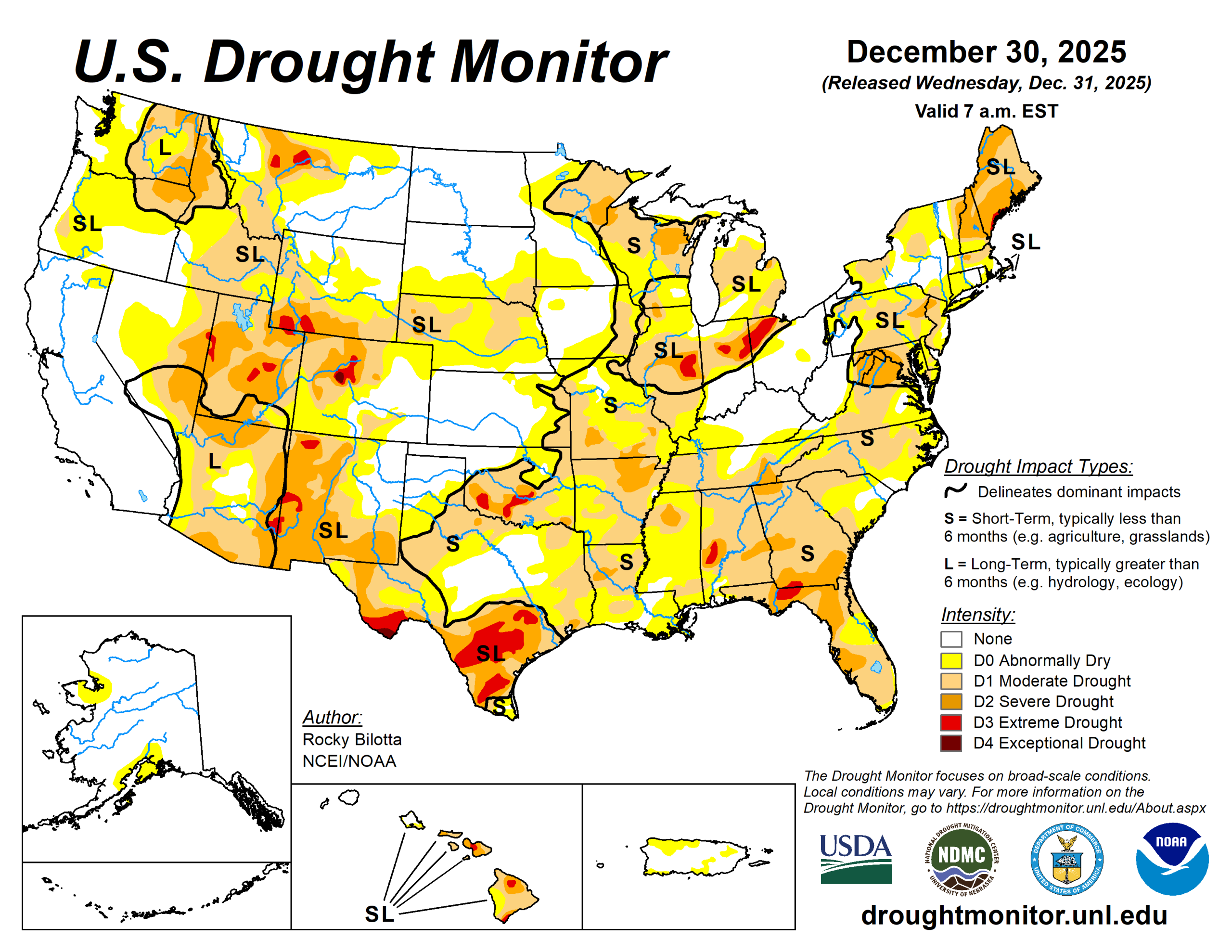
The U.S. Drought Monitor is jointly produced by the National Drought Mitigation Center at the University of Nebraska-Lincoln, the U.S. Department of Agriculture and the National Oceanic Atmospheric Administration. (Map courtesy of NDMC.)
South
Below-normal precipitation and above-normal temperatures dominated the South, resulting in widespread drought degradation across the region. Temperatures were above normal for the entire region, with departures ranging from 5 degrees to 5 degrees. Dry conditions also persisted, with monthly rainfall totals ranging from 1 to 5 inches below normal (5% to 25% of normal) for December.
Extreme drought (D3) expanded in central Texas, while severe drought (D2) was introduced or expanded in southeast Oklahoma and southeast Texas, parts of central Texas, and northeast Arkansas. Moderate drought (D1) and abnormal dryness (D0) expanded across much of the region.
Midwest
Above-normal temperatures, with departures ranging from +5 to +25 degrees, were observed across most of the Midwest. The largest temperature departures (+25 degrees) were observed in southern Missouri.
Abnormal dryness (D0) saw improvements in central Minnesota. Growing precipitation deficits and degrading conditions—indicated by short-term indicators, streamflow, and soil moisture data—resulted in the addition of severe drought (D2) in southeast Missouri and the expansion of moderate drought (D1) in Missouri.
High Plains
Warmer-than-average temperatures dominated the High Plains, with departures ranging up to 25 degrees above normal, while near- to below-normal temperatures were observed along northern portions of the region.
Precipitation varied across the region, with most areas reporting near- to below-normal totals. Western Wyoming was the exception, where weekly precipitation totals were 200% to 600% of normal. Consequently, severe drought (D2) was removed from western Wyoming, while moderate drought (D1) and abnormal dryness (D0) improved.
Conditions were drier on the east side of the state, justifying the expansion of abnormal dryness in those areas. The majority of the southern half of the High Plains observed temperatures 10 to 20 degrees above normal for the week, while precipitation totals were reported to be 25% or less of normal.
Extreme drought (D3) expanded in central Colorado, while moderate drought (D1) expanded in southern Colorado, across northern portions of Nebraska, and in southeast Kansas. Abnormal dryness (D0) expanded across northeast Colorado, southern and northern portions of Nebraska, and in southeast Kansas.
West
Temperatures were above normal across much of the West, while below-normal temperatures were observed along parts of the West Coast and in northern Montana. For the week, temperature departures ranged from -10 degrees below normal in northern Montana to 25 degrees above normal in parts of Nevada and Utah.
Precipitation varied across the region, with beneficial amounts falling across much of the southwest and parts of the north. Over the past 14 days, much of the West has received 2 to 20+ inches of precipitation, with departures ranging from 1 to 8 inches above normal (150% to 800% of normal). This above-normal precipitation reduced severe drought (D2) coverage in northern Montana. Moderate to severe drought (D1-D2) conditions improved in portions of Montana.
Looking ahead
During the next five days (Dec. 30 to Jan. 3), a highly amplified pattern will create a sharp divide across the Continental U.S. An upper-level ridge situated over the West Coast will keep conditions initially quieter there, while a broad trough east of the Mississippi River will usher in cold air and active winter weather to the eastern states.
A strong low-pressure system exiting the Northeast will leave behind blustery conditions and significant lake-effect snow, particularly downwind of the Great Lakes where accumulations of 1 to 2 feet are possible in Upstate New York.
Below-average temperatures will grip the region from the Northern Plains to the East Coast, with the coldest conditions centered on the Upper Midwest where highs in the single digits and subzero overnight lows are expected. Dangerous wind chills may affect the central Gulf Coast and Southeast early in the period. Conversely, much of the West and High Plains will experience above-average warmth. By Thursday and Friday, the weather pattern will shift in the West as Pacific systems move in, bringing rain and mountain snow back to the coast, with potential heavy precipitation in Southern California and snow in the Sierra Nevada.
The Climate Prediction Center’s 6- to 10-day outlook (valid Jan. 4 to 8) favors above-normal precipitation across the Pacific Coast and parts of the interior West, and in parts of northern Plains and New England.
Below-normal precipitation is favored from the central and southern Plains into portions of the Ohio Valley.
Probabilities for above-normal temperatures are increased across most of the U.S.
Rocky Bilotta is with the National Oceanic Atmospheric Administration and National Centers for Environmental Prediction.


