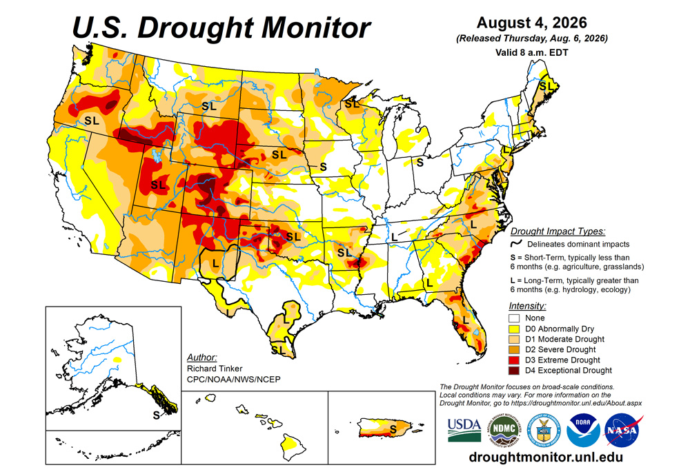
Heavy to excessive rains fell on some areas of dryness and drought, from the central and northeastern Great Plains eastward through much of the Great Lakes Region and Lower Ohio Valley, prompting a few swaths of improvement there. But while heavy rains broadly affected the Eastern Seaboard and the Midwest, there were a few regions that missed the heavier amounts, leaving conditions essentially unchanged or even allowing for some deterioration. Temperatures averaging 6 to locally 12 deg F above normal in parts of the Upper Mississippi Valley and Great Plains, along with unusually low relative humidity across much of the Dakotas and Nebraska, accelerated surface moisture loss.
To the south, heavy rain was not as widespread across the Lower Mississippi Valley, the southern half of the Great Plains, and most of the High Plains. Still, moderate rains were not uncommon here, and there were isolated heavy amounts topping 2 inches. Thus, a variable pattern featuring areas of both deterioration and improvement was observed, with many locations essentially unchanged. Precipitation was markedly deficient from southern Kansas southward through much of Texas, resulting in broad areas of deterioration. Most of these areas were also warmer than normal, although humidity was not lacking. Much of the Texas Panhandle averaged 6 to 9 deg F above normal for the week. Other parts of this region were not as extreme, but most sites still averaged somewhat warmer than normal
From the Rockies westward, precipitation was sparse. Moderate amounts, with isolated totals over 2 inches, fell in association with the Southwest monsoon across portions of New Mexico and Arizona. Over the remainder of the West, scattered areas recorded several tenths of an inch to slightly over an inch across the Rockies and far Pacific Northwest, but most places recorded light precipitation at best. Very little rain fell across the Intermountain West, Great Basin, the interior Pacific Northwest, and California, although this is a dry time of year for many of those areas. Temperatures were above normal outside the Pacific Northwest
South
Moderate to heavy rain was fairly widespread across central and eastern Tennessee and the eastern half of Mississippi, although amounts exceeding 2 inches were mostly limited to north-central and southeastern Tennessee. Light rain (several tenths of an inch) with scattered higher totals were observed farther west across Arkansas and, to a lesser extent, Louisiana. Farther west, there were a few swaths of moderate to heavy rain in parts of northwestern Texas, eastern Oklahoma, and central to southwestern Texas, but most of these two states reported no measurable rain to a few tenths at best. Recently, very hot weather has baked the norther portion of this region from the Red River Valley and the Texas Panhandle northward. Temperatures averaged 1-3 deg F above normal in northeastern Texas, 3 to 6 deg F above normal across most of Oklahoma, and 5 to 9 deg F above normal in the Texas Panhandle. Portions of Deep South Texas were also warmer than their typical mid-summer temperatures. The dryness and heat have accelerated deterioration across Oklahoma and northern Texas, where many locations are seeing dying grass, depleted stream-fed and farm ponds, and increased fire danger. The past 30 days brought less than half of normal rain to most locations from the Texas Panhandle and the Red River Valley northward, with the driest areas (less than one-quarter of normal) covering the central and eastern Texas Panhandle, western and northern Oklahoma, and some regions near the Red River. Subnormal humidity at the same time also aggravated the situation in the Texas Panhandle and western Oklahoma. As a result, drought degradation was widespread across most of Oklahoma and northern Texas, indicative of rapid surface moisture loss. Other areas of significant deterioration included western Texas, Deep South Texas, and western Arkansas. Abnormal dryness was also brought in to a few spots across Louisiana and Mississippi while more intensely dry conditions over portions of Arkansas and adjacent Mississippi were essentially unchanged. The past 30 days also brought less than half of normal rain to numerous locations across western and southern Texas, Arkansas, northern and eastern Louisiana, and central through southern Mississippi. Improvement was limited to portions of the wetter areas across eastern Tennessee.
Midwest
Moderate to heavy rains fell on much of the Region, with amounts of at least 0.5 inch falling on most locations. Swaths of heavy to excessive rainfall (over 2 inches) were noted over sizeable areas in northwestern and southern Minnesota, southern and eastern Iowa, southern Wisconsin, much of northern Illinois, central Indiana, parts of western Ohio, and isolated locations across southern Kentucky, the Upper Peninsula of Michigan, and central through northern Missouri. For the most part, maximum precipitation totals of about 5 inches were observed in isolated spots across the aforementioned areas, but excessive amounts of 5 o 7 inches were more widespread in a band stretching from Kandiyohi and Chippewa Counties in interior southern Minnesota southeastward through portions of Renville, McLeod, Sibley, and Le Sueur Counties. All dryness and drought was removed from this region, and relatively broad areas of improvement were also introduced in northwestern Minnesota, southeastern Wisconsin, northern Illinois, parts of central and northwestern Indiana, and southeastern Kentucky. In sharp contrast, heavier rains missed some areas in the Region, and in areas where dry weather had prevailed over the previous few weeks, dryness and drought intensified. This included east-central and west-central Michigan, northern Wisconsin, part of central and northwestern Iowa, and the northern and southern tiers of Missouri. These locations recorded 10 to 50 percent of normal rain for the past 30 days while 90-day totals near or under half of normal were observed through northern Wisconsin, parts of central and northern Minnesota, and a few patches farther south across Lower Michigan, Missouri, Illinois, and some of northern Indiana and Ohio. 90-day deficits of 4 to locally 8 inches encompass much of northern Wisconsin and adjacent Michigan, and a few other areas scattered across the Region.
High Plains
Conditions varied significantly across the High Plains Region last week. Heavy rains of 2 to 5 inches with isolated higher amounts fell on northeastern South Dakota, a large part of northern and eastern Nebraska, and northeastern Kansas. Moderate to heavy amounts were observed elsewhere across the eastern and central sections of the Dakotas and Nebraska, southern and north-central and east-central Kansas, southeastern and the higher elevations farther west in Colorado, and patches of central and northern Wyoming and the western Dakotas. In the some of the drier parts of the region across North Dakota, central and western South Dakota, and western Nebraska, unusually hot weather accompanied the relatively low rainfall amounts. For the last 30 days, these locations generally averaged 4 to 8 deg F above normal, with a few spots in the western Dakotas and adjacent parts of Wyoming and Nebraska reporting 30-day average temperatures 8 to 10 deg F above normal. This included a few spells of extreme heat with high temperatures over 100 deg F. At the same time, relative humidity has been unusually low. Many areas across eastern Wyoming, western South Dakota, and adjacent Nebraska reported 4-week relative humidity averaging among the driest 10 percent of historic observations for the time period, and a few isolated spots were as dry as the lower 2 percent of historical observations. Less remarkable but still consistently below-normal relative humidity has prevailed over most of the region from the central Dakotas and Nebraska westward, along with most of Colorado. The dichotomy of conditions between eastern and western reaches of the Region is reflected in the changes introduced in the Drought Monitor this week. Most of North Dakota, the western half of South Dakota, and parts of northeastern Wyoming, western Nebraska, and northeastern Colorado saw conditions deteriorate, as did southern Kansas adjacent to Oklahoma. Meanwhile, eastern South Dakota, central through eastern Nebraska, southeastern Colorado, and western Wyoming notched sizeable areas of improvement. A new patch the worst drought classification (D4) was brought into northwestern Nebraska and another introduced in part of the Denver Metro Area. Existing areas of D4 remained intact in the Nebraska Panhandle, east-central Colorado, south-central and interior western Colorado. A majority of Wyoming and Colorado remain entrenched in D3, as do western reaches of Nebraska and South Dakota along with a few scattered locales farther south and east. In contrast, dryness has been entirely removed from sizeable parts of southeastern Nebraska, eastern Kansas, and the east-central Dakotas.
West
Areas of moderate to locally heavy rain, at least partially driven by a mature monsoon circulation, were observed across much of southern and eastern New Mexico, southeastern Arizona, the higher elevations of central Arizona, and a few scattered patches stretching from southern Utah northward through southeastern Idaho, southern Montana, and eastern Montana. A few swatches received similar amounts in western Washington. Other locations recorded little or no precipitation, although this is not uncommon during summer across much of California and the Far West. Conditions across southeastern Idaho and southern Montana have been exacerbated by temperatures averaging 6 to 10 deg F above normal during the past 30 days, including a few days of intense heat. Near- or below-normal temperatures during this period were restricted to the Pacific Northwest, central and northern California, and western Nevada. Relative humidity has been seasonably low during this period. The dry and hot conditions are not too out of character for July across California, Nevada, and southern Oregon, with drought designations unchanged from last week. Farther north, the lack of winter snowpack despite ample winter precipitation is starting to take its toll, with increasing moisture shortages leading to degradations across eastern Washington, northwestern and eastern Oregon, much of the Idaho Panhandle, and parts of eastern Montana. Meanwhile, locally heavy precipitation over the past few weeks, enhanced by rain from a mature monsoonal circulation, prompted localized areas of improvement in west-central New Mexico, parts of southeastern Arizona and some higher elevations farther north in the state, and a few places scattered across Utah.
Looking Ahead
During August 5-10, 2026, a decided lack of heavy rainfall is forecast across the Contiguous States. A few areas are expecting 1.5 to locally 3.0 inches of rain, but they are not extensive and include central Missouri, a few scattered patches along the Appalachians from western North Carolina to Upstate New York, isolated spots in southwestern Wisconsin and southwestern Michigan, and portions of central and west-central Florida. Totals of 1 to 2 inches are also possible in southeastern Arizona as well as some higher elevations in the state. Amounts exceeding an inch are also forecast across a large swath of Missouri and some adjacent areas, the southern Great Lakes and adjacent Mississippi Valley, most of western Pennsylvania, several areas in the Appalachians from northern Georgia through West Virginia, east-central Pennsylvania, portions of Upstate New York and adjacent Vermont, and the southern half of the Florida Peninsula. Scattered small patches across the central and eastern Gulf Coast, southeast and central Arizona, and northern New England may also record 1 to 1.5 inches. Other areas from the Mississippi Valley eastward are expecting light to moderate rain, with only a few tenths of an inch at best in much of the Lower Mississippi and Tennessee Valleys, southeastern Virginia, and adjacent North Carolina. Farther west, monsoonal moisture is expected to trigger light to locally moderate rains over parts of Arizona and New Mexico. Elsewhere from the central Great Plains westward, little or no precipitation is anticipated. Most of the country can expect near to above-normal temperatures during this period, especially over the Great Plains westward, where locations outside the Pacific Northwest and immediate West Coast are expected to record temperatures 5 to 11 deg. F above normal, with the greatest departures covering southern Kansas, the Texas and Oklahoma Panhandles, most of Colorado, and some adjacent areas. Temperatures east of the Mississippi River are expected to be closer to normal, although a few areas are expected to record somewhat warmer than normal conditions. Temperatures should average 4 to 6 deg F above normal across the Tennessee and adjacent Lower Mississippi Valley, across parts of the Mid-Atlantic Region, and northern New England.
The 6- to 10-day outlook (August 11-15, 2026) at least marginally favors above-normal precipitation from the Southwest, Great Basin, and Intermountain West eastward into the Great Plains. The best chances for significantly above-normal precipitation (over 50 percent) cover areas expected to be under the influence of the Southwest monsoon, from Arizona through most of Utah, eastern Nevada, and the southeastern California deserts. Odds lean toward above-normal precipitation in most of the eastern half of the country as well, excepting only the northwestern Great Lakes and adjacent Mississippi Valley, the southeastern Great Plains, the Gulf Coast and adjacent locales, and the lower Eastern Seaboard south of the Carolinas and central Georgia. Across the Contiguous States, enhanced chances for subnormal rainfall are limited to the Florida Peninsula. In Alaska, near normal precipitation is expected in central parts of the state and across most of Southeast Alaska, with subnormal amounts nominally favored in far southeastern areas that where moderate drought newly emerged this week. Above-normal precipitation is expected over most of Hawaii outside Kauai, with the best chances (over 40 percent) covering most of the Big Island. Meanwhile, warmer than typical mid-August conditions are favored across most of the Contiguous States, and throughout Alaska and Hawaii. Odds favor anomalous warmth from the Middle and South Atlantic Regions westward through the central and southern Great Plains, then from the entirety of the Rockies to the Pacific Coast. Chances for significantly above-normal temperatures are highest (near 80 percent) across the Big Island and southeastern Maui in Hawaii. The likelihood of above-normal temperatures exceeds 60 percent in a swath across central Alaska, in portions of the Lower Mississippi Valley and southern Great Plains, and the South Atlantic Region from most of Florida through eastern South Carolina.
Related coverage and resources
- Related on HPJ: Heat and dry conditions story of the High Plains
- Related on HPJ: Drought conditions shift as storms bring mixed changes across Plains
- Outside resource: U.S. Drought Monitor — Current drought conditions and weekly summaries