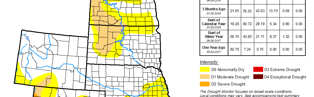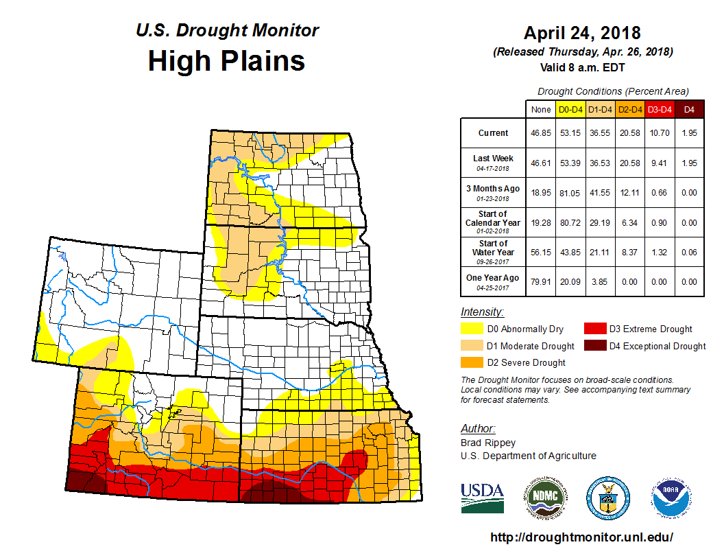
According to the U.S. Drought Monitor for April 24 released on April 26, southern High Plains’ second wildfire outbreak in less than a week preceded the arrival of storm system that provided much-needed rainfall on April 20 and 21. Rainfall in the Plains’ drought-affected areas generally totaled around an inch or less. (Additional rain fell across portions of the central and southern Plains on April 24 and 25 but will be largely reflected next week.) The fires peaked in intensity on April 17, when southwesterly winds fanned flames amid soaring temperatures, but continued into the following day when winds shifted to a northwesterly direction. Oklahoma’s two largest April wildfires—the Rhea Fire (in Dewey County) and the 34 Complex (in Woodward County)—were nearly fully contained by April 24 after destroying more than seven dozen structures and charring approximately 350,000 acres of brush and grass. Meanwhile, drought continued to intensify in parts of the Southwest, where dry, windy weather prevailed. In contrast, another round of heavy rain struck portions of the South and East, as the slow-moving storm system that had produced beneficial rainfall on the southern Plains eventually drifted eastward.
Following the previous week’s significant drought reductions across the northern Plains, there were no further changes in the High Plains during the drought-monitoring period that ended on the morning of April 24. However, some short-term precipitation deficits have been observed during the last month near the Canadian border in North Dakota and Minnesota, and this area will be closely monitored. Through April 24, month-to-date precipitation totaled 0.15 inch (21 percent of normal) in Grand Forks, North Dakota, and 0.28 inch (25 percent) in International Falls, Minnesota. Farther south, high winds and dramatic temperature fluctuations preceded the April 20 and 21 rainfall event. For example, Dodge City, Kansas, notched consecutive daily-record lows (19 and 23 degrees F, respectively) on April 15 and 16, followed by a daily-record high of 94 degrees F on April 17. Dodge City also clocked a wind gust to 66 mph on the April 17, shortly after the passage of a strong cold front ended the short-lived hot spell. By April 19, daily-record lows were observed in Kansas locations such as Russell (26 degrees F) and Wichita (31 degrees F). (Russell and Wichita had also reported daily-record lows on April 16—with 18 and 21 F, respectively.) Some additional precipitation arrived on April 24, as the monitoring period ended. In most cases, the precipitation was highly beneficial but did not provide significant or sustained drought relief. On April 22, topsoil moisture was rated 64 percent very short to short in Kansas and 53 percent very short to short in Colorado. For both states, that represented an 8-point improvement (from 72 and 61 percent very short to short, respectively). Winter wheat condition actually declined during the week ending April 22, with the portion of the crop rated very poor to poor increasing from 24 to 29 percent in Colorado and from 46 to 49 percent in Kansas.