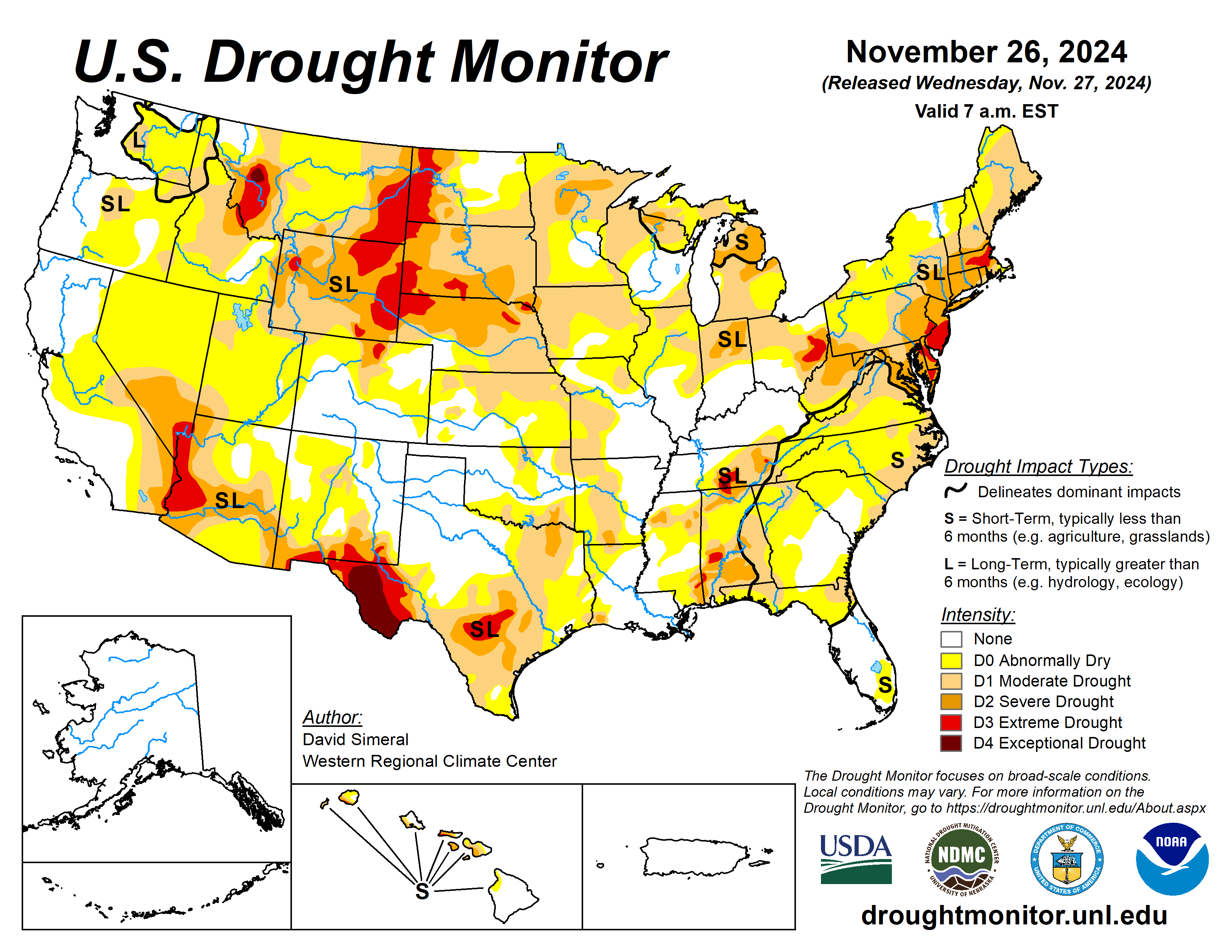
This U.S. Drought Monitor week saw widespread improvement in drought-related conditions across areas of the Pacific Northwest and northern California. It came in response to a series of strong Pacific storms including a powerful atmospheric river that delivered significant rainfall accumulations to the lower elevation coastal areas and heavy mountain snow.
In New Mexico, the state’s largest reservoir along the Rio Grande is currently 7% full (17% of average). In the Pacific Northwest, Washington’s Franklin D. Roosevelt Lake is 90% full (103% of average for the date), Idaho’s American Falls Reservoir on the Snake River is 35% full (86% of average), and Hungry Horse Reservoir in northwestern Montana is 82% full (100% of average).
The U.S. Drought Monitor is jointly produced by the National Drought Mitigation Center at the University of Nebraska-Lincoln, the U.S. Department of Agriculture and the National Oceanic Atmospheric Administration. (Map courtesy of NDMC.)
South
Across the region, generally dry conditions prevailed this week, especially in the western portion of the region, with little or no precipitation observed across the western half of Texas and Oklahoma.
On the map, deterioration occurred in isolated areas of Texas including the Trans Pecos, South Texas, and the southern Edwards Plateau, while improvements were made in the Panhandle and east Texas. Looking at reservoir conditions in Texas, Water for Texas (Nov. 26) was reporting statewide reservoirs at 72% full, with many reservoirs in the eastern part of the state in good condition, while numerous reservoirs in the western portion of the state were experiencing continued below-normal levels.
Midwest
On this map, widespread improvements were made in response to improving conditions during the past 30-day period including beneficial rain and snowfall across areas of the region. Light to moderate snowfall accumulations (1 to 7 inches) were reported across northern Minnesota.
For the week, average temperatures were above normal across the region, with anomalies ranging from 1 to 10 degrees Fahrenheit above normal and the greatest departures observed in northeastern Minnesota.
High Plains
Only minor changes were made in the region including in eastern Nebraska and western North Dakota. For the week, precipitation across the region was generally light and primarily restricted to eastern portions of the Dakotas and Nebraska as well as western and northern portions of Kansas.
However, some isolated moderate-to-heavy snowfall accumulations were observed in the Dakotas last week, including 14 inches reported at Lake Metigoshe State Park in northern North Dakota. In terms of average temperatures, cooler-than-normal temperatures (3 to 9 degrees below normal) were observed across the Dakotas, while the southern portion of the region experienced temperatures 1 to 5 degrees above normal in eastern Nebraska and Kansas.
West
Out West, a series of powerful Pacific storms delivered heavy rain and mountain snow accumulations to the Pacific Northwest and Northern California. Impacts from the series of storms included damaging winds, major power outages, flash flooding, road closures, landslides, and debris flows. The atmospheric river last week boosted snowpack conditions in Montana, helping to improve drought-affected areas in the northwestern part of the state.
David Simeral is with the Western Regional Climate Center.


