Conditions took a dramatic turn across the Rockies and Plains, with hot and dry conditions suddenly replaced by much colder weather, and snow in some areas. A number of sites from the central Rockies into the northern Plains saw temperatures drop from around 90 degrees F Labor Day to near freezing with light snow the next morning. Denver, CO went from temperatures averaging 15 degrees above normal on Sept. 6 to 30 degrees below normal for Sept. 8, with an inch of snowfall reported.
East Rapid City, South Dakota, appears to have set a national all-time record by going from over 100 degrees F (102) to reporting measurable snow in a span of two days. The colder and wetter weather that developed just as the period ended had little impact on drought conditions in most areas, given the hot, dry, and windy conditions that preceded it. Wildfires continued to scorch and spread rapidly across parts of California, with some quickly breaking out and expanding in part of the Rockies as well. Denver, Colorado, went from reporting reduced visibility due to wildfire smoke on Labor Day, to reduced visibility from falling snow the next morning. Elsewhere, several inches of precipitation across interior northeastern Texas, in a swath from eastern Iowa to central Illinois, across Ohio, and in parts of Arkansas brought significant drought relief, and lesser amounts in adjacent areas brought more limited improvement, as did moderate precipitation in parts of the northern Rockies and adjacent Plains.
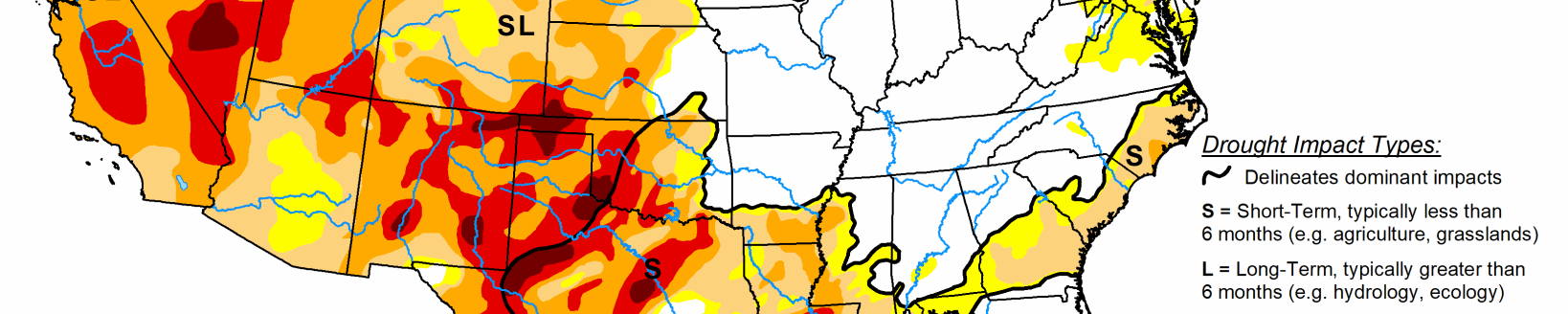
High Plains
The dramatic change to cold and wet (often snowy) conditions late in the period only brought notable improvement to southwestern North Dakota and part of interior southeast Colorado. Elsewhere, a few tenths of an inch of precipitation fell on the central Dakotas, scattered parts of Nebraska, and much of Wyoming, but given the hot and dry weather that prevailed until the end of the period, no areas experienced notable improvement. In fact, sizeable parts of northern North Dakota, the southern half of Wyoming, central and western Colorado, and Nebraska deteriorated. As a result, a large area of extreme drought (D3) now covers central and western Colorado and the central tier of Wyoming. Smaller areas of D3 are in north-central Wyoming and part of the Colorado Plains, with a small area of exceptional D4 drought persisting in the latter area. Conditions generally improve moving north and east of the D2 to D3 regions in the central Rockies and west-central Plains, though some severe to extreme drought expanded across central Nebraska while D2 to D3 persisted adjacent to Iowa.
South
Heavy rain soaked a large area across northeastern Texas, dramatically easing or ending drought and abnormal dryness. Some 2-category improvements were noted in the wettest areas. Heavy precipitation was less widespread in Arkansas and some adjacent areas, reducing the extent of abnormal dryness there. Across western Texas and farther east in Mississippi, dryness and drought expanded and intensified. Much of western Texas is now in extreme drought, with a small area of exceptional D4 drought in the interior Big Bend area. Parts of this region have received only a few tenths of an inch of precipitation since early August. Farther east, moderate drought was introduced in part of interior northeastern Mississippi where less than half of normal rainfall was recorded during the last 60 days.
Midwest
Generally 3 to 6 inches of precipitation fell from eastern Iowa to central Illinois, and in parts of central and northern Ohio, bringing significant relief to dry areas there. In contrast, little or none fell on most of Missouri, western Iowa, central and northern Minnesota, central and northern Wisconsin, most of the Upper Peninsula of Michigan, the southern half of Indiana, and most of southern Illinois, allowing for dryness and drought expansion in a few parts of these areas. Light to moderate precipitation elsewhere kept conditions generally unchanged from last week.
West
Another dry and, until the end of the period, hot week led to broad areas of drought intensification. The most widespread deteriorations were noted across Utah, Arizona, and to a lesser extent New Mexico. Exceptional D4 drought was introduced in central Utah, and a large area of extreme drought now envelops most of Utah, Arizona, northern and eastern New Mexico, and farther northwest through much of Oregon and adjacent California. Only parts of southwestern California, western Washington, central and southern Idaho, and adjacent areas remain free of abnormal dryness and drought. Fires continued to rage in portions of California, now having scorched over 2,000,000 acres in the state. Less than 30,000 acres were consumed by fire in 2019 through early September.