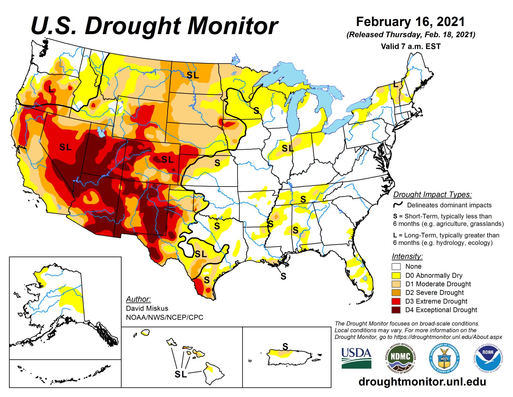
Arctic air spilled into the nation’s midsection and persisted throughout the week, producing weekly departures of more than 25 deg F below normal from the northern Plains and upper Midwest southward into Texas. Numerous daily record lows were broken, with minimums plunging to -50 deg F in the northern Plains, and sub-zero readings southward into the Texas Panhandle.
In contrast, high pressure over the Southwest and Southeast kept temperatures above-normal for the week. With several storm systems traversing along the boundary of the cold vs mild air, ample precipitation, much in the frozen form, fell on most of the West Coast, Intermountain West, Rockies, southern and central Plains, and much of the eastern third of the U.S. The combination of extreme cold and frozen precipitation across the South and Southeast taxed the power grid, made transportation hazardous, and brought down trees. The snows, however, were welcomed in the West as snow packs and basin snow water equivalents increased throughout the West, although many basins were still below normal as of Feb. 16, especially in the southern Rockies.
High Plains
While bitterly cold air enveloped the High Plains this week (except western Colorado and southwestern Wyoming), frequent storm systems have zipped their way across much of the region, dropping snow across both high and low elevations. After several weeks of decent precipitation, some improvements were warranted for those areas with surplus precipitation out to 2-3 months and wet short-term SPIs. Although longer-term SPIs (>6 months) were still severe, the short-term conditions have been wetter, and this is what these improvements were attempting to depict. This included 1-cat improvements to parts of Nebraska and adjacent western Iowa, sections of Wyoming, southeastern Montana, northeastern Kansas, and portions of Colorado. As mentioned in the Midwest summary regarding western Iowa, low elevation snow melt and infiltration into the soils can have problems, so take these improvements with caution. Fortunately, higher elevation (mountain) snows tend to melt more evenly and slowly. In sharp contrast, storms and precipitation continued to elude the frozen northern Plains, but unfortunately the bitterly cold Arctic air did not.
South
Arctic air set up shop in parts of the region, especially Oklahoma, Texas, northern Louisiana, Arkansas, northern Mississippi, and western Tennessee, with wintry weather blanketing or glazing many parts of these states. Although the precipitation was welcome after a rather dry 30-60 days prior, the form it came in (frozen) was not, nor was the Arctic air. With light to moderate totals (0.5-2 inches) from south-central and eastern Texas northeastward across the remaining Southern states, and heavier totals (2-5 inches) in southern sections of Louisiana and Mississippi, some D0 and D1 was improved, especially along the central Gulf Coast. However, since there were 60-day deficits of 3-6", the precipitation in the lower Mississippi Valley was not great enough to eliminate them, thus many areas remained unchanged. But with the combination of the extreme cold (no evaporation) and widespread precipitation, no deteriorations were made this week.
Midwest
With bitterly cold conditions in place across much of the Midwest, and light precipitation generally confined to eastern locales (e.g., Illinois, Indiana, Ohio, Kentucky, and lower Michigan), status-quo was the best bet. However, the past 90-days have been unusually dry (40-60% of normal) in the western Great Lakes region, and with 90-day SPIs in the D2-D4 range, D0 was added in northeastern Wisconsin, Upper Peninsula of Michigan, and northern lower Michigan. But impacts are basically non-existent with a decent snow covering the ground and frigid temperatures that prevent any melting. Southern lower Michigan was also being considered for D0 expansion, but Day7 brought moderate snowfall and quelled any D0 addition. In western Iowa, continued rounds of snow during the past 30-90 days have pushed short-term indices into the normal to wet categories, and with this “water in the bank” for future snow melt, some slight improvements were made to the D2 areas – however, these improvements assume that the snow melt will infiltrate into the topsoil and not runoff or sublimate, so be careful—especially since this area also has a long-term drought (subsoil) component.
West
Another in a series of Pacific storms battered the West Coast and tracked southeastward across the Intermountain West and Rockies, dropping heavy precipitation (more than 4 inches) along the Washington-Oregon-northwest California coasts and on the Cascades, with lighter totals (2-4 inches) falling on the Sierra Nevada. Beneficial precipitation fell farther east on higher elevations of northeastern Oregon, most of Idaho, northern Nevada, central Utah, western and eastern Wyoming, western Colorado, northeastern Arizona, and most of New Mexico. With precipitation increasing over the past 30 days or so, short-term indices not showing D3-D4 on multiple time scales (short-term much wetter), and SNOTEL basin average SWE (as of Feb. 16) improving and getting closer to normal (but still below), some improvements were justified to depict areas with the aforementioned conditions, although long-term drought still remained (going back to the failed southwest summer monsoon). However, there were some small areas of deterioration as not all locales received this beneficial moisture. This included portions of Oregon and Wyoming. No improvements were made for areas with very large deficits, lower weekly precipitation totals, and smaller basin SWEs. With February normally one of the wettest months for California, the moderate precipitation falling on the Sierra Nevada this week was enough to keep conditions stabilized. As of Feb. 16, the northern, central, and southern Sierra Nevada SWEs stood at 68%, 76%, and 54%, and the state average was 69%. When applied to an April 1 (normal peak snow) date, these values dropped to 54, 59, 40, and 53%, respectively. Basin SWEs remained the lowest in the southern Rockies (6-45% of normal), even though light precipitation fell across most of New Mexico.
Related Articles