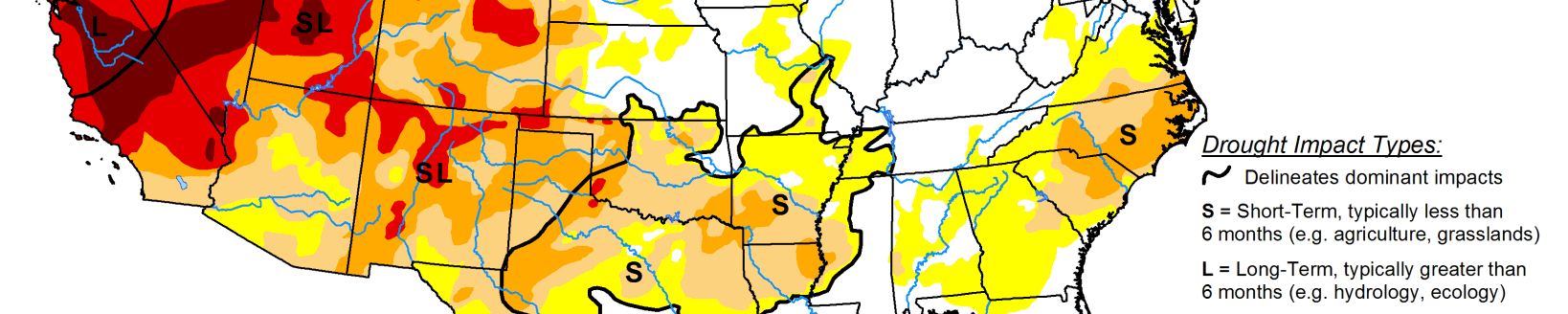
Drought conditions improve in Texas but intensify in other areas of the Plains
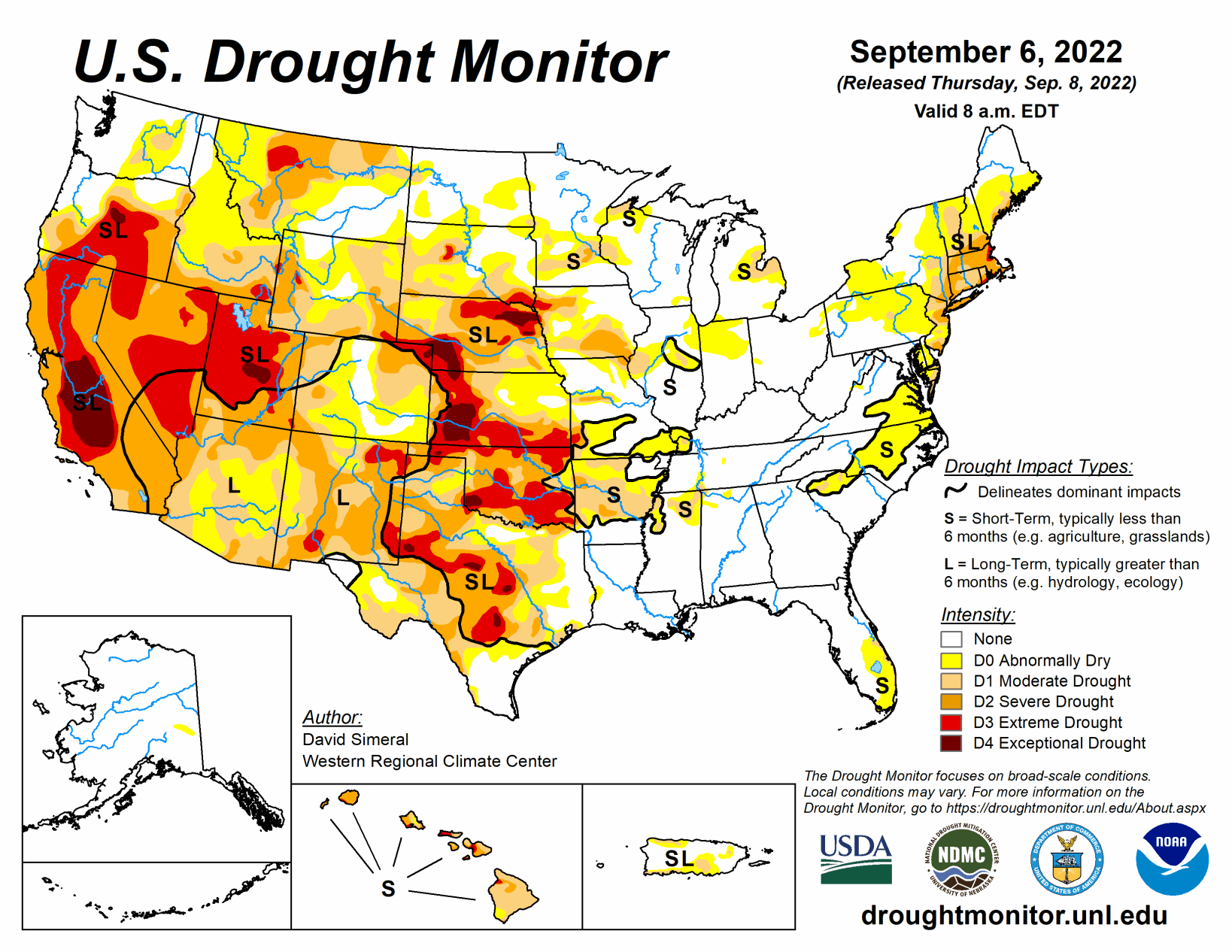
This U.S. Drought Monitor week saw continued improvements on the map across areas of the South, including Texas, in response to another round of localized heavy rainfall during the past week. Overall, the recent rainfall in Texas throughout the past month has started to make a significant dent in the state’s drought conditions in some areas.
In contrast, drought conditions intensified in areas of the central and northern Plains with additional degradations on this week’s map. In these areas, recent drought impact reports submitted to the National Drought Mitigation Center indicated drought-related impacts within the agricultural sector including reduced crop yields as well as deteriorating pasture and rangeland conditions.
Out West, the big story of the past week has been the heat wave that has impacted the region with record-setting temperatures and critical fire-weather conditions. In Death Valley, California, high temperatures exceeded 125 degrees F multiple times during the past week, including on Sept. 1 when the high temperature reached 127 F―potentially breaking the record for the hottest temperature ever recorded during September, according to preliminary reports.
In the Midwest, short-term precipitation deficits and declining soil moisture levels led to the expansion of areas of drought in northern Missouri and central Illinois.
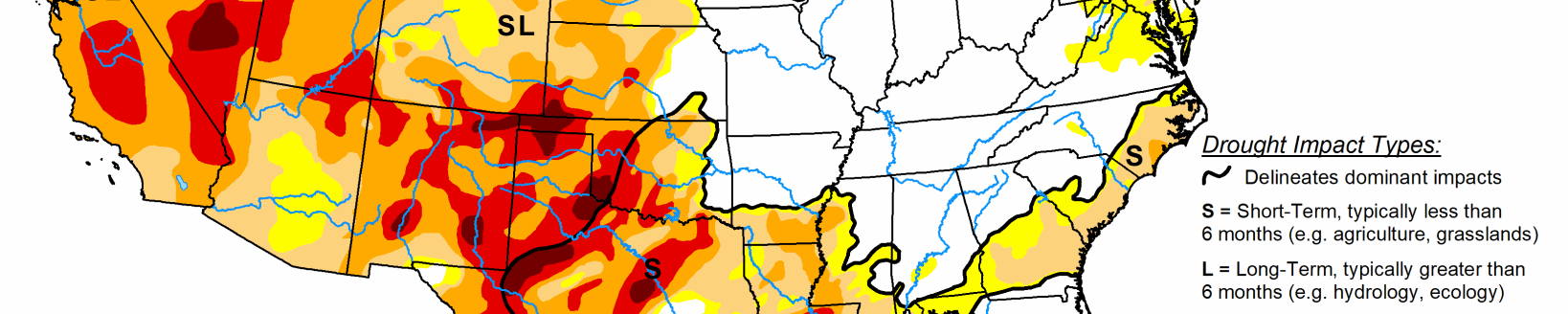
High Plains
On this week’s map, drought-related conditions continued to intensify across areas of southeastern Wyoming, northeastern Montana, Nebraska, southern South Dakota, and western Kansas, as anomalously hot temperatures impacted western portions of the region. According to the National Drought Mitigation Center’s Condition Monitoring Observer Reports, numerous drought impact reports have been submitted during the past 30-day period. Impacts include reduced crop yields, poor pasture conditions, and the need for supplemental feeding of livestock. The current drought situation was exacerbated by this week’s intense heat, with average maximum temperatures ranging from 95 to 100 degrees F in areas of eastern Montana, northern and eastern Wyoming, and western portions of South Dakota, Nebraska, and Kansas.
Midwest
For the week, light to moderate (1 to 5+ inches) rainfall accumulations were concentrated mainly across the Lower Midwest with the heaviest accumulations observed in southern portions of Missouri, Indiana, and Ohio. Areas of Moderate Drought (D1) and Severe Drought (D2) were reduced in southwestern Missouri. Conversely, short-term precipitation deficits (past 30-120 days) and negative soil moisture anomalies led to deterioration on the map in west-central Illinois and northeastern Missouri. Average temperatures for the week were above normal (ranging from 1 to 6 deg F) across much of the region, except for areas of southern Missouri, southern Illinois, and western Kentucky where temperatures were a few degrees below normal.
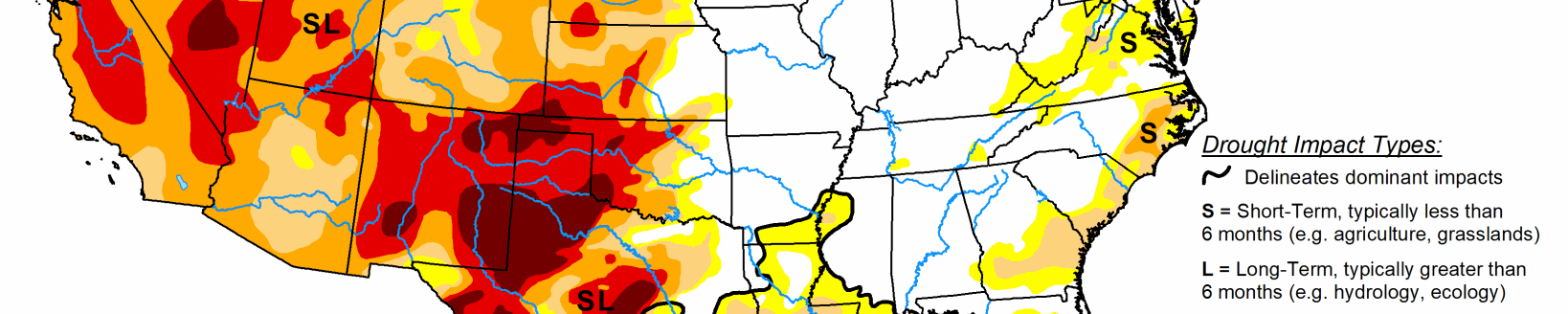
West
Out West, an anomalous upper-level ridge parked over the central Great Basin during the past week—leading to a dangerous heat wave and record-high temperatures across the region. The record heat exacerbated fire-weather conditions across Northern California, the Pacific Northwest, and the Northern Rockies as well as taxed California’s power grid in response to the record-high demand reported this week. Most of the region saw no precipitation this week, except for some isolated storm activity in western Washington, Arizona, eastern Colorado, and eastern New Mexico. On this week’s map, areas of drought expanded in southwestern and central Montana, and in northern Wyoming. Areas of Extreme Drought (D3) in the Four Corners region were trimmed back as part of a re-assessment of the impact of monsoonal rainfall during the past several months. Looking at reservoir storage conditions, the two largest reservoirs in the Colorado River system, Lake Mead and Lake Powell, are currently 28% and 24% full, respectively.
South
In the South, widespread improvements were made across Texas this week in response to another round of moderate-to-heavy rainfall that impacted isolated areas of the state, with accumulations ranging from 2 to 6+ inches. The recent rains have provided a much-needed boost to soil moisture and streamflow levels. Despite the recent rains, streamflow levels in some areas of the Hill Country have yet to recover, with gaging stations on numerous rivers and creeks reporting below-normal flows (ranging from the 2nd to the 24th percentile), according to the U.S. Geological Survey.
Elsewhere in the region, this week’s rainfall led to improvements in eastern Oklahoma, northern Arkansas, northern Mississippi, and western portions of Tennessee. For the past 30-day period, much of the region experienced above-normal precipitation with the greatest positive departures (ranging from 6 to 12+ inches) observed in the Basin and Range and southern portion of the Gulf Coastal Plains of Texas, northern Louisiana, and central Mississippi. Overall, average temperatures for the week were within a few degrees of normal, with larger negative departures (2 to 4 degrees F below normal) observed in western Texas.