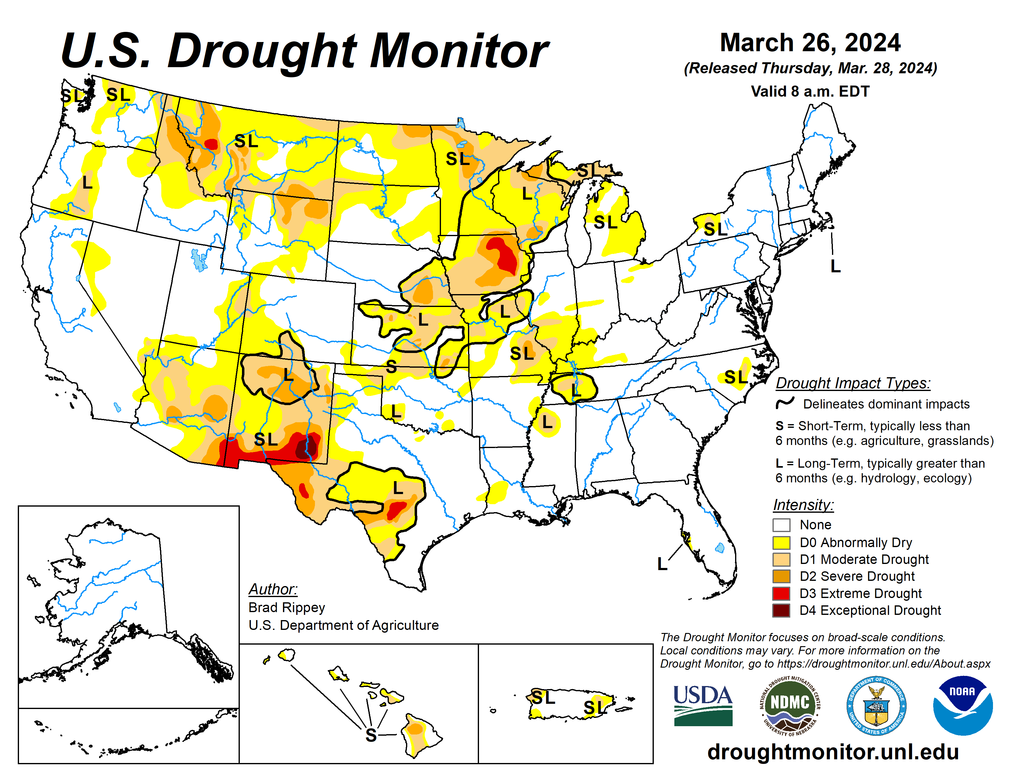
A winter-like storm system crossing the central Plains and upper Midwest resulted in a variety of weather hazards, including blizzard conditions, high winds, heavy rain, and locally severe thunderstorms.
That storm was preceded by a weaker system, which produced a stripe of snow from northern Montana into portions of the Great Lakes States. Combined, the two storms produced 40 to 50% of the season-to-date snowfall in four to five days at several upper Midwestern locations, including Eau Claire, Wisconsin, and Minneapolis-St. Paul, Minnesota.
Though the winter-like storm eventually weakened and drifted northward into Canada, impacts lingered. For example, the wettest day ever observed during March was noted on March 23 in mid-Atlantic locations such as Philadelphia, Pennsylvania, and New York’s LaGuardia and JFK Airports. Elsewhere, the West received widespread but generally light precipitation.
The U.S. Drought Monitor is jointly produced by the National Drought Mitigation Center at the University of Nebraska-Lincoln, the U.S. Department of Agriculture and the National Oceanic Atmospheric Administration. (Map courtesy of NDMC.)
South
Additional heavy showers further trimmed coverage of abnormal dryness and moderate to severe drought in the mid-South and western Gulf Coast region. In fact, severe drought (D2) was eliminated from Mississippi, while moderate drought was eradicated from Louisiana. Farther west; however, there was modest expansion of dryness and drought in northern and western sections of Oklahoma and Texas.
High winds raised dust in western Texas, where Lubbock clocked a southwesterly wind gust to 73 miles per hour and reported visibilities as low as 2 miles on March 24. The U.S. Department of Agriculture noted topsoil moisture was rated 44% very short to short in Texas, along with 27% in Oklahoma.
On the same date, 51% of the winter wheat in Texas was rated in good to excellent condition, along with 70% of the crop in Oklahoma.
Midwest
Heavy precipitation—rain and snow—brought some dramatic drought changes to the Midwest. The highest totals, 2 to 3 inches or more, bisected Missouri and covered portions of Iowa, Minnesota, and Wisconsin.
Where heavier precipitation fell but long-term issues such as groundwater shortages remained, the drought designation was changed from “SL” – both long- and short-term drought – to “L”. From March 21 to 24, snowfall totaled 14.3 inches in Eau Claire, Wisconsin, and 11.3 inches in Minneapolis-St. Paul, Minnesota.
Through March 20, season-to-date snowfall had totaled just 16.4 inches (34% of normal) in Eau Claire and 14.3 inches (31%) in Minneapolis-St. Paul. A large percentage of the Midwestern spring snow fell on March 24, when daily-record totals included 10 inches in Eau Claire and 8.2 inches in Minneapolis-St. Paul.
However, precipitation bypassed a few Midwestern areas, with those areas noting some slight expansion of abnormally dry conditions and moderate drought. On March 24, with precipitation underway, the USDA indicated that statewide topsoil moisture was rated more than 40% very short to short on March 24 in several Midwestern States, including Illinois (44%) and Missouri (42%).
High Plains
While much of the region experienced precipitation, including late-season snow, there were some targeted areas of expansion of abnormal dryness and moderate drought, especially in southern Kansas.
General reductions in the coverage of D0 and moderate to severe drought were observed in several areas, including parts of the Dakotas, northern Kansas, and eastern sections of Montana and Nebraska. According to the USDA, topsoil was rated more than 40% very short to short on March 24 in Wyoming (55%), North Dakota (49%), South Dakota (47%), Nebraska (47%), Kansas (45%).
West
Drought changes were mostly minor, although a reassessment of season-to-date precipitation and conditions led to some drought improvement being depicted in parts of New Mexico.
Approaching the traditional Western peak snowpack date of April 1, snow-water equivalencies were mostly near or above average, except in much of Montana, Washington, northern Idaho, and northeastern Wyoming. Those low snowpack numbers were reflected in ongoing moderate to extreme drought in the northern Rockies and environs.
Looking ahead
Rain will linger along the Atlantic Coast through Thursday, with parts of interior New England experiencing a rain-to-snow transition on Friday. Farther west, Pacific storminess will initially affect the northern half of the western United States. By Friday, however, the focus for stormy weather will shift into California.
During the weekend, precipitation will spread farther inland across the Great Basin, Intermountain West, and parts of the Southwest. Early next week, precipitation will return across the nation’s mid-section, initially extending eastward from Colorado and Wyoming.
The National Weather Service’s 6- to 10-day outlook for April 2 to 6 calls for the likelihood of near- or below-normal temperatures nationwide, except for warmer-than-normal weather in California, the Great Basin, northern New England, and southern Florida.
Meanwhile, near- or above-normal precipitation across much of the country should contrast with drier-than-normal conditions in coastal sections of Oregon and northern California, as well as a broad area covering much of the eastern Plains, mid-South, and Midwest.
The U.S. Drought Monitor is jointly produced by the National Drought Mitigation Center at the University of Nebraska-Lincoln, the U.S. Department of Agriculture and the National Oceanic Atmospheric Administration. (Map courtesy of NDMC.)
Brad Rippey is with the U.S. Department of Agriculture.
Related Articles


