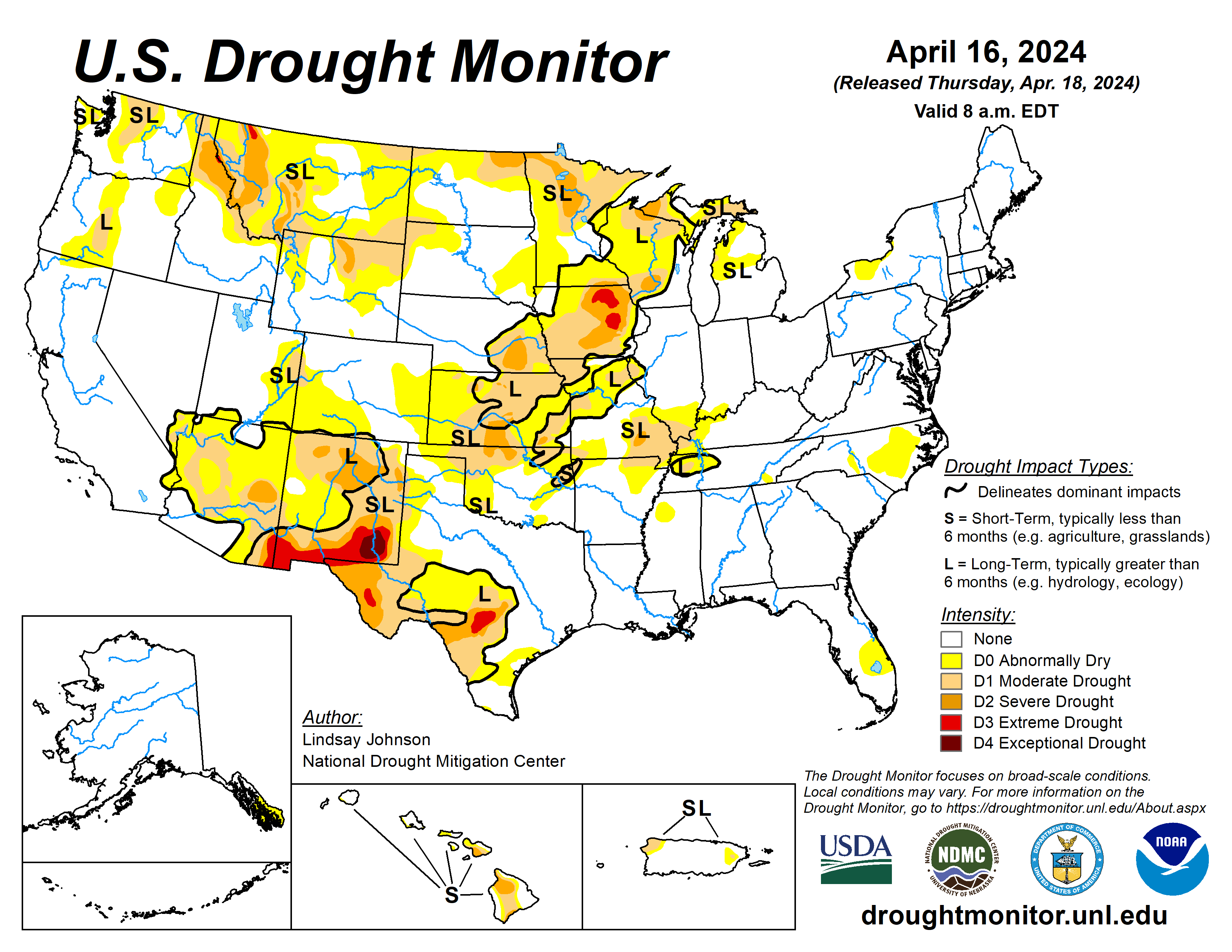
Heavy precipitation fell across much of the central and eastern parts of the country, bringing improvements along the Mississippi River and Great Lakes regions. There were also isolated areas of improvement in Oregon, Idaho and Montana.
Extreme drought conditions were introduced in the mountainous region along the Idaho and Montana border due to concerns about low snow amounts and possible early snowmelt. Across the country in the Southeast, areas in North Carolina and southern Florida are seeing drying conditions due to low precipitation over the past few weeks.
Western and southern Texas, which largely missed this week’s precipitation, saw an expansion of abnormal dryness, moderate and severe drought conditions. Flash drought conditions are appearing in Oklahoma, and Kansas, with some spillovers in eastern Colorado and western Missouri. Weeks with little precipitation, warming temperatures, dry soils and low streamflow levels, are leading to rapid degradation.
The U.S. Drought Monitor is jointly produced by the National Drought Mitigation Center at the University of Nebraska-Lincoln, the U.S. Department of Agriculture and the National Oceanic Atmospheric Administration. (Map courtesy of NDMC.)
South
Heavy precipitation fell across eastern Texas, Louisiana, southern Arkansas and west-central Mississippi. This brought improvements in northeast Mississippi, leaving the state drought-free with only some lingering abnormally dry conditions.
While less precipitation fell in Tennessee, the western part of the state also saw improvements. Conversely, southern Texas and Oklahoma are seeing conditions worsen as conditions continue to quickly deteriorate. Conditions in Oklahoma into Kansas are seeing rapid degradation and short-term dryness indicating flash drought conditions.
Midwest
Conditions across the Midwest continued to improve, except for western Missouri and a small area in western Michigan. The central and eastern parts of the Midwest received 1 to 2.5 inches of rain, bringing improvements to Missouri, Illinois, Indiana and the Kentucky border.
Eastern Iowa also saw slight improvements due to improved conditions over the past 30 to 90 days, though longer-term conditions of six months or more are still showing dryness. Western Missouri missed out on the precipitation, further degrading already dry conditions similar to Kansas and Oklahoma.
High Plains
The southern High Plains are in the grips of rapidly drying conditions, leading to degradations across Kansas, with conditions bleeding into eastern Colorado and southern Nebraska. Western Kansas has not seen precipitation in over two weeks, providing no relief to the rapidly drying soils and low streamflows.
Conditions in Kansas into Oklahoma are seeing rapid deterioration and short-term dryness indicating flash drought conditions.
West
The West saw conditions remain mostly the same, with areas in the Northwest seeing some improvements. Regions along the Pacific coast received some precipitation but not in areas needing moisture. There was some improvement in southern Oregon where precipitation did fall.
Southern Idaho also saw improvement with the precipitation and decent snowpack. Northern Idaho into Montana did see some degradation, with mountainous areas seeing snow at extremely low levels. Western Montana experienced improvements in the east-central part of the state.
Looking ahead
More heavy precipitation is expected in the Plains and Midwest is forecat for April 19 5o 23. Iowa, Nebraska and South Dakota could see upwards of 2.5 inches of precipitation. Northeast Texas, southeastern Oklahoma, and western Arkansas could see 1.5 to 2 inches of precipitation. Areas of higher elevation in the Rockies of Colorado and Wyoming are also expected to see between 1 to 2 inches.
The National Weather Service Climate Prediction Center’s 6- to10-day outlook (starting April 22) favors above-normal precipitation for southern parts of the U.S., particularly along the eastern Gulf Coast from Texas and Louisiana into parts of Arkansas and Oklahoma. Florida is also favoring above-normal precipitation.
The Northwest and Northeast are leaning toward below-normal precipitation. From the middle of Pennsylvania northward, below-normal precipitation is likely to occur. In terms of the temperature outlook, above-normal temperatures are expected from the West into the High Plains, as well as along the Gulf Coast and Florida.
Utah, Nevada, northern Arizona, northern New Mexico and western Colorado are showing a 70 to 80% likelihood of above-normal temperatures. Eastern Alaska is also leaning towards above-normal temperatures. The Mid-Atlantic region and the eastern Midwest are leaning toward below-normal temperatures.
Lindsay Johnson is with the National Drought Mitigation Center.
Related Articles


