Much of High Plains in need of moisture
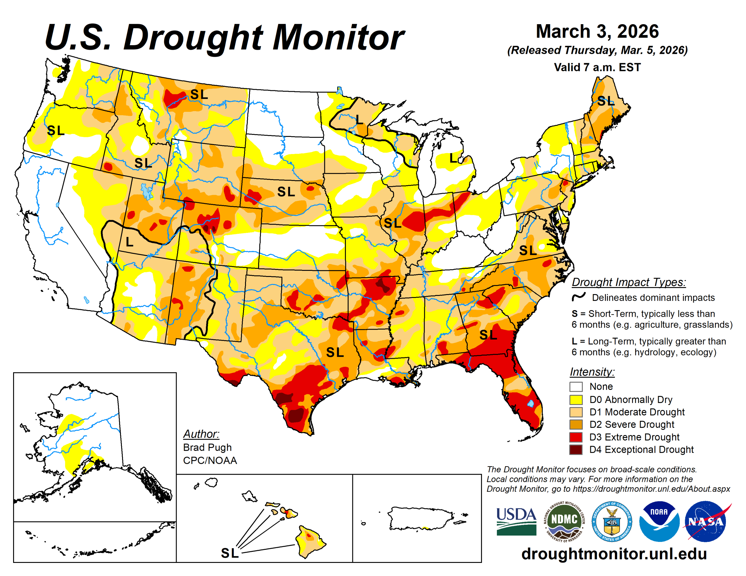
Since the beginning of December 2025, drought expanded and intensified across the lower Mississippi Valley and southern Great Plains, which is typical during a La Nina winter.
Much needed precipitation at the end of February led to small improvements across parts of the Southeast and also at least briefly stabilized the drought status for this region. Widespread severe to extreme drought is designated for much of the Carolinas, Georgia, southeastern Alabama, and Florida.
A longer-term drought continues to affect the Mid-Atlantic and portions of the Northeast. The unusually dry winter persisted across the Midwest through the end of February with additional degradations made this past week.
These worsening drought conditions extend west to the central Great Plains along with the central to northern Rockies. Below-normal snowpack remains a major concern for the West heading into the spring.
The U.S. Drought Monitor is jointly produced by the National Drought Mitigation Center at the University of Nebraska-Lincoln, the U.S. Department of Agriculture and the National Oceanic Atmospheric Administration. (Map courtesy of NDMC.)
South
Since the beginning of December, precipitation has averaged less than 50% of normal across much of the lower Mississippi Valley and southern Great Plains.
Impact reports from north-central Oklahoma include poor wheat conditions and surface water supply shortages. An expansion of moderate drought was also warranted for northeastern New Mexico. In addition to the drier-than-normal winter, 90-day temperatures have averaged 2 to 6 degrees Fahrenheit above normal.
The lack of winter precipitation combined with periods of unseasonably warm temperatures and enhanced winds led to an increasing coverage of severe to extreme drought from the Mississippi River west through Oklahoma and Texas.
Midwest
Drought continued to expand and intensify across the Ohio Valley through the beginning of March. The 90-day precipitation averaging less than half of normal across western Kentucky, southeastern Missouri, and much of Indiana and Illinois.
Paducah, Kentucky and Carbondale, Illinois had their driest meteorological winter (Dec. 1, 2025 to Feb. 28, 2026) on record. Drought initially over the central Great Plains has recently overspread northwestern Iowa and southwestern Minnesota.
Despite widespread precipitation amounts of 0.5 to 1.5 inches across central to southern Missouri from February 24 to March 2, little to no change was warranted for those areas.
High Plains
Although late winter is a relatively dry time of year across the Central Great Plains, periods of unseasonably warm temperatures and enhanced winds this past month led to intensifying drought across northeastern Colorado and Nebraska.
The 30-day temperatures averaged 6 to 10 degrees above normal throughout the Great Plains. A 1-category degradation was made this past week to parts of Kansas and South Dakota.
Widespread drought of varying intensity remains designated for much of Colorado and Wyoming. As of March 3, snow water equivalent is less than 70% of normal across the central Rockies.
West
Water-year-to-date precipitation (Oct. 1, 2025 to March 2, 2026) averaged below-normal for the Great Basin which led to a slight increase in moderate (D1) coverage across northeastern Nevada.
Following a drier- and warmer-than-normal February, a 1-category degradation was also made to parts of Montana. A 1-category degradation was also warranted for parts of Idaho, reflecting the below-normal precipitation and low snowpack this past winter.
Even for areas of the West that have received above-normal precipitation since the beginning of Oct. 1 such as the Northern Intermountain West and Northern Cascades of Washington, snow water equivalent is running below normal.
The low snowpack throughout much of the West is a major concern heading into the spring. As of March 3, SWE is less than 50%v of normal from the Cascades of the Pacific Northwest southward through the Great Basin and Four Corners region. Although California remains drought-free, SWE is 59% of normal statewide according to the California Department of Water Resources.
Looking ahead
A major pattern change is underway which will promote multiple low-pressure systems tracking across the Great Plains and Midwest during early to mid-March.
The Weather Prediction Center (valid March 5 to 9) depicts a swath of heavy precipitation (1 to 3 inches, locally more) from eastern Texas and southeastern Oklahoma northeast through the lower to middle Mississippi and Ohio Valleys.
Much-needed snowfall is expected across the northern to central Rockies, while dry weather prevails across California and the Southwest. Much above-normal temperatures are forecast across the southeastern and central U.S. where daily record highs may be broken from March 5 to 9.
The National Weather Service’s 6- to 10-day outlook (valid March 10 to 14) calls for an increased chance of above-normal temperatures for the East, Middle to Lower Mississippi Valley, southern Great Plains, Southwest, and California. Below-normal temperatures are more likely from the Pacific Northwest east to the northern Great Plains.
The 6- to 10-day outlook favors above-normal precipitation from the Mississippi Valley to the East Coast. Above-normal precipitation probabilities decrease west across the Great Plains. Above-normal precipitation is also favored for the Pacific Northwest and northern Rockies.
Brad Pugh is with the National Oceanic Atmospheric Administration and Climate Prediction Center.


