Highly variable weather pattern dominates week
During the week, a highly variable weather pattern brought wide temperature swings to much of the contiguous United States.
An unusually cold airmass that had settled over the Plains at the start of the week pushed eastward, bringing a rapid and stormy end to the early season heat wave across the Eastern Seaboard. In contrast, the West baked under much above normal temperatures.
By mid-week, much above-normal temperatures had returned to the Plains, with daily maximum temperatures climbing into the upper 90s in some locations. As temperatures began to rebound across the East, cooler air overspread the Pacific states by the end of the week.
The strong temperature gradients that set up across the nation, coupled with ample Gulf moisture streaming northward resulted in widespread heavy and persistent precipitation, with many locations exceeding two inches from eastern Texas and Oklahoma northeastward to the mid-Atlantic states, and isolated instances of 6 or more inches in some spots.
Widespread rainfall, albeit with lighter accumulations, fell across the north-central Plains as daily temperatures warmed, but mostly dry weather prevailed across the upper Mississippi Valley and western Corn Belt. West of the Rockies, mostly dry weather prevailed for most of the week, but showers associated with a strong cold front overspread the Northwest at the very end of the period.
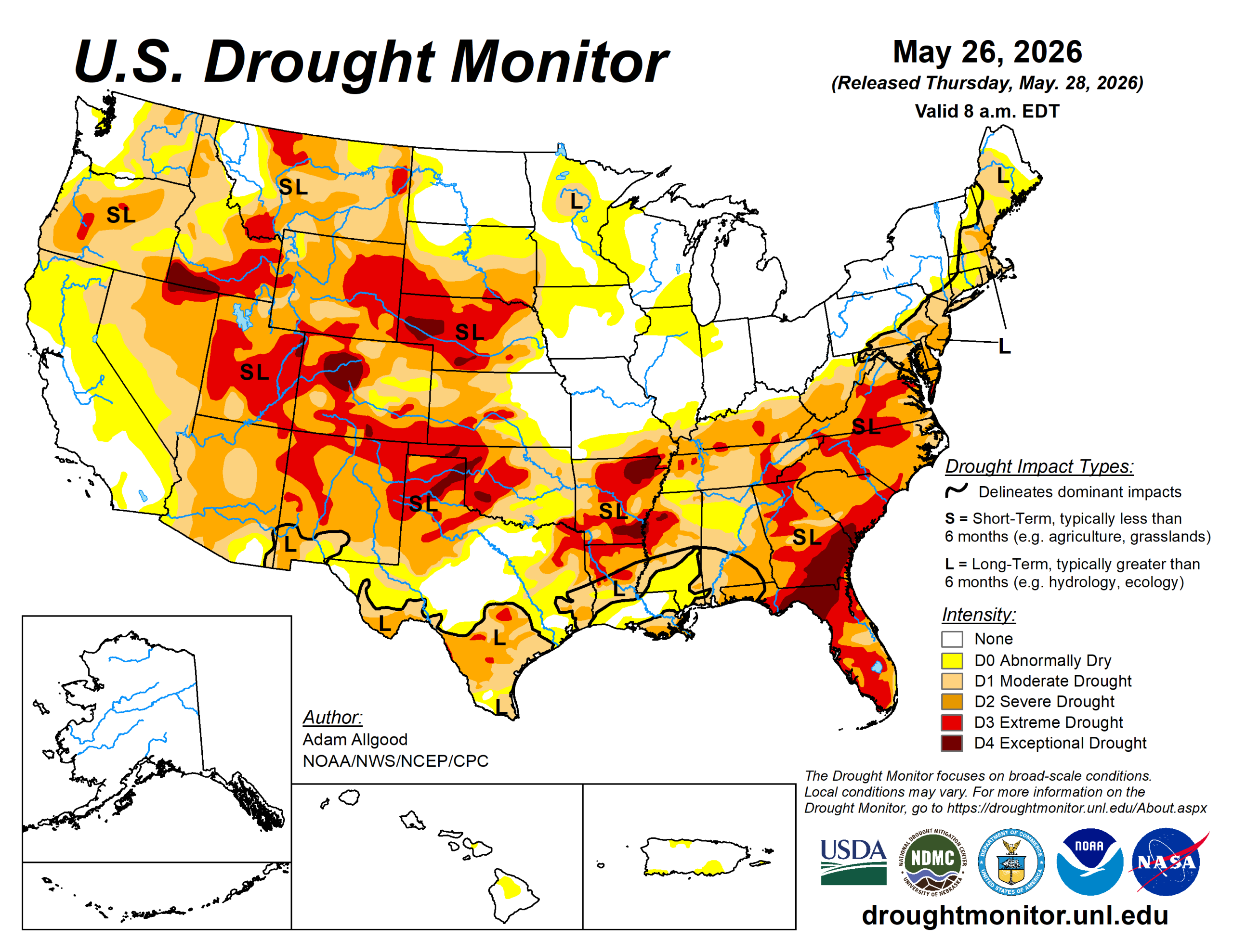
The U.S. Drought Monitor is jointly produced by the National Drought Mitigation Center at the University of Nebraska-Lincoln, the U.S. Department of Agriculture and the National Oceanic Atmospheric Administration. (Map courtesy of NDMC.)
South
Widespread heavy rainfall overspread the southern region, with amounts increasing from west to east. Rainfall was locally heavy, but a bit spottier across Arkansas, which also saw widespread drought reduction, but with less coverage. Across Texas, heavy rainfall across the eastern half of the state yielded drought improvements and also localized flooding.
Across north Texas, localized convection brought relief to some areas, but hot conditions resulted in degradation where precipitation did not occur.
Midwest
Another mostly dry week across the northern Mississippi Valley and western Corn Belt exacerbated short term dryness, with reports of browning grass and increased irrigation across the region, though longer term drought indicators remain favorable.
Due to these short term impacts, abnormal dryness was introduced to northeastern Iowa, and along the Mississippi headwaters region.
High Plains
As below-normal temperatures transitioned back to a hot pattern across the High Plains, widespread precipitation moved through the region.
Areas of convection brought up to 2 inches of rain to portions of eastern Nebraska and eastern Colorado, while amounts were generally an inch or less elsewhere. This precipitation was sufficient to bring some drought reduction across northern and northeastern Colorado, but drier conditions across southeastern Colorado and Kansas, coupled with hot temperatures, resulted in degradation.
A sharp cutoff in precipitation was also noted across the far western Dakotas, where small areas of degradation were noted along the borders with Wyoming and Montana.
West
Mostly dry weather and above-normal temperatures dominated the western region during the week sparking some small-scale degradation across Montana and New Mexico, where the effects of the meager winter snow cover are beginning to be felt in falling streamflow values.
Status quo was maintained west of the Rockies for the most part, as reservoir conditions remain good across California during a climatologically dry time of year. At the end of the week, a strong cold front brought abnormal moisture to the Northwest and northern Rockies. While not sufficient to substantively alter the drought depiction, a modest reduction in abnormal dryness was noted in far northwestern Washington.
Looking ahead
During the upcoming week, a late season storm system across the West is forecast to bring abnormal moisture to California, Oregon, and Washington, with precipitation spreading eastward to the northern Rockies by mid-week.
The heaviest accumulations are forecast across the southern Cascades. Periods of convection are favored across the Plains states throughout the week, with the WPC 7-day quantitative precipitation outlook showing a potential for 1 inch or locally more across portions of Nebraska and Kansas, where Gulf moisture advection is most pronounced.
Across the eastern third of the contiguous United States, unsettled weather is favored to continue across the Southeast, with the focus of heaviest precipitation shifting toward Florida and the south Atlantic coastal plain. A slow-moving cold front is forecast to push east during the period, maintaining showery weather across the Deep South while cooler and drier conditions overspread the Corn Belt and Northeast.
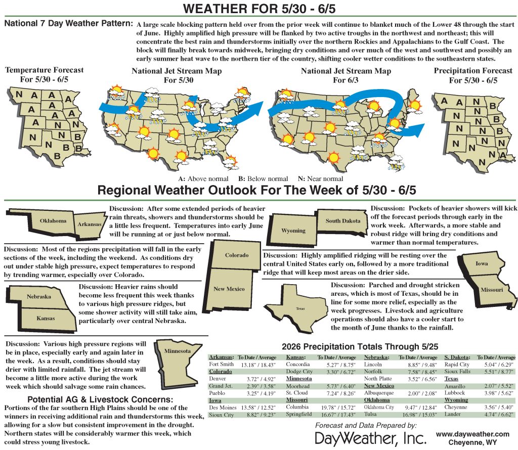
During Week-2, the trough over the East is favored to rapidly de-amplify, with temperatures quickly moderating. Above-normal temperatures are favored across the West and northern tier of the CONUS on the latest CPC 8- to 14-day outlook, with mostly near-normal temperatures the most likely outcome across the South and Southeast regions.
Unsettled weather and continued precipitation may play a role in keeping hot weather at bay across the southern tier. The CPC’s 8- to 14-day precipitation outlook favors above-normal precipitation across the Four Corners states eastward along the southern tier to the Atlantic coastline as far north as Virginia.
Near normal precipitation is favored elsewhere, except for a small wet signal over the Pacific Northwest.
Adam Allgood is with NOAA/NWS/NCEP/CP.