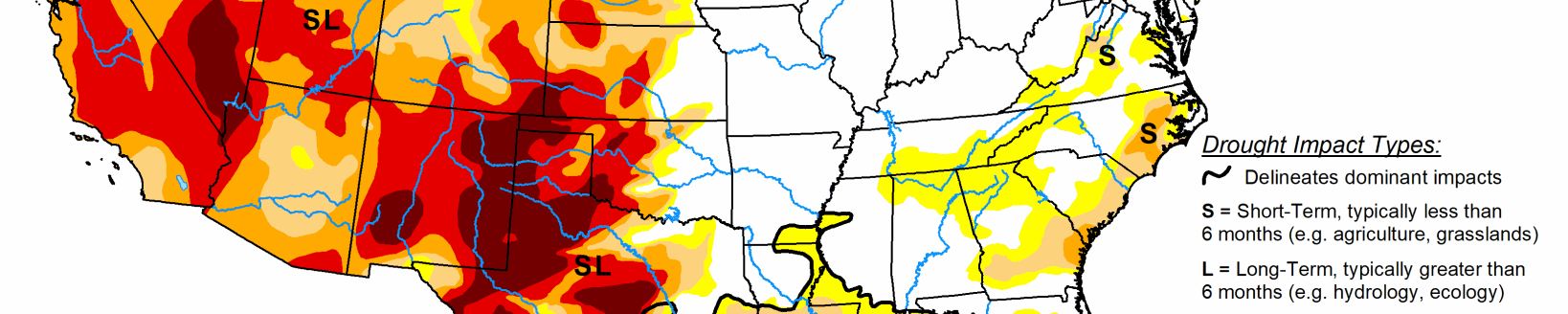
Little to no precipitation received in western High Plains to Dakotas
Pacific weather systems migrated across the contiguous U.S. in a fairly westerly jet stream flow during this U.S. Drought Monitor week. East of the Rockies, they tapped Gulf of Mexico moisture and dropped above-normal precipitation in a storm track that stretched from Texas to the Great Lakes.
The jet stream flow amplified as the week progressed, producing a strong trough over the eastern CONUS with a ridge migrating across the West into the central CONUS. Cold arctic air was directed by the trough into the East behind surface frontal low pressure systems. The Pacific fronts dropped precipitation along the coastal ranges, but the air masses quickly dried out as they crossed the interior West, resulting in below-normal precipitation from the High Plains west to the coastal ranges.
The Gulf of Mexico and Atlantic coasts were mostly drier than normal. Weekly temperatures were warmer than normal from Texas to the Mid-Atlantic, and colder than normal along the West Coast and northern to central Plains. Drought and abnormal dryness expanded across parts of the West, southern Plains and Gulf Coast, and Mid-Atlantic coast, but contracted in parts of the northern Rockies and southern to central Plains, as well as Hawaii and the Alaska panhandle.
High Plains
Half an inch or more of precipitation fell across parts of the eastern Dakotas and eastern Kansas, with less than half an inch westward. Very little to no precipitation occurred across large parts of the western High Plains from Colorado to the Dakotas. D0 was trimmed in parts of southern Nebraska and adjacent Kansas. But D0 expanded in northeast Colorado into adjacent Nebraska, and a spot of D0 was added in north central Wyoming.
Dry conditions were evident in northeast Colorado in many indices, especially SPI, SPEI, soil moisture, and groundwater indicators, and most notably at the 4-month time scale. Temperatures have been warmer than normal in this area, December was drier than normal, and very little precipitation has fallen in January. An area to watch is southeast Colorado, where reports note that winter wheat is suffering and soils are very dry, and evaporative demand (as measured by the Evaporative Drought Demand Index is high, indicating the occurrence of warm temperatures, low humidity, and higher winds.
South
Bands of 2+ inch precipitation occurred across parts of Texas into central Oklahoma, and from eastern Texas into Mississippi, with some reports exceeding 5 inches. Half an inch or more of precipitation surrounded these areas across the region. But some areas had less than half an inch, including parts of western, southern, and east-central Texas, western Oklahoma, southeast Louisiana, and parts of Arkansas.
For the dry areas, this week’s subnormal precipitation added to deficits stretching back 6 months or more. For the areas that were wet this week, the precipitation helped with short-term deficits, but longer-term deficits remained and were especially still severe at the 6-month time frame. The D2 in southwest Oklahoma was eliminated and its surrounding D0-D1 contracted. D0-D3 was contracted in the wet areas of Texas, but D0-D2 expanded in the dry areas. D0-D1 contracted in northwest Louisiana into adjacent Texas. Three-month precipitation deficits prompted expansion of D0 along the Louisiana coast into southern Mississippi.
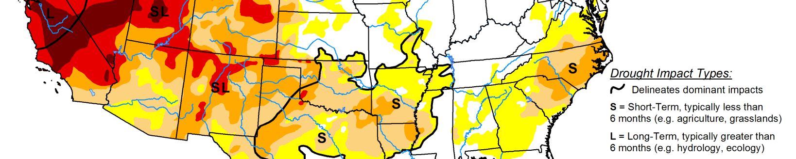
Midwest
Half an inch to an inch of precipitation fell almost region-wide this week. Only Kentucky and a few areas of Iowa, Minnesota, and Wisconsin had less than half an inch. A strip of 1 to over 2 inches of precipitation was measured across Missouri and Illinois. Soils were wet across most of the Midwest, except parts of Ohio, and precipitation was above normal in most areas at most time scales from the last week to 12 months. There was no drought or abnormal dryness in the Midwest this week.
Related Articles