Open weather across much of the country favored summer crop maturation and fieldwork, including harvest efforts and winter wheat planting. By Sept. 12, more than one-third (37%) of the U.S. corn was fully mature, while 38% of the soybeans were dropping leaves, versus respective 5-year averages of 31% and 29%. Meanwhile, among the 13 major production states that have planted some winter wheat, all except Oregon were at or ahead of the 5-year average pace. Oregon’s delay—4% planted, versus 7% on average—can be attributed to producers’ hesitancy to sow winter wheat due to drought. Rain was observed, however, in several regions, including parts of the South and East.
Portions of the Gulf Coast region had to contend with Hurricane Nicholas, the eighth Atlantic Basin tropical cyclone to make a U.S. landfall in 2021. Nicholas, briefly a Category 1 hurricane, moved ashore on Texas’ Matagorda Peninsula around 12:30 a.m. CDT on Sept. 14, delivering heavy rain and gusty winds to the middle and upper Texas coast. Aside from the western Gulf Coast region, some of the heaviest rain (locally 4 inches or more) fell in northern New England, chipping away at lingering, long-term drought. Elsewhere, fleeting showers dampened some of the driest areas of the West, temporarily aiding wildfire containment efforts. However, hot, dry weather soon returned across the West, limiting the overall benefit of the precipitation. In fact, temperatures broadly averaged above normal across the western half of the country.
South
While former Hurricane Nicholas soaked the western Gulf Coast region, many of parts of the South continued to experience short-term drying. As a result, abnormal dryness (D0) broadly expanded across Arkansas, Oklahoma, and Texas, extending into northwestern Mississippi and western Tennessee. Pockets of moderate drought (D1) also developed. By Sept. 12, Arkansas led the region—according to the U.S. Department of Agriculture—with topsoil moisture rated 69% very short to short, followed by Oklahoma (60%) and Texas (59%). At times, heat has been a factor in rapidly worsening conditions. In Texas, Borger posted a high temperature of 106 degrees F on the 10th, edging the monthly record of 105 F originally set on Sept. 5, 1995. Elsewhere in Texas, Del Rio noted highs of 100°F or greater on each of the first 10 days in September.
Midwest
Short-term dryness (D0) has begun to expand across southern and eastern sections of the region, favoring summer crop maturation but reducing topsoil moisture. Meanwhile, long-term drought issues persisted across the upper Midwest, despite some recent rainfall. By Sept. 12, the U.S. Department of Agriculture reported that topsoil moisture was at least one-third very short to short in each Midwestern State except Wisconsin, led by Indiana (47%). During the week ending Sept. 12, very short to short values increased by more than 10 percentage points in Indiana and Ohio. In contrast, locally heavy rain was observed in the Great Lakes region, particularly across portions of Michigan and Wisconsin. Elsewhere, lingering impacts from summer drought left 63% of Minnesota’s pastures in very poor to poor condition on Sept. 12.
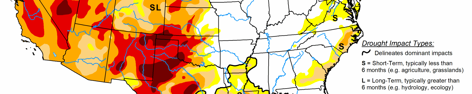
High Plains
Short-term dryness and drought has become more apparent in recent weeks across the southern section of the region, including parts of Kansas and Colorado, aggravated by periods of late-summer heat. A monthly record of 89°F was tied on Sept. 10 in Alamosa, Colorado. Alamosa again reached 89°F on Sept. 11, tying the record first set on Sept. 5 and 6, 2020, while Colorado Springs, Colorado, achieved a new September standard (98 F; previously, 97 F on Sept. 6, 2020). Across the High Plains, Sept. 10-11 featured consecutive triple-digit, daily-record highs in communities such as McCook, Nebraska (102 and 104 F); Goodland, Kansas (103 and 102 F); and Burlington, Colorado (101 and 100 F). Dodge City, Kansas (105 F on the 11th), achieved a 105-degree reading in September for only the third time on record, following 106 F on Sept. 3, 1947, and 107 F on Sept.1, 2011.
Farther north, there were some adjustments (mostly improvements) to the drought depiction, primarily in the Dakotas, based on favorable impacts from recent rain events. For example, improvements in topsoil moisture have led to some greening of drought-affected pastures and have encouraged winter wheat producers to begin planting. Still, the U.S. Department of Agriculture reported on Sept. 12 that topsoil moisture was 64% to 71% very short to short in the Dakotas, while rangeland and pastures were rated 77% to 80% very poor to poor, reflecting the long road ahead regarding drought recovery. On the same date, statewide topsoil moisture on the High Plains ranged from 39% very short to short in Nebraska to 79% in Wyoming.
West
Any benefit from patchy rainfall across northern California and the interior Northwest was largely offset by above-normal temperatures. Still, with rainfall totaling 0.37 inch on Sept. 10, Redding, California, experienced its wettest day since April 25, when 0.39 inch fell. Record-setting rainfall totals for Sept. 10 included 0.63 inch in Ephrata, Washington; 0.61 inch in Redmond, Oregon; and 0.26 inch in Red Bluff, California. Most areas of the West had no change in the drought depiction; however, changes in the Northwest were a mix of slight improvement and minor degradation, mostly due to assessment of earlier precipitation events, water-supply reports, and vegetation health.
Preliminary reports indicated that statewide reservoir holdings were less than one-half of the end-of-August average in Nevada, New Mexico, and Oregon. Meanwhile, several dangerous wildfires remained active across northern California and the Northwest.
Related Articles