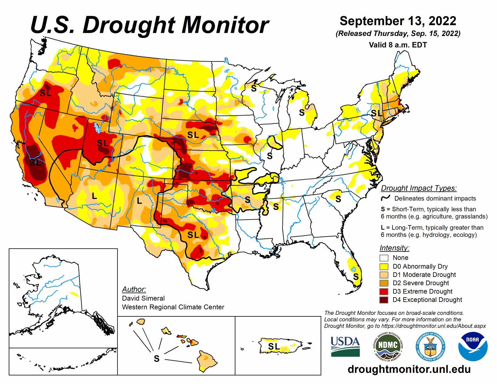
This U.S. Drought Monitor week saw areas of isolated heavy rainfall in Southern California and the Desert Southwest in association with remnant moisture from Tropical Cyclone Kay late last week. Over the weekend and early this week, the residual moisture from the system moved further onshore impacting areas including Southern California, southern Sierra Nevada, Desert Southwest, and portions of the Great Basin.
In the High Plains, above-normal temperatures (2 to 6 degrees F) and generally dry conditions during the past week continued to exacerbate drought conditions across areas of the central and northern Plains, with a growing number of drought impacts within the agricultural sector being reported to the National Drought Mitigation Center.
In Texas, areas of isolated heavy rainfall accumulations (3 to 5+ inches) this week continued to ease drought-related conditions in the Rio Grande Valley and South Texas. In the Midwest, widespread heavy rainfall accumulations ranging from 2 to 6+ inches impacted northern Illinois and southern Wisconsin over the weekend—erasing some of the short-term precipitation deficits.
Elsewhere in the region, a combination of short and longer-term precipitation deficits in Iowa led to degradation on the map, with rainfall deficits during the past 90-day period ranging from 4 to 8+ inches in southern Iowa.
Average minimum temperatures nationwide for August (+3.20 degrees F) and the July-August (+3.12 degrees F) periods were the warmest on record, according to NOAA National Centers for Environmental Information. Precipitation in the contiguous U.S. during August and the July-August 2022 period ranked at 19th and 28th wettest, respectively, placing it in the top 1/3rd wettest.
South
In the South, improvements were made across isolated areas of Mississippi, Tennessee, and Texas. Degradations were made on the map in areas of Oklahoma, where rainfall deficits during the past 90-day period ranged from -3 to -7+ inches. According to the Oklahoma Mesonet, the last 90-days were the 7th driest statewide with a -4.79-inch departure from normal (50% of normal). During the past week, rainfall accumulations across the region were generally light (
Midwest
For the week, light rainfall (1 to 2+ inches) accumulations were observed across much of the region with some heavy rainfall (3 to 6+ inches) amounts across southern Wisconsin and northern Illinois. On the map, some minor improvements were made in areas of Abnormally Dry (D0) in northern portions of Indiana and Illinois, while degradations occurred in Iowa and Minnesota. In Iowa, precipitation has been below normal during the past 90-day period, with anomalously dry topsoil conditions showing up on the latest NASA SPoRT soil moisture percentile rankings maps. Moreover, numerous rivers and creeks were showing below-normal flows across the state, according to the U.S. Geological Survey. According to reports from the Iowa State University Extension, the rainfall shortfalls in southern Iowa were likely to reduce yields for soybeans while corn test weights were lower. Average temperatures for the week were above normal (ranging from 1 to 4 degrees F) across much of the region.
High Plains
On this week’s map, degradations were made in areas of Kansas, Nebraska, South Dakota, and North Dakota in response to continued dryness, decreased soil moisture, poor pasture and rangeland conditions, and impacts to dryland crops. In Kansas and Nebraska, the latest 7-day streamflow levels were showing widespread well-below-normal flows, especially in Nebraska. In southern Nebraska, numerous gaging stations on rivers and creeks were observing flows in the 1st to 2nd percentile range, according to the U.S. Geological Survey. For the week, average temperatures were above normal in the Dakotas (1 to 4 degrees F) while Nebraska, eastern Wyoming, and Kansas were near normal to slightly below normal. According to NOAA NCEI, the Great Plains Region saw its 5th warmest (+2.7 degrees F) and 19th driest June-August on record. Statewide, Nebraska experienced its third driest June-August as well as its second driest August on record.
West
Out West, numerous large wildland fires are currently burning across areas of California, Oregon, and Idaho causing evacuations, damage to structures, and reduced air quality. On this week’s map, some improvements were made in southeastern California, southern Nevada, and New Mexico in response to rainfall this week associated with residual moisture from Tropical Cyclone Kay as well as the overall impact of this summer’s monsoonal rainfall that has helped improve short-term meteorological drought conditions and vegetation health.
Elsewhere in the region, a combination of short and long-term dryness, low streamflow, and declining soil moisture led to intensification of drought in areas of Montana and Idaho. For the week, average temperatures were 2 to 10+ degrees above normal across California, the Great Basin, northern portions of Arizona and New Mexico, and portions of the Pacific Northwest. Conversely, cloud cover associated with the remnants of Kay reduced daytime heating in the southeastern deserts of California and southern portions of Arizona and New Mexico, where average temperatures were 2 to 6 degrees below normal.
According to NOAA NCEI, the June-August 2022 period was the 3rd warmest on record for the West Climate Region, which includes California and Nevada. Additionally, in terms of average minimum temperatures, both August (+5.6 deg F) and the July-August (+4.8 deg F) periods were the warmest on record. Looking at precipitation, it was the 8th wettest August on record for the West Climate Region and the driest (-6.95 inches) January-August period on record. For the Southwest Climate Region, it was the 7th wettest June-August period on record and the 7th warmest for the contemporaneous period. In the Northwest Climate Region, August (+6.2 deg F) and the July-August (+5.3 deg F) period were the warmest on record.
Related Articles