Beneficial rain intermingled with drought
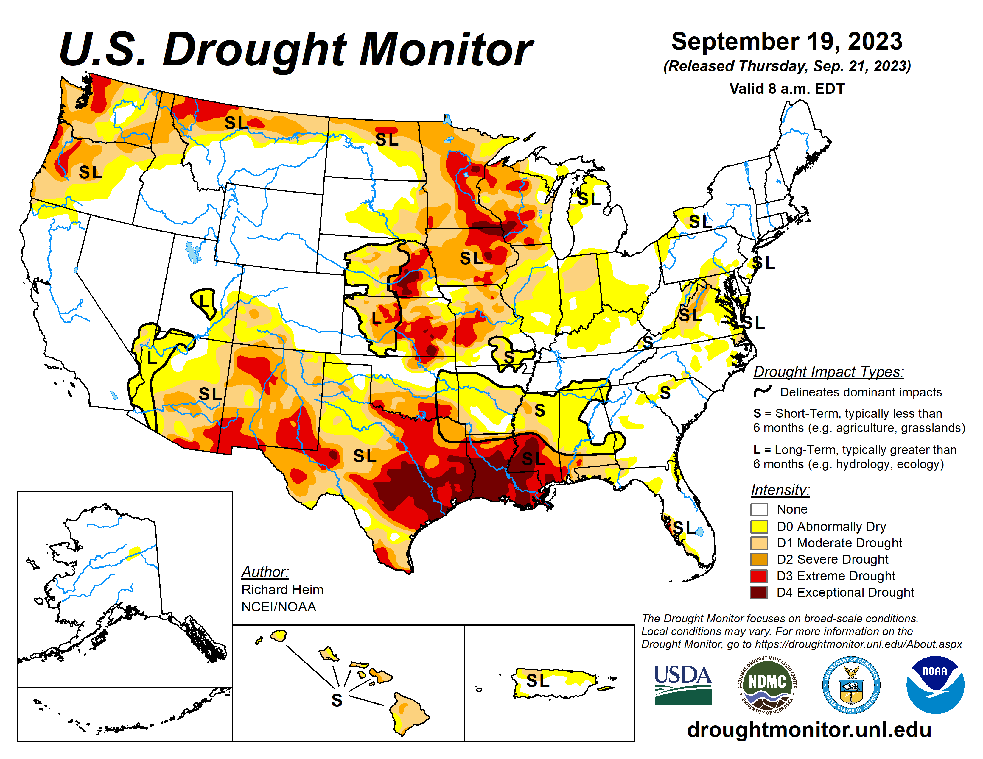
Several Pacific weather systems moved through the jet-stream flow during this U.S. Drought Monitor week of Sept. 13 to 19. The upper-level circulation still consisted of an upper-level ridge over the western contiguous United States but it was weakened by the traversing Pacific weather systems.
The ridge kept most of the western U.S. dry with warmer-than-normal temperatures from northern California to Montana. Cold fronts and surface low-pressure systems, that accompanied the weather systems, brought rain to the Southwest, southern Plains, Southeast, and Northeast. Heavy rain fell across western to central Texas, improving drought conditions.
The fronts kept temperatures cooler than normal from the Southwest to most of the southern Plains and across much of the country from the Mississippi River to East Coast. The northern Plains and parts of the central Plains, the Great Lakes, and the Mississippi and Ohio Valleys had a drier-than-normal week.
The dryness this week was a continuation of dry conditions that have lasted for several months—in some cases for years—across parts of the country and that have dried out soils across more than half of the CONUS. According to U.S. Department of Agriculture statistics, 58% of the nation’s topsoil moisture and 59% of the subsoil moisture was dry or very dry. For topsoil moisture, based on data going back to 2015, this amount is second only to the drought of 2022, which peaked at 68%.
A large part of Texas received over 2 inches of rain. These areas included western to central Texas and parts of the Southeast and Far South. Over 5 inches of rain was reported at stations near Lubbock, Austin, Houston, and Galveston Bay, with the CoCoRaHS station at Nassau Bay 0.9ENE reporting 9.57 inches.
The rain resulted in the contraction of D1-D4 in western to central Texas and in the southeast and far south sections of the state. Areas of half an inch to 2 inches of rain occurred over parts of western and southern Oklahoma. But most of Arkansas and Mississippi, parts of Louisiana and eastern Oklahoma, and much of the Rio Grande Valley were dry.
The compound effects of the excessive heat and dryness of the summer and early fall prompted expansion of abnormal dryness and moderate to exceptional drought in Mississippi, Louisiana, northeastern Texas, and southeast Oklahoma, with abnormal dryness and moderate drought expanding in Arkansas and eastern Oklahoma. The high evapotranspiration and lack of rain has dried out soils and resulted in impacts that include low or dry streams and cattle ponds, desiccated pasture and cropland, and stressed vegetation dropping leaves.
Reports include: hay and grasses are short and insufficient for cattle; soils are so dry that the ground is as hard as concrete. Reports like this are typical across the region. According to USDA reports, topsoil moisture is short or very short across 80% of Louisiana, 74% of Mississippi, 72% of Oklahoma, 69% of Arkansas, and 59% of Texas. The subsoil moisture statistics are: 87% Louisiana, 73% Oklahoma and Texas, 67% Mississippi, and 55% Arkansas. Over 60% of the pasture and rangeland is in poor to very poor condition in Texas (71%) and Louisiana (68%), and over 40% in Oklahoma (49%) and Mississippi (41%).
Showers associated with the cold fronts brought areas of rain to parts of Ohio and western parts of the Midwest region, with precipitation totals of half an inch or more. Locally 2 inches or more of rain fell in parts of northern Illinois and southern Wisconsin. But large parts of the region continued dry this week. Areas of drought and abnormal dryness were pulled back where the heaviest rains fell in northeast Minnesota and northern Illinois.
Continuing dry soils and the compounded effects of 6 months of below-normal precipitation and summer heat resulted in the expansion of moderate to exceptional drought in parts of the Upper Mississippi River Valley states, and abnormal dryness and drought in parts of the Ohio River Valley states. Low creeks and ponds and browning of crops and lawns have been reported in Indiana.
According to USDA statistics, topsoil moisture is short to very short across 79% of Iowa, 75% of Minnesota, 68% of Illinois, 64% of Wisconsin, 62% of Missouri, 56% of Indiana, and 43% of Ohio and Kentucky. The subsoil moisture statistics are: 80% Iowa, 76% Minnesota, 68% Wisconsin, 66% Illinois, 63% Missouri, 55% Indiana, and 42% Ohio. In Minnesota, 66% of the pasture and rangeland was in poor to very poor condition, with the statistics 48% for Iowa, 45% for Wisconsin, 44% for Missouri, and 41% for Illinois.
Half an inch to locally 2 inches of rain fell over western and southern parts of the High Plains region, mostly in Colorado, southern Kansas, and parts of Nebraska. But most of Wyoming, the Dakotas, Nebraska, and Kansas were dry this week. The rain trimmed D0 in southern Colorado and contracted D0-D1 in southwestern Kansas.
D0 and D3 expanded in eastern Kansas. D0 expanded in parts of southwest Nebraska, but the compounded effects of excessive summer heat and overall dryness over the past one to two years resulted in expansion of D3 and D4 in parts of southeast Nebraska.
Sporadic summer showers have not had much of an impact on the multi-year drought, with low soil moisture continuing and stressed vegetation as seen on satellite-based indicators. A farmer/rancher in Nuckolls County, Nebraska, reported stock ponds had never gone dry in his 65 years living in the county until this summer and his crops were all burned up.
Reports like this are typical across the region. According to USDA statistics, 50% or more of the topsoil moisture was short or very short in Kansas (68%), Nebraska (60%), North Dakota (51%), and South Dakota (50%), and 50% or more of the subsoil moisture was dry or very dry in Kansas (75%), Nebraska (65%), and North and South Dakota (52% each). Half (50%) of the pasture and rangeland in Kansas was in poor to very poor condition.
Half an inch to locally 2+ inches of rain fell over parts of Arizona, New Mexico, and Utah, but most of the West received no rain this week. Rain from weather systems in past weeks, especially the remnants of Hurricane Hilary, resulted in contraction of D1 in central Oregon, D0 and D1 in Utah, and D0 to D3 in western Montana. While parts of New Mexico received rain this week, other parts were dry. The weather system that dumped rain on Texas also soaked east-central New Mexico, so drought contracted there.
But prolonged dryness resulted in expansion of D1 and D2 in central to northeast New Mexico and D3 in northwest and southern parts of the state, as well as D3 expansion in adjacent southeast Arizona. According to USDA reports, more than two-thirds of the topsoil was short or very short of moisture in New Mexico (87%), Washington (83%), Montana (82%), and Oregon (74%), and more than two-thirds of the subsoil moisture was short or very short in New Mexico (87%), Montana (79%), Washington (78%), and Oregon (75%). Half or more of the pasture and rangeland was in poor or very poor condition in Washington (65%) and Arizona (57%).
Looking ahead
In the two days since the valid time of this USDM, rain has fallen across parts of the West, parts of the Plains to Mississippi Valley, and parts of Florida. For Sept. 21 to26, a strong weather system will slowly move out of the Rockies into the Plains and spread heavy rain across much of the Plains to Mississippi Valley, while a low-pressure system moves along the East Coast, spreading heavy rain to coastal areas, and a third Pacific weather system brings rain to coastal areas from northern California to Washington.
Weekly precipitation totals could range from 1 to locally 5 inches or more in these regions. Other parts of the Far West, the Four Corners states, much of the Southeast, and the Appalachians to eastern Great Lakes are expected to receive little to no precipitation. Temperatures are expected to be warmer than normal across parts of the Plains to the Mississippi River Valley and Great Lakes.
The Climate Prediction Center’s six- to 10-day outlook for Sept. 26 to 30 favors above-normal precipitation from northern California to North Dakota and across much of the Southeast, with below-normal precipitation centered over Colorado and Missouri.
The temperature pattern favored in CPC’s eight- to 14-day outlook For Sept. 28 to Oct. 4 is a continuation of that in the six- to 10-day outlook, with cooler-than-normal temperatures extending to the Rocky Mountains and the warmer-than-normal area extending to the East Coast. The area favored for above-normal precipitation extends across the Great Plains.
Richard Heim, NOAA, is with the National Centers for Environmental Information.
Related Articles


