Plains among recipients of good rainfall
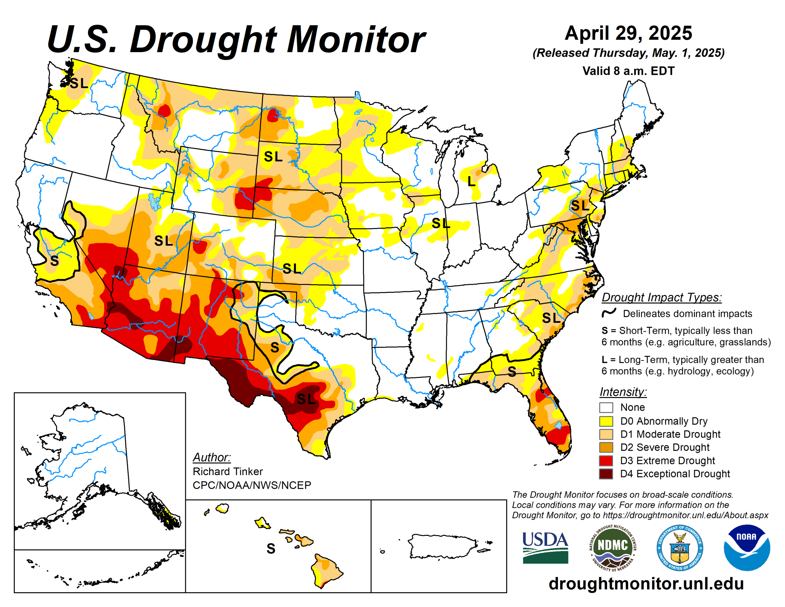
Strong thunderstorms and heavy precipitation again affected parts of the central and eastern contiguous United States, although coverage was spotty in all but a few areas.
Heavy to excessive rains (at least 2 inches) doused portions of the Plains, Mississippi Valley, Upper Southeast, and scattered to isolated sections of the northern and western Great Lakes, Ohio Valley, Carolinas, Northeast, and northern Rockies. In several sizeable areas of the Plains conditions improved significantly.
Meanwhile, rainfall was negligible (several tenths of an inch at best) in most areas from the Rockies westward and in a few areas farther to the east, including much of southern and western Texas, the Oklahoma Panhandle, southeastern Kansas, central and western Nebraska, and central and western North Dakota.
The U.S. Drought Monitor is jointly produced by the National Drought Mitigation Center at the University of Nebraska-Lincoln, the U.S. Department of Agriculture and the National Oceanic Atmospheric Administration. (Map courtesy of NDMC.)
South
The heaviest rain in the contiguous United States fell on a band from central Oklahoma southwestward across the Red River (south) into part of northwestern Texas. An area covering several counties recorded 4 to locally 8 inches of rain.
Lesser but still heavy amounts (over 2 inches) fell on many areas across the rest of northern, central, and eastern Texas, and a few scattered locations across Arkansas. Rainfall during the current and past few weeks led to large areas of improvement across the central, northern, and eastern portions of the Texas dryness and drought coverage, in addition to north-central Oklahoma and the western portions of the state outside the Panhandle.
Dryness and drought remains widespread across most of Texas outside the northeast and over western portions of Oklahoma, with some deterioration to D2 (severe drought) noted in the Oklahoma Panhandle, which missed the week’s heavy rains. A broad area of exceptional drought (D4) remained entrenched across a large swath in central and western Texas.
Arkansas is entirely free of any dryness or drought.
Midwest
Areas of heavy rain covered much of Iowa and Minnesota that continued a wetter-than-normal pattern that has been in place for the last several weeks. Broad areas of widespread improvement were noted through northern Minnesota and a large part of interior Iowa.
Dryness and drought coverage has not been as widespread across northern Missouri. There was very little change to the drought depiction although some small-scale adjustments were made based on recent precipitation observations. In the areas of improvement across northern Minnesota and interior Iowa, precipitation surpluses exist for the last 90 days in sum, although longer-term moisture deficits continue.
High Plains
Precipitation totals varied significantly across this region, but more areas were hit by heavy rains and improving conditions than dryness and deterioration. The dry week led to deterioration across southwestern Kansas, southeastern Colorado, and much of the central tier of Colorado.
Farther north and east, however, widespread heavy rains were noted in several swaths of the Plains and Wyoming, leading to reductions in the intensity and extent of dryness and drought. Improvements were most widespread across central and northwestern Kansas, and most of the state of South Dakota, where heavy rains were most widespread.
Still, despite the improvement in many areas, 60-day precipitation totals were under 25% of normal in southwestern Kansas and southeastern Colorado, with less than half of normal reported in adjacent areas plus parts of central Kansas, central and northeastern Nebraska, and a few other scattered areas.
West
A band of moderate to heavy precipitation (1 to 3 inches) fell across southeastern and south-central Montana. The rest of the West Region was dry this past week, outside a narrow corridor of heavy rain in east-central New Mexico. In addition, some limited improvement was brought into small parts of northern Montana, based on a re-assessment of conditions.
Most observed changes, however, were for the worse. Conditions were broadly downgraded across interior northern Montana, and increasing moisture deficits led to the expansion of D0 (abnormal dryness). In addition, surface moisture depletion has become increasingly obvious across several areas in New Mexico, leading to a significant increase in D3 (extreme drought) coverage there.
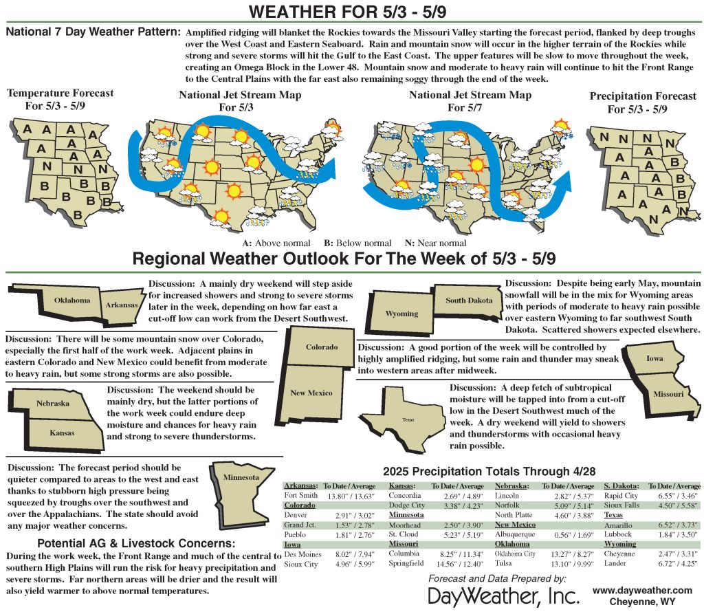
Looking ahead
During May 1 to 5, heavy rain (2 to locally 5 inches) is forecast for central and northeastern Texas and southern Arkansas. Several tenths to an inch are forecast from the central and southern Plains westward through much of the Rockies. Warmer than normal weather is expected from the western Great Lakes through the northern Rockies and Intermountain West, with daily highs averaging 10 to 13 degrees Fahrenheit above normal in the northern Plains and adjacent areas.
Meanwhile, cooler than normal conditions are anticipated from the southern Rockies and central and western Texas. Highs are expected to average 8 to 10 degrees below normal from western Texas through portions of the Great Basin and central through southern California.
The Climate Prediction Center’s six- to 10-day outlook valid May 6 to 10, favors enhanced chances for wetter than normal conditions over the central and southern Plains and Rockies, most of the Great Basin, and the Southwest.
Higher than normal temperatures are favored across roughly the northern two-thirds of the Contiguous United States, with odds exceeding 70 percent in the northern Plains and adjacent Mississippi Valley. Increased odds for subnormal temperatures are forecast for central and western Texas and the central and southern Four Corners region. Chances for significantly cooler than normal conditions exceed 50% across central and southern New Mexico.
Richard Tinker is with the National Oceanic Atmospheric Administration, National Weather Service, Climate Prediction Center, and National Centers for Environmental Prediction.
Related Articles


