Hit-or-miss thunderstorms story of the weather week
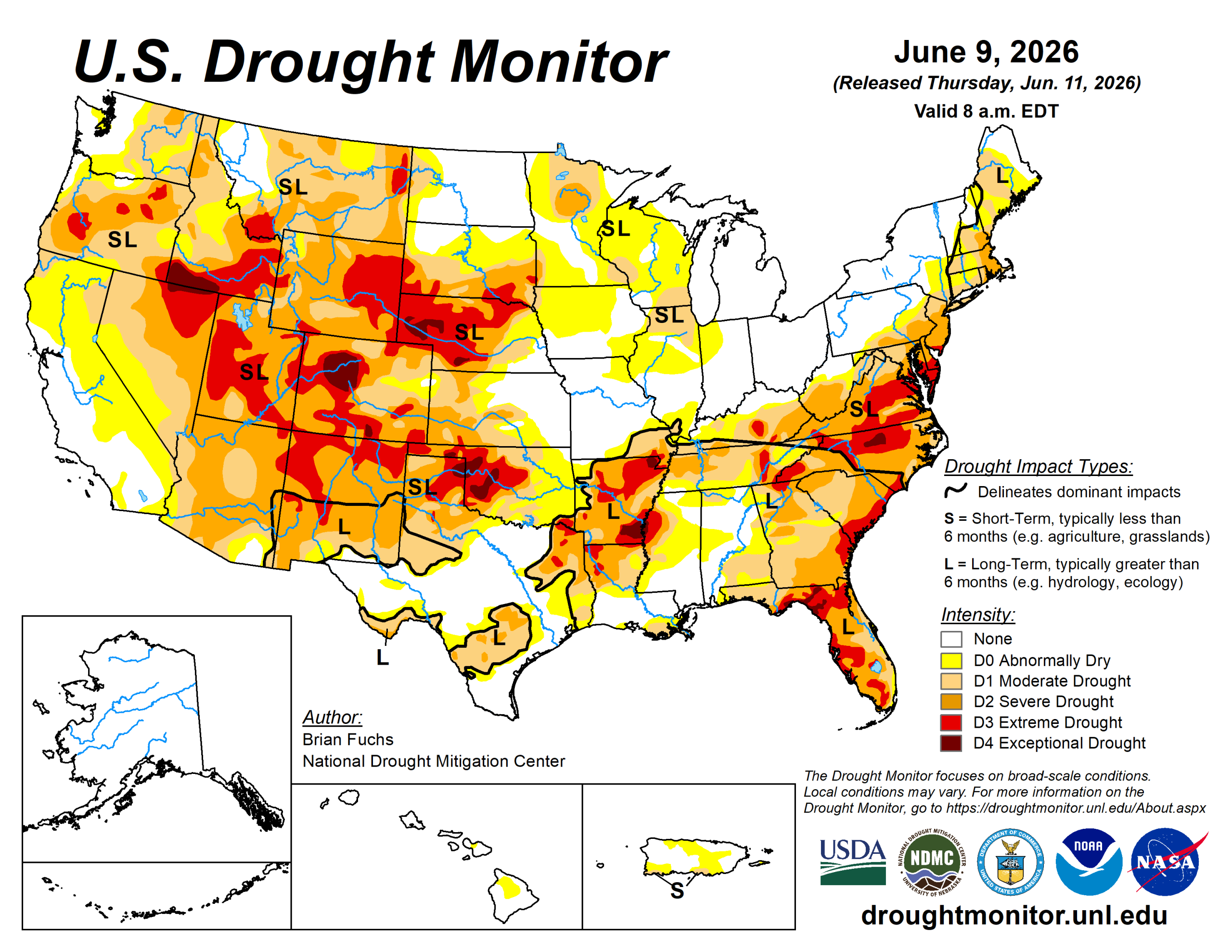
Summer thunderstorms, with their hit-or-miss nature, dominated precipitation patterns across the United States this week.
The greatest departures from normal precipitation occurred across portions of the central and southern Plains, West Texas, New Mexico, and the Midwest.
Portions of west Texas and southeast New Mexico were also below normal. The greatest temperature departures occurred in the central and northern Plains, where portions of Nebraska, South Dakota, North Dakota, and Minnesota experienced temperatures 9 to 12 degrees Fahrenheit above normal.
Drought signals across much of the southern U.S. remain mixed, with wetter short-term conditions developing while long-term deficits persist despite the recent pattern change.
In the Plains, impacts have primarily affected winter wheat and forage production, and areas that have remained dry continue to experience elevated fire danger.
The U.S. Drought Monitor is jointly produced by the National Drought Mitigation Center at the University of Nebraska-Lincoln, the U.S. Department of Agriculture and the National Oceanic Atmospheric Administration. (Map courtesy of NDMC.)
Midwest
Growing short-term drought signals were tempered by a wetter week across much of the region, resulting primarily in improvements, with degradations confined to Minnesota.
The heaviest rainfall occurred from eastern Iowa into western Indiana and across much of western and central Missouri. Below-normal precipitation was common from western Iowa into Minnesota.
Temperatures were mixed, with much of the region above normal and Minnesota averaging 8 to 10 degrees above normal. Near- to below-normal temperatures were observed in southern Missouri.
Improvements to abnormally dry conditions and moderate drought occurred across eastern Iowa and northeastern and southern Missouri.
The most significant change occurred in Minnesota, where the cumulative effects of multiple dry years have affected much of the northern portion of the state, including the headwaters of the Mississippi River. Moderate drought expanded, and severe drought was introduced.
High Plains
Temperatures were generally warmer than normal across the region, with portions of the Dakotas and western Nebraska averaging 9 to 12 degrees above normal. Above-normal precipitation occurred in southern Nebraska, northern Kansas, northern Nebraska into southern and central South Dakota, and across much of northern North Dakota. Areas along the foothills of the Rocky Mountains from Montana through Colorado remained largely dry.
Drought intensity eased where the heaviest rains fell in Nebraska, Kansas and South Dakota, and drought was eliminated in portions of northern Kansas and southeast Nebraska.
Southeast South Dakota continued to miss significant rainfall, and the combination of short- and long-term dryness allowed moderate and severe drought to expand.
Degradation also occurred in eastern Colorado, where extreme drought expanded in the north and moderate drought expanded across east-central portions of the state. Extreme drought was reduced slightly in southern Colorado following recent rainfall.
South
Temperatures were mixed, with Oklahoma and Arkansas averaging 2 to 4 degrees above normal. Meanwhile, much of West, south and east Texas, along with eastern Mississippi and Tennessee, averaged 2 to 4 degrees below normal.
Most of the region received some precipitation, although eastern Arkansas, northern Mississippi, southern Texas, and southwest Oklahoma were the driest locations. The continuing wetter pattern resulted in additional improvements, with drought eliminated across more of central Texas and eastern Oklahoma.
Drought also eased across much of the Texas and Oklahoma panhandles, although widespread severe and extreme drought persisted.
Long-term dryness in far south Texas continues to improve, and improving local conditions combined with short-term data supported the removal of remaining abnormally dry designations. Improvements also occurred in Arkansas where recent wet conditions are beginning to offset longer-term drought indicators.
West
Above-normal precipitation was limited to a few locations, primarily along the Pacific Northwest coast and across southern and eastern New Mexico. Temperatures were above normal across much of the region, with departures of 6 to 9 degrees above normal across western Colorado. Cooler-than-normal temperatures occurred in eastern New Mexico, where departures averaged 3 to 4 degrees below normal.
Although some areas have recently received additional precipitation, a winter characterized by above-normal temperatures and below-normal snowpack continues to affect the region and will likely influence conditions through the summer.
Elsewhere, western Montana benefited from recent rainfall, allowing severe and extreme drought to improve. Southern and eastern New Mexico saw additional improvements following precipitation totals exceeding 200% of normal.
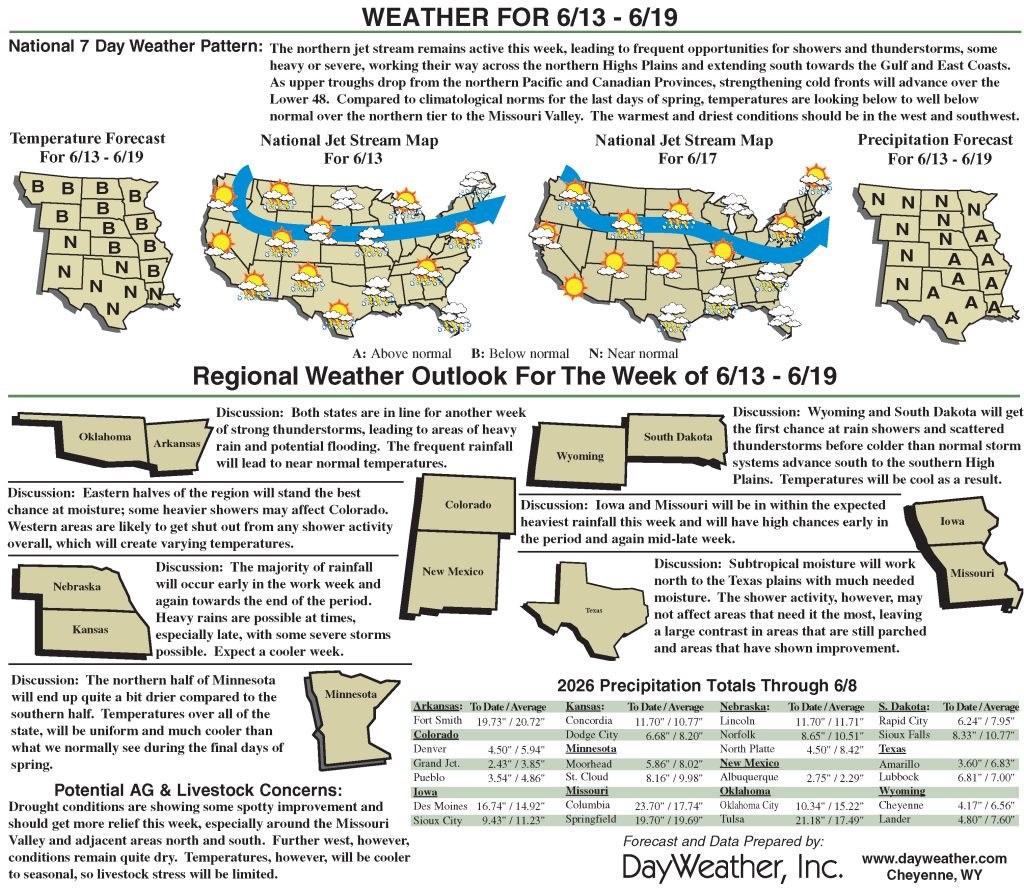
Looking ahead
During the next five to seven days, the West is expected to remain quite dry, while the southern U.S. and portions of the Midwest have the greatest potential for above-normal precipitation. The northern Plains and Southwest are forecast to receive less than an inch of precipitation.
Temperatures are expected to remain warmer than normal across the West. Most of the remainder of the country is expected to experience near- to slightly below-normal temperatures.
The 6– to 10-day outlook shows the best chances for above-normal temperatures will be across the West and Southeast.
Above-normal chances for below-normal precipitation will be over much of the northern Plains and Upper Midwest. Above-normal chances for above-normal precipitation will be mainly in the southern and eastern U.S., with the highest probabilities in South Texas and into the lower Mississippi River Valley.
Brian Fuchs is with National Drought Mitigation Center.
Related Articles


