Be careful what you wish for when it comes to rain
“Rain, rain, go away, come again another day” is a popular children’s nursery rhyme, although it may have a limited shelf life in the High Plains.
My dad used to say, “Dave, we can always work around rain in western Kansas.”
About a week ago in Dodge City, Kansas, we saw how a major storm can change the spirits of many. For those who don’t know, our region was classified in the moderate to severe drought stage by the U.S. Drought Monitor when the map was released Oct. 1 (the data was collected through Sept. 29).
High Plains Journal has a regular online feature about the drought map and summary. Go to hpj.com, click on Crops and scroll to Drought Monitor.
Team effort
The U.S. Drought Monitor has been a team effort since its inception in 1999, produced jointly by the National Drought Mitigation Center at the University of Nebraska-Lincoln, the National Oceanic and Atmospheric Administration and the U.S. Department of Agriculture. Meteorologists and climatologists from the NDMC, NOAA and USDA take turns as the lead author of the map, usually two weeks at a time. The author’s job is to do something that a computer can’t. When the data is pointing in different directions, they make sense out of it.
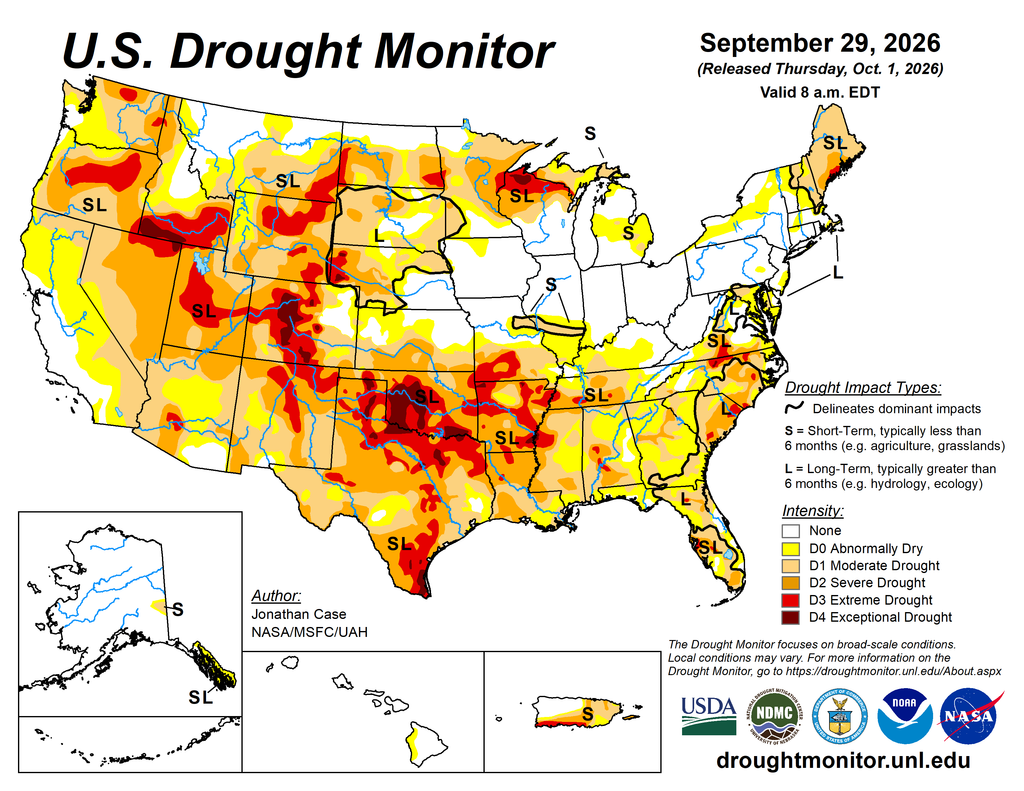
The USDA uses the Drought Monitor to trigger disaster declarations and eligibility for low-interest loans. The Farm Service Agency uses it to help determine eligibility for its Livestock Forage Disaster Program, and the Internal Revenue Service uses it for tax deferral on forced livestock sales due to drought. State, local, tribal and basin-level decision makers use it to trigger drought responses or declare drought emergencies, ideally along with other local indicators of drought. Though these various entities use the USDM, it does not in itself trigger any political actions.
A constant watch
Weather is the No. 1 variable farmers and ranchers face in the High Plains. Favorable weather improves the odds for a better wheat, corn, sorghum or soybean crop. USDA’s National Agricultural Statistics Service each month issues the World Agricultural Supply and Demand Estimates report. When reading WASDE, weather conditions are cited as a reason bushels per acre go up or down. Farmers and grain traders closely watch the report, and we also publish it online.
Ranchers—particularly cow-calf producers—need rangeland and forage to expand their herds. While politicians may think they can put policies in place to increase a record-low U.S. cattle herd, the fact is the regions where cow-calf production has been stymied are the same ones that show up on the Drought Monitor. It takes at least two years from when a calf is born before the animal is ready to be processed.
That is no mystery to cattle producers who live in Kansas, Nebraska, South Dakota, Colorado, Wyoming, Montana, Oklahoma, Missouri and Arkansas. While cattle prices remain at historic highs, ranchers can expand only as much as Mother Nature provides.
At my house in Dodge City, I received more than 5 inches of rain over three days. The rain came down slowly enough that my parched lawn easily absorbed it. What was once brown and dormant greened up and needed mowing several days later.
My hope is that many farmers and ranchers receive beneficial rain this fall to provide optimism for 2027. Wishing for the rain to come back another day may be a wish one regrets because Mother Nature is a fickle beast.
Dave Bergmeier can be reached at 620-227-1822 or [email protected].