Beneficial rain fell on the Northern Plains
The area with the highest rainfall amounts this past week was primarily a wide band from Nebraska east to Iowa, Illinois, Indiana, Ohio, and West Virginia.
Totals exceeding 5 inches were observed in central Illinois and Indiana, with some areas of east Indiana receiving over a foot of rain. These storms were tracking to the east on the north-side of a high pressure over the southern United States.
The northern Great Plains states also received 1 to 3 inches over wide areas, as did southeast Wyoming, eastern Colorado, and northwest Kansas. In the Southwest, monsoonal flow continued with scattered storms, providing rainfall amounts generally between 0.5 and 1.5 inches. The high pressure over the southern U.S. suppressed precipitation over the southern Great Plains and lower Mississippi valley.
Temperatures were particularly above normal in the southern Great Plains and lower Mississippi valley, with the warmest above normal area over Oklahoma. The West as well as the Southeast were also a few degrees above normal.
Rain and storms in the central states from Wyoming to Ohio kept temperatures in this region slightly below average. The northern Great Plains had the coldest below normal temperatures.
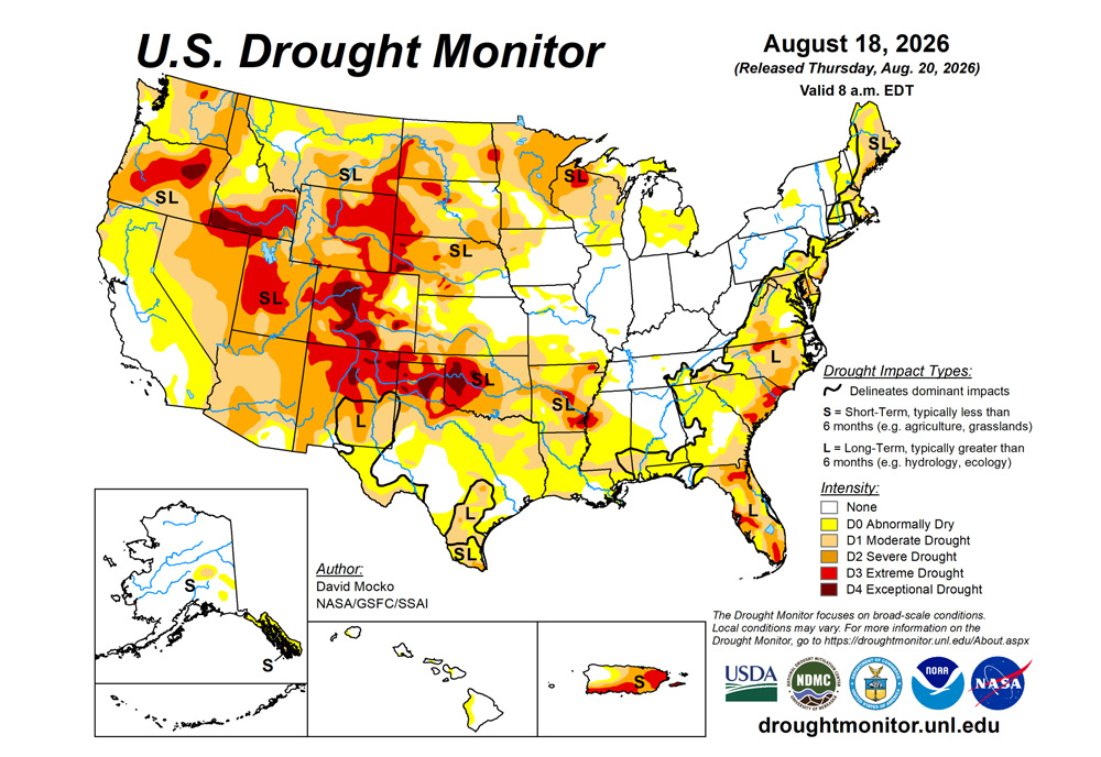
The U.S. Drought Monitor is jointly produced by the National Drought Mitigation Center at the University of Nebraska-Lincoln, the U.S. Department of Agriculture and the National Oceanic Atmospheric Administration. (Map courtesy of NDMC.)
South
Dryness and drought continued over this region for the past week. All states saw declining drought conditions.
The high pressure over the South resulted in anomalously warm temperatures and almost no precipitation. Flash drought conditions had led to dry ponds and creeks and poor to very poor crop conditions in Texas, Arkansas and Oklahoma. Drought also was degraded over much of southern Mississippi.
Extreme to exceptional drought conditions continue in western Oklahoma and the Texas Panhandle, as well as southeastern Arkansas.
Midwest
Widespread and heavy rainfall fell in an area from Iowa, Illinois, Indiana, Ohio, to eastern Kentucky.
The rainfall led to removal of all abnormally dry areas in Indiana, Ohi, and Kentucky as well as most of Illinois. Iowa, Illinois, and northern Missouri had drought improvement. Southern Missouri had degradation from the warm temperatures and lack of rainfall. Minnesota had more scattered rainfall, resulting in small areas of both drought improvement and degradation. There is an area of extreme drought in northern Wisconsin.
High Plains
Southern Kansas had some drought degradations from the flash drought warm and dry conditions over the past week. However, eastern Colorado and Wyoming east through Nebraska and northern Kansas received welcome rainfall resulting in drought improvements in these areas.
South Dakota was mostly status quo from the past week. North Dakota was mostly dry leading to degradation in drought. Two areas in the southwest and northwest of North Dakota received some rainfall and drought improvement.
Extreme drought continues to be in place over western South Dakota and western Nebraska, extending into much of Wyoming and central/western Colorado. Exceptional drought locations are noted in western Nebraska and parts of Colorado.
West
Eastern New Mexico was warm and dry and had areas of drought degradation. Areas near the Idaho/Montana border as well as northeastern Montana received the most rainfall.
Southeastern Montana received little rainfall resulting in a corresponding area of drought degradation.
Looking ahead
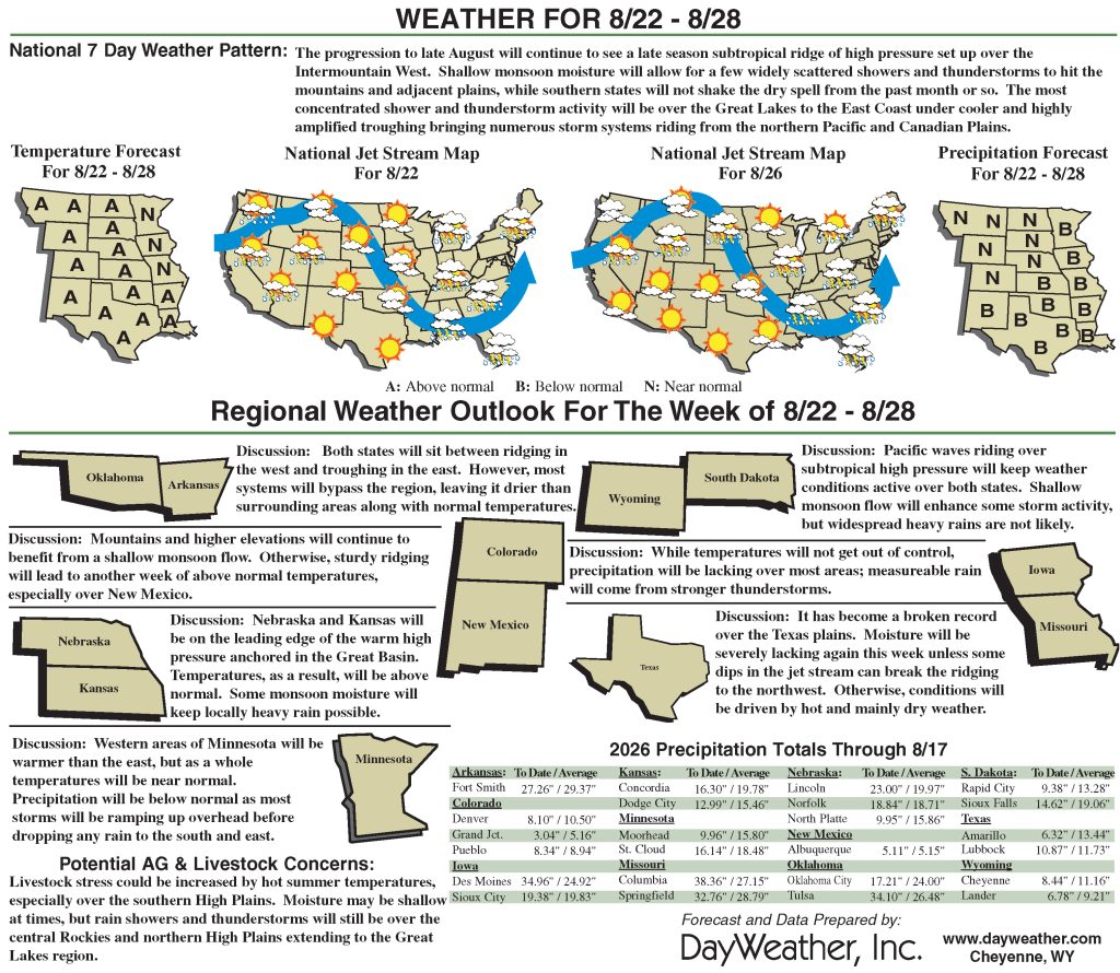
Over the next five days leading up to next Tuesday, northern Minnesota could see beneficial rain. The area where the Ohio River and Mississippi River meet is also forecast to receive above-normal rainfall. The South should continue to have below-normal rainfall, with the Southwestern states having moderate monsoonal rains.
The 6- to 10-day outlook (Aug. 25 to 29) favors above-normal precipitation across the northern half of the Eastern Seaboard from South Caroline to the eastern Great Lakes region and into New England. Below-normal rainfall is favored over much of Texas.
Temperatures are likely to be well above-normal over much of the continental U.S.
David Mocko is with SSAI/NASA/GSFC.