Drought and abnormal dryness intensify in the Plains
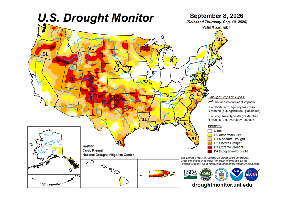
Drought and abnormal dryness continued to expand or intensify this past week across parts of the central and south-central United States as flash drought conditions continued from much of Texas northeast to the middle and lower Mississippi River Valley.
Warmer-than-normal temperatures, ranging from 10 to 15 degrees Fahrenheit above normal in much of the central Great Plains, Corn Belt and Missouri, combined with mostly dry weather in these areas to support worsening drought. Largely drier weather also continued along parts of the North Dakota-South Dakota border, in southeast Montana and in southwest Colorado, leading to degradations occurring in parts of these areas.
In contrast, heavy rains fell from southeast South Dakota into western Iowa and southern Minnesota, in northern North Dakota, and in parts of the northern Rocky Mountains in Montana. Tropical Storm Edouard and its remnants delivered very heavy rain amounts, locally 10 to 15 inches or more, in a narrow corridor in southeast Texas.
The U.S. Drought Monitor is jointly produced by the National Drought Mitigation Center at the University of Nebraska-Lincoln, the U.S. Department of Agriculture and the National Oceanic Atmospheric Administration. (Map courtesy of NDMC.)
South
Large parts of the South region continued to quickly dry amid mostly above-normal temperatures and dry weather. A few exceptions include southern Louisiana, southeast Texas (where former Tropical Storm Edouard dropped rain amounts that locally exceeded 10 inches), and parts of the western Oklahoma Panhandle, where scattered thunderstorm rains occurred.
Isolated one-category improvements occurred in the Oklahoma Panhandle, while one- and two-category improvements occurred in southeast Texas, where precipitation deficits were either reduced or erased entirely, along with improved soil moisture and streamflow. Elsewhere, mostly dry weather and hot temperatures (5 to 15 degrees above normal) covered a wide area from western and northern Texas through most of Oklahoma and Arkansas. Short-term rainfall deficits continued to grow across much of the region, along with dropping soil moisture and streamflow levels, leading to widespread agricultural drought impacts.
Large areas of degrading conditions spread from much of Texas into eastern Oklahoma and Arkansas.
Midwest
Weather and drought (or lack thereof) conditions were a mixed bag across the Midwest this week. Temperatures across the region were warmer than normal, with most of the region finishing the week at least 5 to 10 degrees above normal, and large portions of Iowa, Missouri and Illinois finishing the week 10 to 15 degrees above normal.
Thunderstorms dropped heavy amounts of rain, locally exceeding 5 inches, in northwest Iowa and southern Minnesota. Notable rains of 1 to 2 inches or more also fell in parts of northern (especially northwestern) Minnesota. Elsewhere, with a few exceptions, dry weather came along with the heat, and most of Missouri (excluding the northwest), received little or no rainfall.
Moderate, severe and extreme drought coverage grew across south-central and southwest Missouri, where significant short-term precipitation deficits and soil moisture deficits continued to build amidst declining streamflow in some areas. Widespread agricultural drought impacts were occurring across south-central and southwest Missouri given these conditions and the early-autumn heat wave.
Short-term moderate drought also expanded in northeast Missouri where short-term rainfall deficits grew and soil moisture and streamflow dropped. While not yet at drought levels, abnormal dryness expanded across much of Missouri, southern Illinois and western Kentucky, where conditions have quickly dried due to the hot and dry weather pattern of the past few weeks.
Heavy rains led to improving conditions in west-central and northwest Iowa (and adjacent southwest Minnesota), and northwest Minnesota. Extreme drought expanded slightly into the Twin Cities area, where short- and mid-term precipitation deficits increased.
High Plains
Conditions in the High Plains region ] were mixed. Scattered heavy rains fell in northeast and southwest Nebraska, southeast South Dakota, northern North Dakota and far southwest Kansas, leading to localized or widespread improvements in these and neighboring areas.
However, temperatures across the region were warmer than normal, leading to abnormally high atmospheric thirst and widespread degrading conditions in parts of the region. Temperatures were mostly 10 to 15 degrees above normal in Kansas, eastern Nebraska and southeastern South Dakota.
Eastern Kansas and southeast Nebraska were particularly hot and dry, leading to large expansions of moderate, severe and extreme drought in south-central and southeast Kansas, and the introduction of abnormal dryness in much of northeast Kansas.
Unusually wet weather in August kept conditions in southeast Nebraska from drying as much as areas farther south and southeast. Severe and extreme drought also grew in coverage in southeastern North Dakota, where warm and dry weather this week worsened precipitation deficits and soil moisture conditions.
Drought conditions improved in southeastern South Dakota, and adjacent far northeast Nebraska, where rain amounts of 2 to 5 inches fell. Similar amounts of rain fell in parts of northern North Dakota, leading to improvements in soil moisture and streamflow there and improving drought conditions. Heavy rain amounts of 1 to 3 inches fell in parts of southwest Nebraska and the Nebraska Panhandle, and adjacent northeast Colorado, lessening precipitation deficits and improving drought conditions.
West
Eastern portions of New Mexico and Montana were warmer than normal, with temperatures in most areas 5 to 10 degrees above normal. Widespread moderate to heavy precipitation fell in western and northern Montana. Precipitation amounts in western Montana and northern Idaho ranged from 2 to 6 inches. This led to increased soil moisture and streamflow and lessened short- and long-term precipitation deficits, and the coverage of moderate and severe drought and abnormal dryness lessened in some areas. In southeast Montana, warm and dry weather led to decreased streamflow and soil moisture in a few areas, leading to localized expansion of severe and extreme drought.
Looking ahead
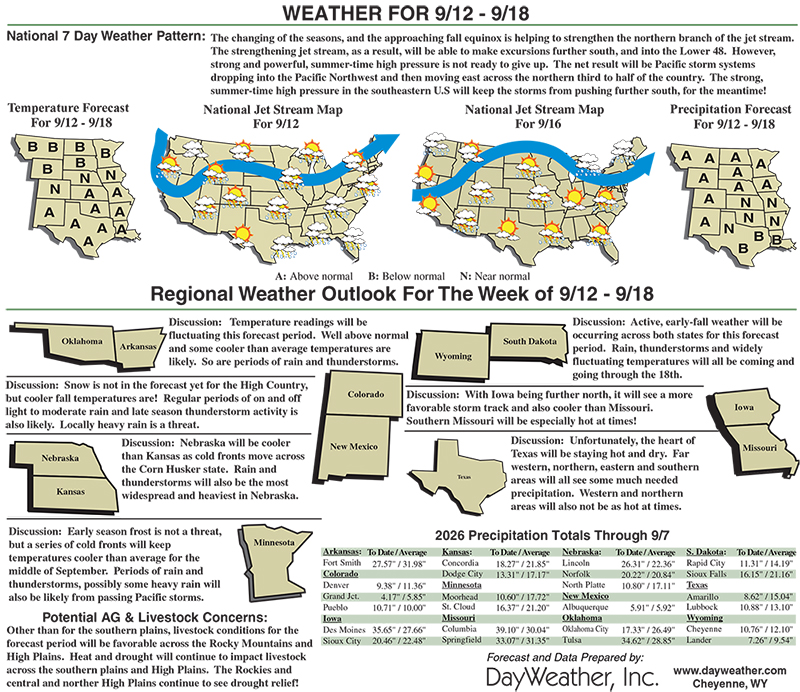
From the evenings of Sept. 9 to 14, the National Weather Service Weather Prediction Center precipitation forecast is for mostly dry weather in the West, and in the western half of the Great Plains, except for parts of north-central Idaho eastward across Montana into North Dakota, where over 0.75 inches of precipitation are forecast in most areas.
Eastern parts of South Dakota, Nebraska, Kansas, and Oklahoma may also receive 0.75 inches or more of rain, with some parts of eastern Kansas and western Missouri forecast to receive 1.5 inches of rain or more. Much of northern Iowa and Minnesota are forecast to receive at least 1.5 inches of rain.
Generally drier weather, with local exceptions, is forecast in Texas.
For Sept. 15 to 19, the National Weather Service Climate Prediction Center forecast favors above-normal precipitation for much of the contiguous United States, especially in the Four Corners states. Warmer-than-normal temperatures are favored across much of the southern U.S.
Cooler-than-normal temperatures are favored in North Dakota, northern South Dakota, northwest Minnesota and most of Montana.
Curtis Riganti is with National Drought Mitigation Center.