Heavy precipitation fell across large portions of the central United States, as a series of storm systems caused continued bouts of severe thunderstorms and unfortunately included more significant tornadoes.
The wet weather across portions of the Great Plains and Midwest led to either scattered or widespread improvements to ongoing drought or abnormal dryness. Dependent on precipitation amounts, improvements to soil moisture and streamflow were noted. The degree of long-term dryness remaining in different locations.
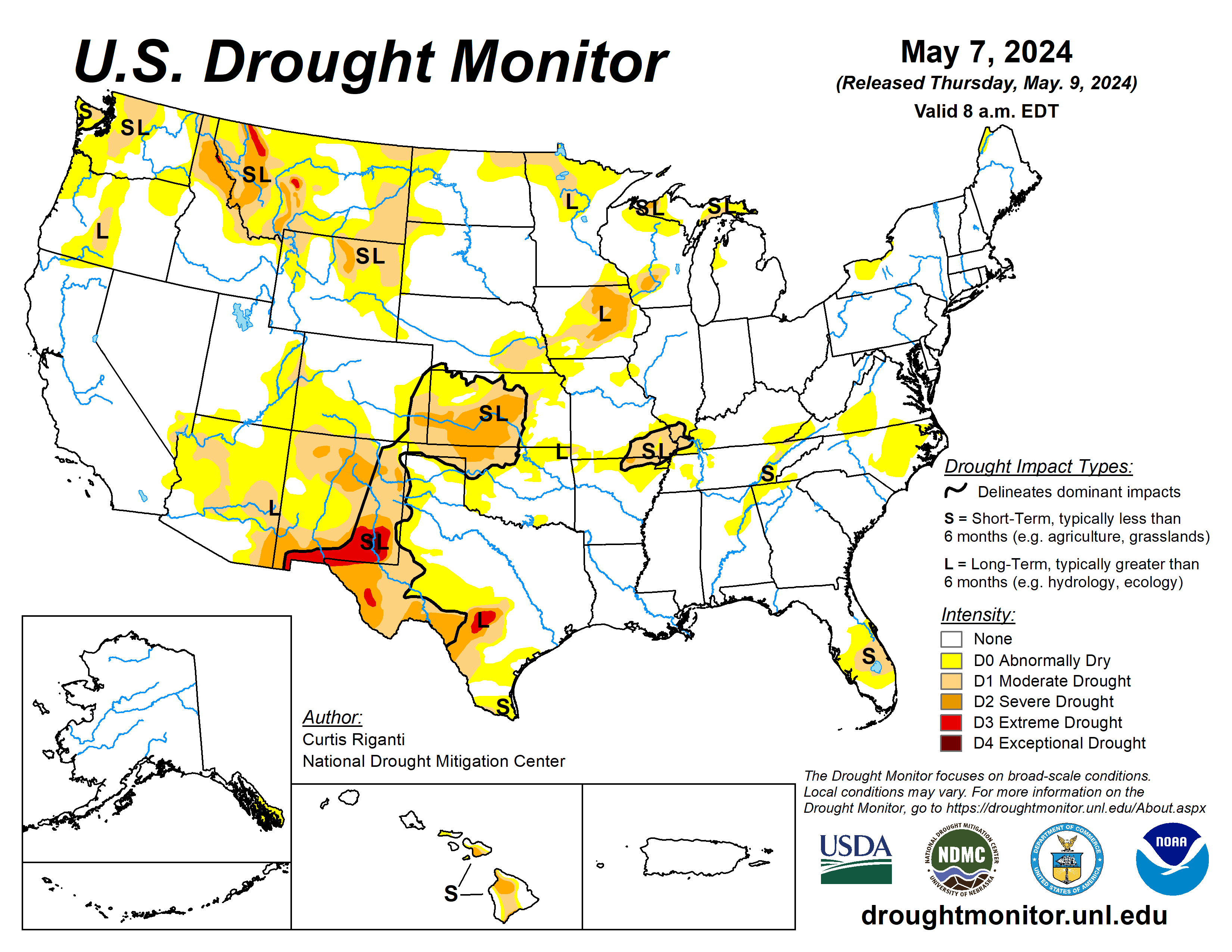
In southwest Kansas and adjacent eastern Colorado, mostly to the west of where this week’s showers and thunderstorms occurred, flash drought conditions continued and severe and moderate drought expanded in coverage.
The U.S. Drought Monitor is jointly produced by the National Drought Mitigation Center at the University of Nebraska-Lincoln, the U.S. Department of Agriculture and the National Oceanic Atmospheric Administration. (Map courtesy of NDMC.)
South
Widespread heavy rains fell across portions of the South region, especially in western Arkansas, central and eastern Oklahoma, and central and eastern Texas.
In areas of improvements to drought and abnormal dryness in central and eastern Oklahoma and Arkansas, recent showers and thunderstorms continued to improve precipitation deficits, streamflow and soil moisture. In central Texas, a tight gradient in long-term drought conditions has developed, as heavier rains have recently fallen along the northern edge of moderate to extreme long-term drought conditions.
Some reservoirs have seen some recent improvement in levels in the area, though significant deficits remain. In deep south Texas, dry weather over the last month or two has led to significant short-term precipitation deficits, and a small area of short-term moderate drought developed.
Midwest
Widespread heavy rain fell across Iowa, Missouri and southern Minnesota. In the western half of the Midwest region, widespread improvements to drought occurred as the recent wet pattern continued, alleviating short-term precipitation deficits in most areas and creating short-term surpluses in some.
Streamflows and near-surface soil moisture improved as a result in many areas, leading to some improvements to drought conditions. However, significant long-term precipitation and groundwater deficits remain in many areas, especially in parts of Iowa. The current drought depiction still shows widespread moderate and severe long-term drought there.
High Plains
Moderate to heavy rain amounts fell in eastern portions of the High Plains region, especially in central and eastern Nebraska, northern and eastern Kansas and eastern North Dakota. Temperature anomalies varied across the region, with temperatures coming in 3 to 6 degrees Fahrenheit above normal in southern Kansas, while northwest Colorado and Wyoming finished the week at 3 to 9 degrees colder than normal.
In eastern Kansas and Nebraska and in eastern North Dakota, heavy rains continued the recent wet pattern, leading to improvements in ongoing drought and abnormal dryness. In parts of eastern Nebraska, improvements were somewhat tempered by remaining long-term precipitation deficits and hydrologic impacts from those deficits.
In southwest Kansas and adjacent southeast Colorado, many areas mostly or completely missed out on recent rains, continuing the very dry weather from the last few months, during which Dodge City tied its record for the driest April on record there (with just 0.02 inches of precipitation).
In these areas, flash drought conditions continued, and severe and moderate short-term drought expanded. Given the time of year during which this drought began, severe impacts to the wheat crop in portions of Kansas have occurred. Recent dryness led to some expansion of drought and abnormal dryness in portions of eastern Wyoming as well.
West
The West region this week saw heavy precipitation (locally exceeding 2 inches) fall in eastern Montana. The heavy rains in eastern Montana ended a recent stretch of dry weather there, preventing any degradation to ongoing drought.
The effects of these rains across the eastern plains will be evaluated further next week. Except for eastern New Mexico and parts of Arizona, most of the West region was colder than normal this week.
Looking ahead
As of time of writing (the afternoon of May 8), precipitation forecasts from the National Weather Service Weather Prediction Center show mostly dry weather west of the Continental Divide within the contiguous U.S. through the evening of May 13.
East of the Continental Divide, 0.5 to 1 inch of rain, with locally higher amounts, is forecast for portions of central and eastern Colorado, western Kansas, the Texas and Oklahoma panhandles, western Oklahoma and northeast New Mexico.
Heavier rain amounts (locally exceeding 2 inches) are forecast from eastern Texas eastward across Louisiana. Separate areas of forecasted rainfall above an inch are in north-central Iowa.
For May 14 to 18, the National Weather Service Climate Prediction Center forecast favors warmer-than-normal temperatures across most of the contiguous U.S., with the exceptions of portions of the south-central U.S. from Oklahoma to Tennessee. Precipitation forecasts in the contiguous U.S. favor near- or above-normal precipitation across most areas, except for the Pacific Northwest and a small part of southwest Texas.
Curtis Riganti is with the National Drought Mitigation Center.
Related Articles


