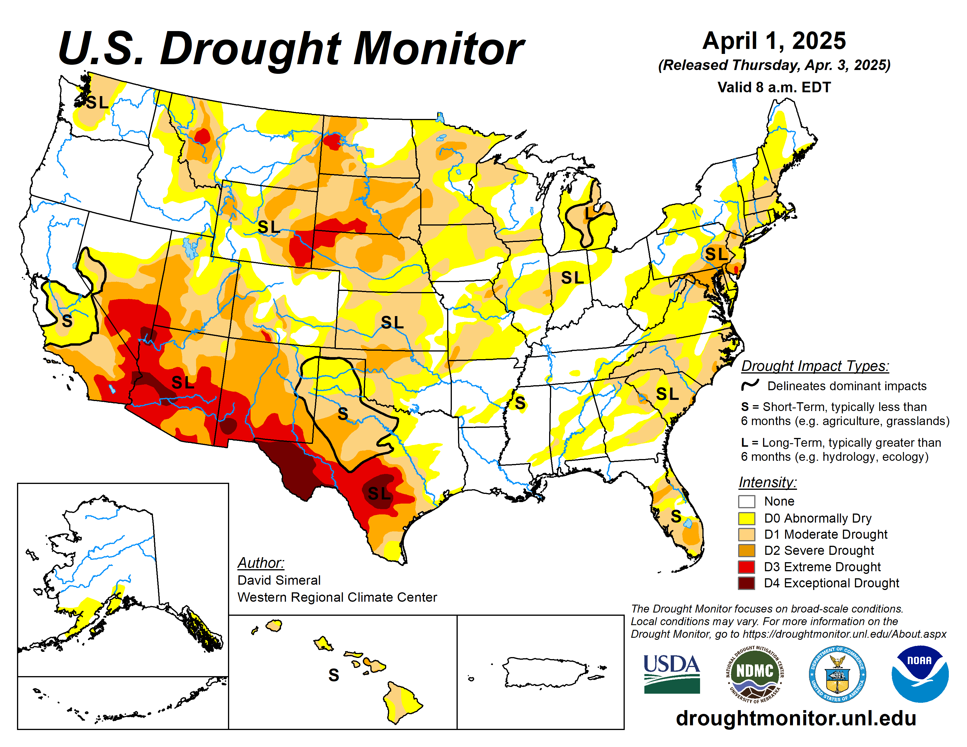
The latest U.S. Drought Monitor saw improvement in drought-related conditions across areas of the Intermountain West, High Plains, South, Upper Midwest, and Southeast.
Meanwhile, conditions degraded on the map in the Southwest, Lower Midwest, and the Mid-Atlantic. Out West, a series of Pacific storms delivered significant rainfall to the lower elevation coastal areas and heavy mountain snow in the Klamath Mountains, Cascades, and Sierra Nevada ranges, as well as to the higher elevations of the Great Basin and the central and northern Rocky Mountains.
In the Southwest, drought expanded and intensified across areas of southeastern and northeastern Arizona, northeastern New Mexico, and southwestern Colorado, where snowpack levels are below normal in the San Juan and Sangre de Cristo ranges.
In the South, southern Texas received record-breaking rainfall (12+ inches) leading to widespread improvements in drought-related conditions. In the Pacific Northwest, Hungry Horse Reservoir in northwestern Montana is 72% full (108% of average).
The U.S. Drought Monitor is jointly produced by the National Drought Mitigation Center at the University of Nebraska-Lincoln, the U.S. Department of Agriculture and the National Oceanic Atmospheric Administration. (Map courtesy of NDMC.)
South
Generally dry conditions prevailed across areas of the region including Oklahoma, western Texas, Arkansas, and southern Mississippi. Conversely, the Gulf Coast regions of Texas and Louisiana received very heavy rainfall in some areas (5 to 15 inches based on radar estimates), with the highest accumulations observed along the southern Gulf Coast region of Texas and the south Texas Plains. The deluge of rainfall led to life-threatening flooding and loss of lives. The rains also led to significant improvements in drought-related conditions, with multiple category improvements made on the map.
In contrast, short-term dry conditions continued in Arkansas, although heavy rains are expected to impact the state over the next week. For the week, average temperatures were well above normal, with anomalies ranging from 4 to 10+ degrees Fahrenheit. Looking at reservoir conditions in Texas, statewide reservoirs are reported to be 75.3% full, with many reservoirs in the eastern part of the state in good condition, while numerous reservoirs in the western portion of the state continue to experience below-normal levels, according to Water for Texas (April 2).
Midwest
A seven-day precipitation ranged from 1 to 2 inch accumulations in some areas, while northern Minnesota and eastern Iowa were generally dry.
According to NWS NOHRSC, the Northern Great Lakes region is currently 44.4% snow covered, with an average depth of 3.5 inches and a maximum depth of 58.6 inches.
High Plains
On this week’s map, only minor changes were made in the region, namely in western Nebraska and areas of Kansas. In the Sand Hills of Nebraska, precipitation during the past seven-day period (1 to 2 inches) led to 1-category improvements in areas of severe and extreme drought.
In Kansas, short-term dry conditions (past 30-60 days) led to the expansion of isolated areas of drought in the southwestern and northeastern parts of the state. Generally dry conditions prevailed across much of the region for the week, with some small accumulations (0.5 to 1 inch liquid) observed in southern and eastern South Dakota, northern Nebraska, and southeastern Kansas. In terms of temperatures, near-normal average temperatures were logged across the region.
West
In the Desert Southwest, areas of extreme drought expanded in northeastern and southeastern Arizona in response to very low streamflows and below-normal precipitation since the beginning of the water year (Oct 1).
In areas of southwestern and south-central Colorado, degradations were made on the map where snowpack conditions at numerous NRCS SNOTEL stations are reporting well below-normal SWE levels. Likewise, poor snowpack conditions have been observed in the mountain ranges of southern Utah, northern Arizona, and northern New Mexico.
Looking ahead
The National Weather Service’s Weather Prediction Center 7-Day Quantitative Precipitation Forecast calls for moderate-to-heavy precipitation accumulations ranging from 3 to 10+ inches (liquid) across areas of the South, Lower Midwest, and the Pacific Northwest (Washington), with the heaviest accumulations expected in the Middle Mississippi Valley and Ohio River Valley regions.
Light-to-moderate accumulations are expected in areas of the Southeast, Mid-Atlantic, Upper Midwest, and central and Southern Plains. In the central and southern Rocky Mountains, mountain snowfall is expected.
The Climate Prediction Center’s 6-10-day Outlook calls for a moderate-to-high probability of above-normal temperatures across the western U.S. and Plains, while below-normal temperatures are expected across the Midwest. In terms of precipitation, there is a moderate-to-high probability of below-normal precipitation across most of the West, Plains, South, and the Midwest.
Elsewhere, above-normal precipitation is expected across the Eastern Seaboard and in the Pacific Northwest (Washington).
David Simmeral is with the Western Regional Climate Center.
Related Articles


