Welcome rains fell in parts of the Plains
Precipitation fell across much of the United States this past week, with heavier amounts (more than 1 inch) falling from portions of the central and southern Plains eastward to the East Coast, and also in parts of the West.
Much of the southeastern U.S., from eastern Texas to North Carolina, reported weekly rainfall totals between 2 to 10 inches, while similar amounts (2 to 6 inches) were reported in parts of the Northeast. Above-normal precipitation supported drought improvements across large portions of the South, Southeast and Northeast, and in parts of the Southwest and High Plains.
Conversely, weekly precipitation totals were below normal across much of the West to the Midwest. Drought and abnormal dryness were expanded or intensified in northern portions of the West and Midwest, as well as parts of the Southwest and High Plains. Temperatures were above normal across much of the U.S., with areas of the north-central U.S., from central Montana to Minnesota, reported temperatures 9 to 20 degrees Fahrenheit above normal. Below-normal temperatures were observed from the Southern Plains to parts of the eastern Midwest, where departures were up to 10 degrees below normal, with the largest departures being reported in parts of Texas.
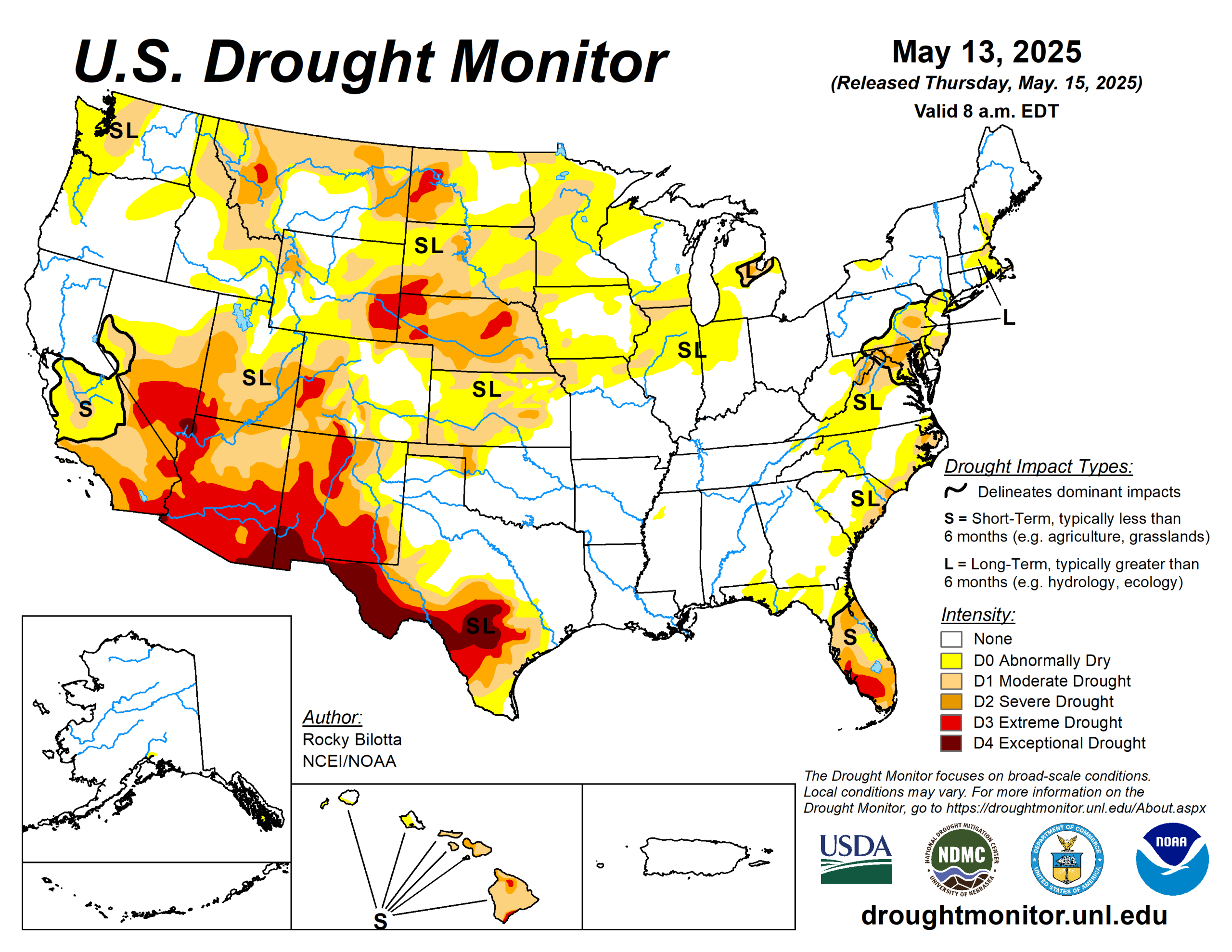
The U.S. Drought Monitor is jointly produced by the National Drought Mitigation Center at the University of Nebraska-Lincoln, the U.S. Department of Agriculture and the National Oceanic Atmospheric Administration. (Map courtesy of NDMC.)
South
Cooler temperatures dominated the South, with departures ranging up to 9 degrees below normal. However, small areas of Texas and Oklahoma observed temperatures slightly above normal, with temperatures between 1 to 3 degrees above normal.
Precipitation varied across the region, with heavier amounts (1 to 8 inches) falling in parts of Oklahoma, Texa, and southern Arkansas. Moderate to exceptional drought (D1-D4) was improved in parts of western, central, and southern Texas, while moderate to severe drought (D1-D2) was improved in western Oklahoma. Improvements to abnormal dryness (D0) were made in Oklahoma and Texas. Drought reduction and improvements were based on precipitation totals, short-term SPI/SPEI, NDMC short-term blends, and improvements to streamflow and soil moisture data.
Midwest
Above-normal temperatures, with departures ranging between 1 to 20 degrees above normal, were observed across most of the Midwest, with the largest temperature departures being observed in northern Minnesota.
In contrast, temperatures were below normal across parts of. Precipitation was reported across the southern and eastern portions of the region, with the greatest amounts falling in areas free of drought and abnormal dryness. However, precipitation was below normal across much of the region, with rainfall totals between 50% or less over the past 30 days.
Growing precipitation deficits and degrading conditions, shown in short-term indicators, streamflow, and soil moisture, resulted in the expansion of moderate drought (D1) and abnormal dryness (D0) in central Minnesota, in southern portions of and Iowa, as well as northern portions of Missouri.
High Plains
Warm temperature dominated the High Plains, with departures ranging up to 20 degrees above normal, especially along the northern portions of the region, while cooler-than-normal temperatures were observed along the southern border. Precipitation fell across the western and southern portions of the region; however, in most areas, amounts were insufficient for significant improvement.
Beneficial heavy precipitation (1 to 3 inches) in eastern Colorado and Kansas led to improvements in moderate to severe drought (D1-D2) and abnormal dryness (D0) in these areas. Conversely, dry conditions resulted in the introduction and expansion of drought. Extreme drought (D3) was introduced in western Nebraska, and moderate to extreme drought (D1-D3) expanded in western Colorado and eastern Nebraska. Abnormal dryness was also expanded in southern Wyoming this week.
West
Average temperatures were above normal across nearly the entire region, while below-normal temperatures were observed across much of New Mexico where temperatures were between 1 to 6 degrees F below normal. Conversely, Montana observed temperatures ranging between 3 to 15 degrees above normal. Precipitation varied across the region this week, with beneficial amounts falling in parts of the Southwest and southern Montana.
Moderate drought (D1) was reduced in Montana. Conversely, above-normal temperatures and below-normal precipitation resulted in the expansion of exceptional drought in southern New Mexico, severe drought in Montana, and moderate drought in northern portions of Montana.
Looking ahead
During the next five days (May 13 to 17), the slow moving upper low across the Southeast U.S. will be weakening and evolving into an open trough by Thursday as it exits the East Coast. Another upper trough and closed low across the northern Rockies mid-week will sustain a surface low crossing the Northern Plains and then into south-central Canada by the end of the week, with heavy rain for the Dakotas/Minnesota and late season mountain snow for the northern Rockies.
Going into Thursday, the heavier rainfall reaches eastern North Dakota into northern Minnesota, with some of the guidance indicating the potential for 1- to 2- inch rainfall totals with some embedded convection. Very warm weather will continue across the upper Midwest for the middle of the week, with highs reaching 85 to 90 degrees on Wednesday across the eastern Dakotas and much of Minnesota.
Very hot conditions are expected across southern Texas for the entire forecast period with highs exceeding 100 degrees near the Rio Grande, and HeatRisk reaching the major category for these areas. In contrast, chilly conditions are likely for the Intermountain West and northern Rockies with highs running 5-15 degrees below average with the upper level trough and increased cloud cover.
The Climate Prediction Center’s 6- to 10-day outlook (valid May 18 to 22) favors above-normal precipitation across most of the U.S. Increased probabilities for above-normal temperatures are forecast for the Southern Plains.
Rocky Bilotta is with the National Oceanic Atmospheric Administration and National Centers for Environmental Information.