The National Integrated Drought Information System recently hosted their Summer 2025 Drought and Fire Outlook webinar for the Great Plains June 5.
Eric Hunt of the University of Nebraska Extension discussed current and seasonal conditions as well as gave a climate outlook. Chip Redmond of Kansas State University and the Kansas Mesonet discussed the wildland fire risk and potential.
Conditions
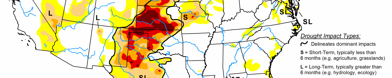
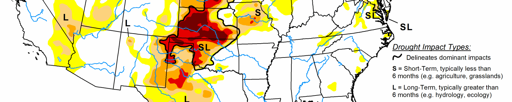
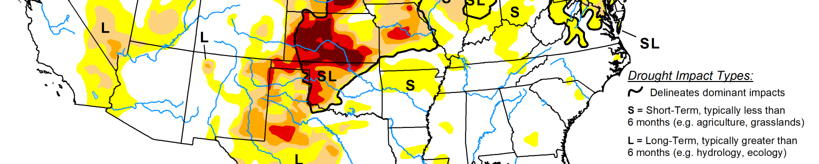
Hunt said in the last three weeks (end of May/first week of June), there’s been improvement across a lot of the High Plains Region.
“From the western Dakotas down through Nebraska into parts of Kansas and Missouri (have had improvement),” he said. “We do have some pockets on the outskirts of seeing some degradation, but the good news is we haven’t seen any widespread degradation in the basin here in the last couple of weeks.”
Nebraska has had a burn ban in place in Nebraska for about a month, Hunt said—from late April through about the first two-thirds of May.
“This was prompted in part because of a major wildfire in Brown County, which is in north-central Nebraska. It was a controlled burn that got out of control thanks to a cold front getting in quicker than I think was anticipated,” he said. “At that point, we were in really bad shape across a lot of the state and across all the High Plains region.”
Looking back 60 days from June 5, Hunt said the most precipitation was in the southeast corner of the basin, where it was around 10 inches. There’s been 10-plus inches across portions of the western Dakotas.
“We have had 8 to 10 inches of rain across portions of Nebraska, particularly north-central Nebraska as well,” Hunt said. “This is very, very badly needed precipitation. We have had a little bit less precipitation than that, certainly as we get toward the north get toward the northwestern side of basin, which be one of the reasons for the degradation the Drought Monitor.”
Hunt expects with recent precipitation, there will likely be a positive impact on soil moisture levels. Conditions pushed rains into areas of the High Plains because of a southerly flow and when it goes to the upper part of the Midwest, it turned northeast.
“We were kind of getting a lot of good wrap-around precipitation,” he said. “That’s one of the reasons that we were able to get some very robust precipitation totals across portions of the Dakotas.”
Hunt explained the evaporative demand drought index, isn’t really a true drought index in any sense of the term, but it compares the potential evapotranspiration compared to historical norms.
“You’ll notice the last three weeks that, because it’s been cooler and some degree cloudier, and with some smoke in there, we really haven’t had a ton of atmospheric demand,” he said. “In the last few weeks has been relatively average, or maybe even a little bit below average. But over the longer term, we have had a relatively prolonged period where we’ve been abnormally warm, we’ve had wind, higher wind speeds, and those are all things that would contribute to higher attention to evapotranspiration.”
Soil moisture levels around the first week of June are still showing pockets of dryness across portions of southeastern Nebraska, eastern South Dakota and eastern North Dakota, according to Hunt.
“(Models are) showing that across most basins, we kind of have near normal soil moisture, maybe even somewhat above normal precipitation or soil moisture across portions of North Dakota,” he said.
Forecast
Hunt said the summer forecast came out in May, and currently conditions are neutral. He expects them to remain that way through the summer.
“There is at least a reasonable chance La Nina will redevelop later on as we get toward the winter,” he said. “There’s also about a one in 10 chance we will be in El Nino by later this year.”
Conditions during early June were “relatively cool,” and Hunt believed they would start changing as the month progressed.
“You’ll probably see more ridging being prominent over the eastern two thirds of counties said it should keep us relatively warm,” he said. “Across most of the basin, there are probably going to be chances of getting some precipitation. So, notice the equal chances of dry and wet. So basically, this means there’s no real strong signal one way or the other, but there will be at least chances getting some precipitation.”
That could mean continued good news for pastures and some crops that need moisture to finish out the season or to get started, Hunt said.
Concerns
Hunt is concerned about the summer mostly because of colder water off the coast of California. Warmer means there is a stronger correlation with a ridge-trough pattern that is “not good for us from a drought perspective,” according to Hunt.
“We had more or less been in the negative phase PDO (Pacific Decadal Oscillation) for the last five years,” he said. “It’s really not the entire blame. It definitely deserves a lot of blame for the amount of drought that we’ve had in the basin and a lot of the western United States last four or five years.”
If you have a negative PDO in late summer and into early fall, there tends to be more ridging over the western U.S., and this tends to be more suppressive of precipitation and warmer temps.
“If you’re not currently in drought, there’s an expectation that you will be in drought by the end of the summer, with maybe a couple of exceptions,” Hunt said.
The rationale behind that is because of the below average precipitation across the basin coupled with warm temperatures.
“So that’s a great recipe for drought,” he said. “I think it will be interesting. I don’t necessarily doubt this statistically. I think there is a very good probability that this will come to fruition.”
According to Hunt, the million-dollar question is if the timely rains come, from an agricultural standpoint, there probably won’t be significant reductions in crop yields.
“And that also may mean that drought may get a little bit worse,” he said. “From a statistical standpoint, they may not have agricultural impacts. Certainly, I think some of the hydrologic impacts would maybe get slightly worse.”
Other models like the European and the CFS model have their own predictions.
Some crops are suffering across the region, and Hunt said the spring wheat in the Dakotas is off to its third worst start on record.
“The winter (wheat) crop in Nebraska is not great,” he said. “Certainly, the southern Panhandle was really struggling because of how dry and warm last fall was. It’s been up until pretty recently, it’s been pretty dry, so the lifespan hasn’t been very good.”
It’s still too early to say how the corn in Nebraska will end up, but the eastern side of the state is looking “really good.”
“We think you actually could use a little bit of warmer weather,” he said. “The good news is the crops around here have a shot at being pretty good, but we really don’t have a lot of margin for error because we just did not get enough precipitation earlier this spring to have a really full profile of moisture.”
Kylene Scott can be reached at 620-227-1804 or [email protected].
Related Articles