Above-normal temps continuing their trend
Much of the country continued to experience above-normal temperatures in April.
During the past week, the warmest temperatures were over the southern Midwest and into the central Plains, where departures were 9 degrees Fahrenheit or greater. California and portions of the Southeast into the Mid-Atlantic were near normal to slightly below normal.
Dryness has continued in the Southeast, portions of the South, the Northeast, and much of the High Plains. The greatest precipitation occurred in the Great Basin, northern California, central and west Texas, northeast Kansas, and across much of Michigan and Wisconsin, where spring thunderstorms developed within an active weather pattern, mainly over the Midwest.
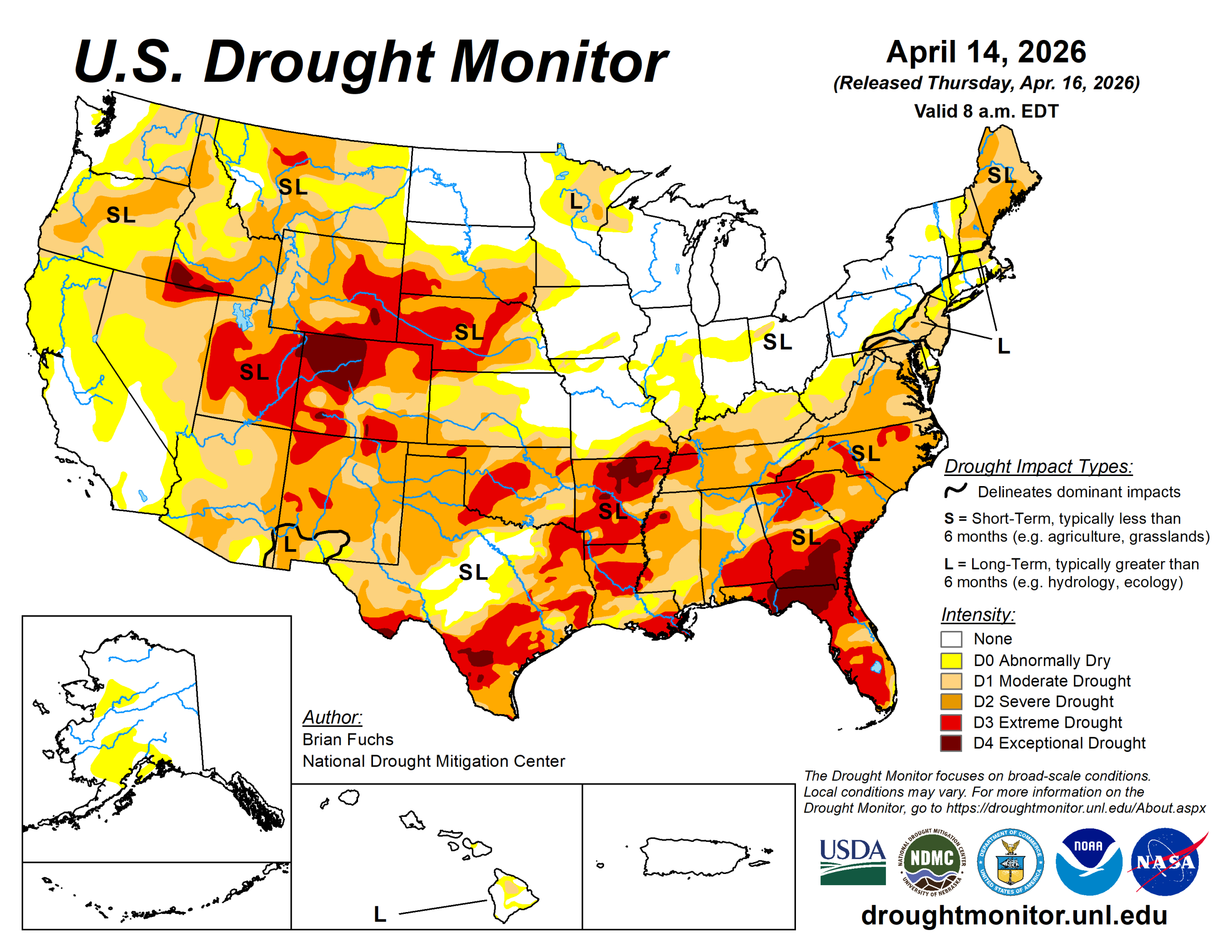
The U.S. Drought Monitor is jointly produced by the National Drought Mitigation Center at the University of Nebraska-Lincoln, the U.S. Department of Agriculture and the National Oceanic Atmospheric Administration. (Map courtesy of NDMC.)
Midwest
An active weather pattern brought significant rainfall to many areas, while locations outside the storm track remained mostly dry.
Areas from western Missouri into southern Iowa, Wisconsin, northern Illinois, and northern Michigan recorded 200 to 400% of normal precipitation for the week. In contrast, areas from southeast Missouri to central Illinois and into Ohio and Kentucky received less than 25% of normal precipitation. Northern Iowa and northern Minnesota were also drier than normal.
Temperatures were above normal across most of the region, with only northern Michigan and Minnesota near or slightly below normal. Parts of Illinois, Missouri and western Indiana were 9 to 12 degrees above normal. Moderate drought expanded across much of eastern and northern Kentucky, while extreme drought expanded over the “bootheel” of Missouri and into far western Kentucky.
In northern Missouri, eastern Illinois, and southern and western Iowa, abnormally dry and moderate drought conditions improved as supported by short-term indicators.
High Plains
Temperatures were mostly above normal, with only eastern North Dakota and northeast South Dakota near or below normal. The greatest departures occurred in central Kansas, where temperatures were 12 to 15 degrees above normal.
Above-normal precipitation was observed in southwest and northern North Dakota.
Kansas experienced the most active weather, with southwest and eastern areas of the state and southeast Nebraska recording above-normal precipitation. Some areas of northeast Kansas received more than 400% of normal precipitation.
These rains led to improvements in abnormally dry and moderate drought conditions across southeast Nebraska and northeast Kansas. Some areas of eastern Nebraska and south-central Kansas also saw improvements.
Extreme drought expanded across southwest Nebraska and northwest Kansas, while severe drought expanded across southwest Kansas. The plains of eastern Colorado experienced nearly a full-category degradation, with expansion of moderate, severe, and extreme drought.
South
Precipitation was mixed across the region. Oklahoma and much of central and western Texas received more than 150% of normal precipitation. Farther east, eastern Arkansas saw light precipitation, while areas farther west remained mostly dry.
Temperatures were above normal across much of the region, with only southern Texas near or below normal. The greatest departures occurred in western Oklahoma and the Texas Panhandle, where temperatures were 12 to 15 degrees above normal.
Extreme drought expanding in the northwest. Arkansas remained dry, with extreme and exceptional drought expanding in both northern and southern areas.
Oklahoma remained largely unchanged, with only minor expansion of severe drought in the panhandle.
The most significant improvements occurred in Texas, where much of central, southern and southeastern portions of the state saw a full-category improvement in drought conditions. However, severe drought expanded in parts of the panhandle.
West
Warmer-than-normal temperatures dominated the region. Departures were 6 to 8 degrees above normal across most of Colorado and Wyoming.
Precipitation was mixed, with parts of eastern and western New Mexico receiving above-normal precipitation.
The lack of snowpack will continue to impact the region in the coming months. Earlier-than-normal snowmelt, below-normal seasonal totals, and increased liquid precipitation are contributing to hydrological impacts.
Severe drought expanded across eastern and northern New Mexico.
Looking ahead
Over the next five to seven days, precipitation is expected to be most prominent across the southern Plains, Midwest and Northeast. The heaviest precipitation is likely from eastern Kansas into Missouri and northward into eastern Iowa, northern Illinois, and the Great Lakes.
Additional precipitation is expected from the Pacific Northwest into the northern Rockies and High Plains. Dryness is likely to persist across much of the Southwest and Southeast.
Temperatures are expected to be above normal from the northern Rockies into the High Plains, with the greatest departures in western Nebraska, eastern Colorado, and central Montana (10 to 13 degrees above normal). Cooler-than-normal temperatures are anticipated across much of central Texas (5 to 9 degrees below normal), while warmer-than-normal conditions are expected across the Mid-Atlantic (5–7 degrees above normal).
The 6- to 10-day outlooks show that the locations with the best chances of experiencing below-normal temperatures are in the Southwest, especially those locations in Arizona and southern Nevada and California as well as in New England with the best chances in both Arizona and Maine.
There is a high likelihood of above-normal temperatures over much of the Midwest, Plains, and into the South and Southeast with the best chances over Kansas, Missouri, Arkansas, Oklahoma into southern Nebraska and Iowa. Precipitation chances are expected to be near-normal over southern Florida and southern areas of New Mexico and Arizona.
Near-normal precipitation is also expected over the Pacific Northwest, upper Midwest and into the Northern Plains. In the Northeast, there will be a mix of near-normal to below-normal precipitation chances.
Most of the rest of the country has above-normal chances of recording above-normal precipitation with the greatest chances over an area from northern Louisiana to Indiana.
Bryan Fuchs is with the National Drought Mitigation Center.
Related Articles


