Continued drought degradation noted in much of the High Plains
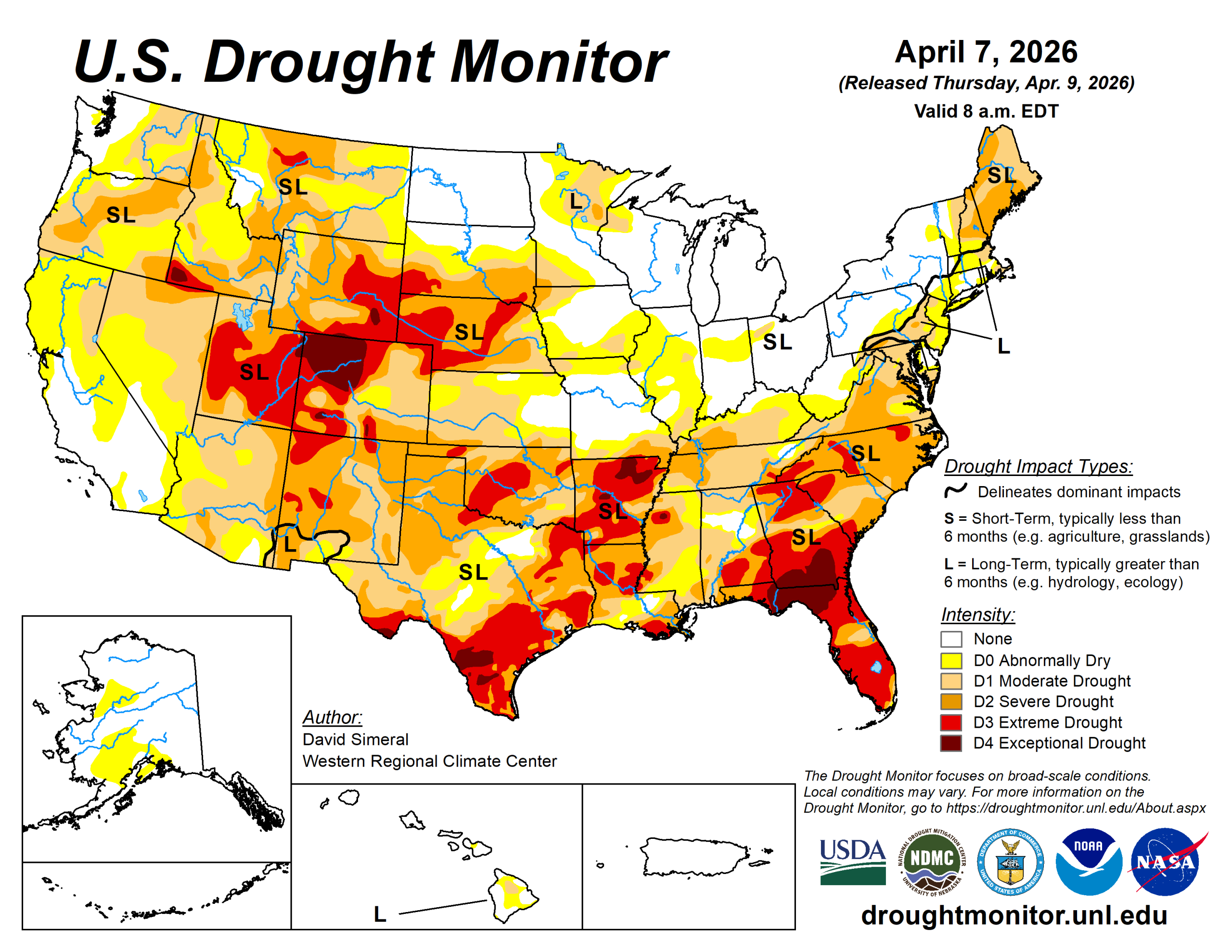
This U.S. Drought Monitor week saw degradations across the areas of the West, Southeast, and Mid-Atlantic, while rainfall during the past week led to improvements in drought-affected areas of the South, Plains, and Midwest.
In the Midwest, widespread improvements were made after another round of precipitation during the past week leading to removal of areas of drought on the map in Iowa, Missouri, Illinois, Indiana, and Ohio.
In these areas, precipitation totals ranged from 2 to 5 inches. Similarly, significant rainfall was observed in portions of Texas, Oklahoma, and Louisiana leading to targeted improvements. Despite the much-needed precipitation, conditions deteriorated on the map in Wyoming, Montana and New Mexico.
According to the latest U.S. temperature and precipitation analysis by National Oceanic Atmospheric Administration’s Center for Environmental Information, March 2026 was the warmest March on record for the contiguous U.S. with average temperatures reaching 9.4 degrees Fahrenheit above the 20th-century average. For the month, 1,432 counties observed their single warmest March day on record (1950-present). Moreover, the April 2025 to March 2026 period was the warmest 12-month span recorded for CONUS since 1895. In terms of precipitation, the January to March period was the driest on record for CONUS, breaking the previous record set in 1910.
Coming into April, mountain snowpack conditions remain well below normal despite this week’s precipitation across the higher elevations of the Cascades, Sierra, and Rockies.
The U.S. Drought Monitor is jointly produced by the National Drought Mitigation Center at the University of Nebraska-Lincoln, the U.S. Department of Agriculture and the National Oceanic Atmospheric Administration. (Map courtesy of NDMC.)
South
Improvements were made in drought-affected areas of Texas, Oklahoma and Arkansas. In terms of precipitation during the past week, moderate to heavy rainfall accumulations (ranging from 3 to 6 inches) were observed in Texas and Oklahoma.
In Arkansas, some beneficial rains fell in the far-western portion of the state, which led to a boost in streamflow conditions. However, dry soils and significant precipitation deficits remain across the state with the NDMC CMOR tool showing many new impact reports during the past week. Looking at climatological rankings for the past 60-day period (Feb. 7 to April 7), record to near-record dryness was observed in the region, including in Del Rio, Texas (driest on record; -1.98 inches) and Monticello, Arkansas (fourth driest; -5.7 inches.
In Texas, Water for Texas (April 7) reports statewide reservoirs at 74% full, with eastern reservoirs in good condition while many western and southern reservoirs remain below normal. Average temperatures for the week were above normal across the region (2 to 12 degrees).
Midwest
Widespread improvements were made across Minnesota, Iowa and Missouri in response to the cumulative impacts of precipitation events during the past 30-day period.
Noteworthy, some multiple-category improvements were made in northern portions of Illinois, Indiana and Ohio where the heaviest precipitation totals (ranging 2 to 5 inches) were observed during the past week.
In Kentucky, short-term dryness and developing hydrologic drought conditions led to expansion and intensification of drought. Temperatures were above normal across most of the region, with anomalies ranging from 2 to 15 degrees.
High Plains
Rainfall (1 to 4 inches) led to targeted improvements in far eastern portions of Kansas and Nebraska. Meanwhile, conditions deteriorated on the map in areas of central and western Kansas, and southwestern South Dakota.
For the week, average temperatures were 4 to 10+ degrees below normal across much of the region with the greatest departures observed in the Dakotas.
Looking at climatological rankings for the past 60-day period (March 7 to April 7), several locations ranked among their driest on record, including Dodge City, Kansas (driest on record; -1.51 inches); Goodland, Kansas (driest on record; -1.05); and Manhattan, Kansas (second driest; -1.81 inches). In terms of hydrologic conditions, the U.S. Geological Survey is reporting below to much below normal streamflows across southwestern South Dakota, southern Nebraska, and central/western Kansas.
West
Conditions continued to deteriorate in the region with degradations made across southwestern Montana, northwestern Wyoming and New Mexico. Despite some precipitation falling across the mountain ranges of the region this week, the snowpack conditions remain extremely poor with the remaining snowpack primarily restricted to the highest elevations.
In Colorado, NRCS is reporting statewide snow water equivalent at the lowest on record. Historically, median peak SWE in Colorado occurs on April 8, however, this year peak SWE occurred on March 8.
Looking ahead
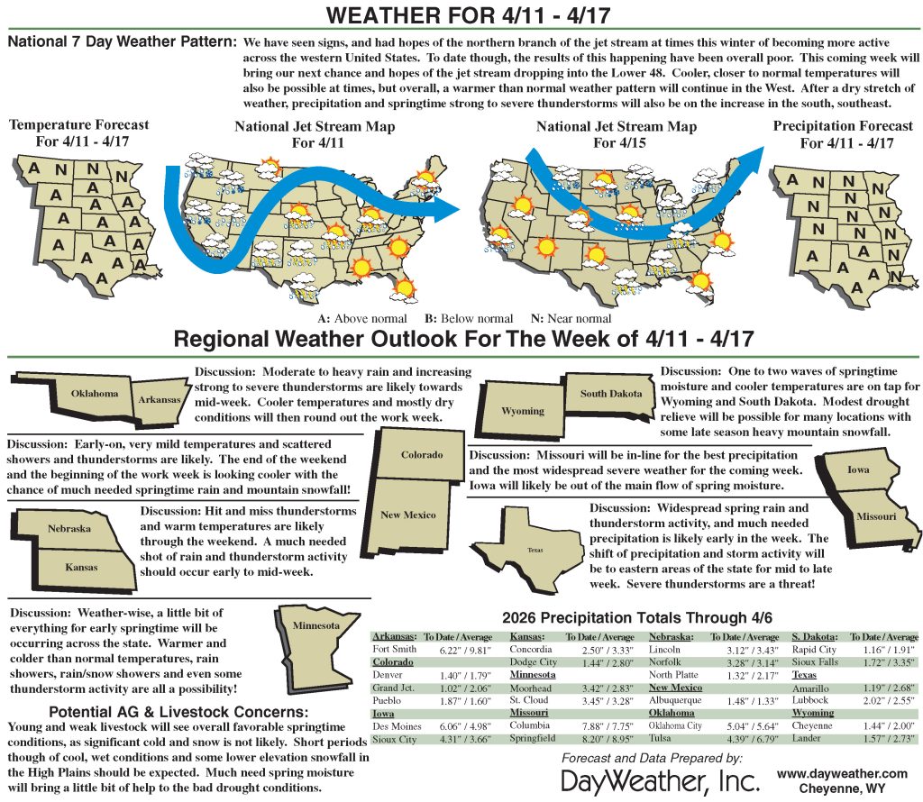
The National Weather Service’s Weather Prediction Center 7-Day Quantitative Precipitation Forecast calls for precipitation accumulations generally ranging from 1 to 4 inches across eastern portions of the Southern Plains, Midwest and Northeast. The heaviest totals (locally 3 to 4 inches) along a corridor extending from eastern Oklahoma and Arkansas through the mid-Mississippi Valley into eastern portions of the upper Midwest.
Across the High Plains, light-to-moderate precipitation accumulations ranging from 0.25 to 1.5 inches are expected, with the greatest totals across the eastern extent of the region. In the West, moderate-to-heavy liquid precipitation accumulations are expected across portions of the central and northern Rockies. Dry conditions are expected to prevail across much of the Southwest, including New Mexico.
The NWS 6– to 10-Day Temperature Outlook (valid April 14 to 18) calls for above-normal temperatures across nearly all of the contiguous U.S., with the highest probabilities across the eastern half of the country, including the Midwest. Below-normal temperatures are limited to areas along the broader U.S.–Canada border region in the Northern Plains and upper Midwest.
In terms of precipitation, the outlook calls for above-normal precipitation across the Far West, northern Rockies, New Mexico, Texas, the South (eastern extent), portions of the central and southern Plains and Midwest. Near-normal precipitation is expected across the Intermountain West, Desert Southwest and areas of the South.
David Simeral is with the Western Regional Climate Center.
Related Articles


