Limited moisture fell in parts of the Plains
The week was highlighted by a band of above-normal precipitation extending from south Texas into eastern Oklahoma, Missouri, Illinois, Michigan, and southern Wisconsin.
Many areas in this swath received greater than 150% of normal precipitation, with some locations exceeding 400% for the week. From the Ohio Valley south into the Southeast, conditions remained quite dry, with little to no precipitation recorded across most of the region.
The West was also largely dry, with only coastal areas of California and parts of the Pacific Northwest recording above-normal precipitation. Northern portions of the Northeast received rain, with areas from western New York into Maine recording 200% or more of normal precipitation.
Temperatures were near normal to slightly below normal across the West, with departures of up to 5 degrees Fahrenheit below normal in some areas. Portions of the central Plains, Midwest, Northeast, and Mid-Atlantic experienced above-normal temperatures, with departures of 5 to 10 degrees above normal. Temperatures in the Southeast were near to slightly above normal, with cooler conditions in the Florida Panhandle.
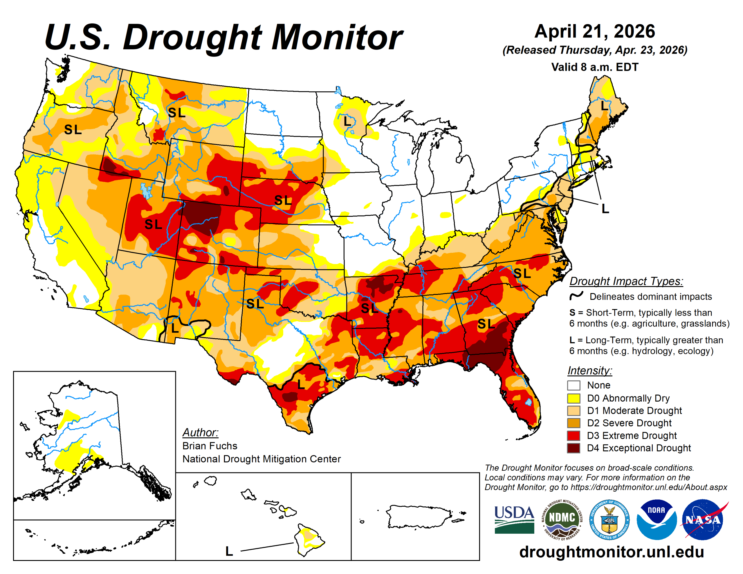
The U.S. Drought Monitor is jointly produced by the National Drought Mitigation Center at the University of Nebraska-Lincoln, the U.S. Department of Agriculture and the National Oceanic Atmospheric Administration. (Map courtesy of NDMC.)
Midwest
Temperatures were mostly above normal, with departures of 5 to 10 degrees across much of the region. The upper Midwest, particularly far northern Minnesota, saw near- to slightly below-normal temperatures.
Precipitation varied widely. Northwest Iowa and much of Minnesota were drier. Southern Missouri received needed precipitation, though improvements were limited due to persistent long-term dryness.
Northern Minnesota saw improvements in abnormally dry to severe drought conditions, though long-term drought signals remain. Southwestern Minnesota also saw slight expansion of moderate to severe drought.
High Plains
The region was mostly dry, with isolated rainfall in far southeast Nebraska, northern and southeast Kansas, and small areas of Colorado and North Dakota. Temperatures were generally above normal, with the warmest departures in southeast Nebraska and eastern Kansas.
Dryness and a warm spring led to widespread degradation. Extreme drought expanded across central and western Nebraska and into northwest Kansas. Severe drought expanded in central and southwest Kansas, with new extreme drought in far southwest Kansas.
Degradation continued across the plains of Wyoming and Colorado, with expansion of moderate to extreme drought. Extreme drought was also introduced in southern South Dakota.
Some improvements occurred in southeast Kansas, where moderate drought and abnormally dry conditions were reduced due to recent rainfall.
South
Temperatures were above normal across northern and eastern areas, with departures of 2 to 6 degrees. Across Texas, temperatures transitioned to below normal in southern and western areas, with departures of 2 to 6 degrees below normal.
The heaviest rainfall occurred from central to southern Texas into central and eastern Oklahoma, where totals reached 150 to 400% of normal. Elsewhere, conditions were mostly dry, including the Texas and Oklahoma Panhandles and much of Arkansas.
Where rainfall was sufficient in Texas and Oklahoma, drought conditions improved or were removed.
Extreme drought expanded in eastern Arkansas.
West
Precipitation was mixed. Isolated areas in Montana and Colorado recorded above-normal precipitation. However, most of the region remained drier than normal.
Temperatures were generally cooler than normal. Severe drought also expanded in western Wyoming, and extreme drought was introduced in southwestern Montana.
Oregon and Washington saw slight expansion of abnormally dry to moderate drought, with a small increase in severe drought in southwest Oregon. Southern California also experienced expansion of abnormally dry conditions.
Impacts are becoming more evident as snowpack has largely melted, and early runoff may contribute to future water supply issues.
Looking ahead
Over the next five to seven days, the highest precipitation chances are expected from the central Plains into the South, Midwest and parts of the Mid-Atlantic. The Pacific Northwest and northern Rockies may also see widespread precipitation.
Temperatures are expected to be above normal across the southern Plains, South and Southeast, with departures of 9 to 11 degrees in north Texas and Oklahoma and 5 to 7 degrees elsewhere. Cooler-than-normal temperatures are forecast for the northern Plains and northern Rockies. Departures of 9 to 12 degrees are forecast below normal in North Dakota and Montana.
The 6– to10-day outlook shows the highest chances for cooler-than-normal temperatures across the Plains and Midwest, with the greatest potential over the High Plains and upper Midwest.
The best chances for above-normal temperatures are in the Pacific Northwest and along the southern Gulf Coast. The greatest likelihood of above-normal precipitation is across much of the central and southern United States, with the highest chances in the Southwest. Meanwhile, the northern U.S. along the Canadian border is expected to have the best chances for below-normal precipitation.
Brian Fuchs is with the National Drought Mitigation Center.