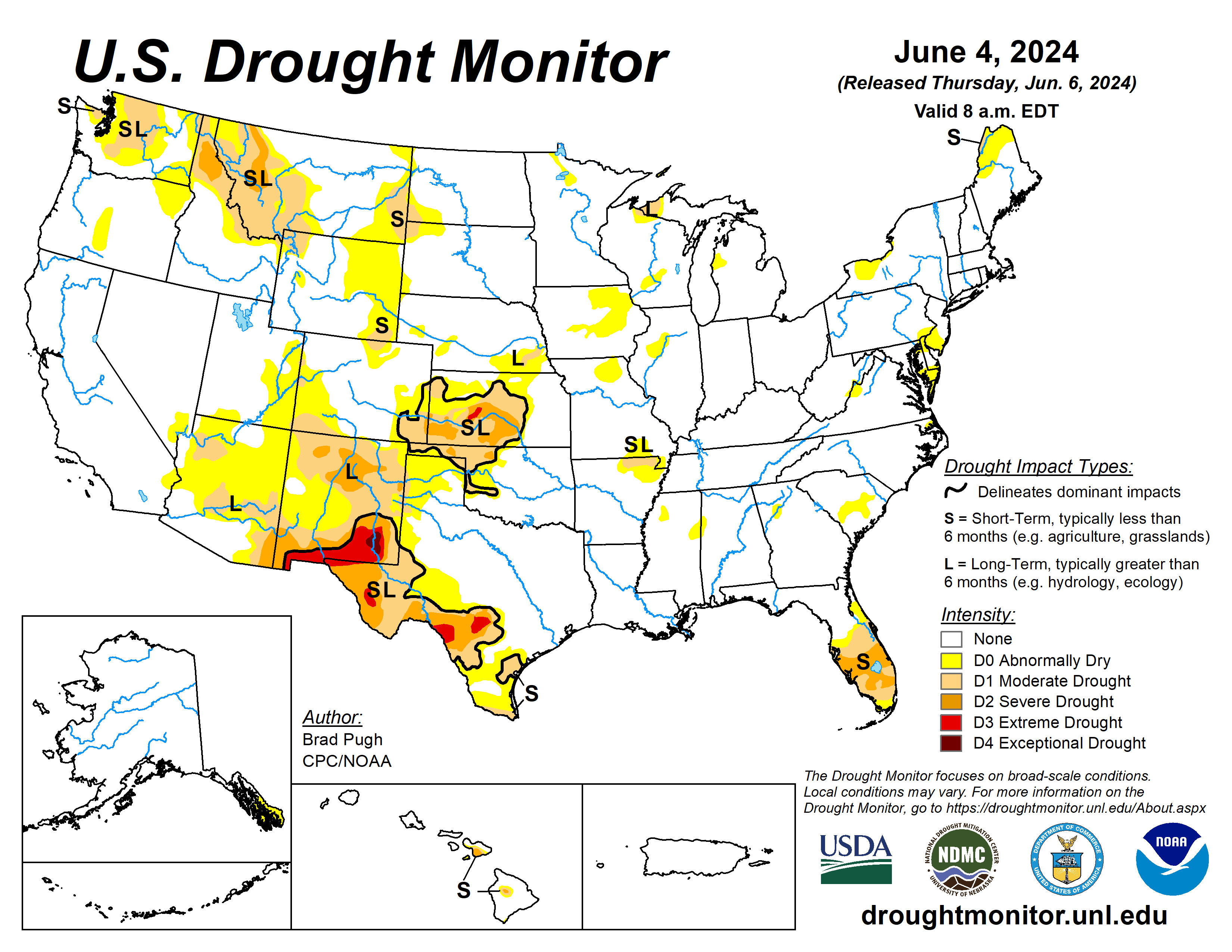
Following a stormy pattern with frequent periods of heavy precipitation and severe weather outbreaks, major drought improvement occurred this spring across the Great Plains and Mississippi Valley.
Recent heavy precipitation from May 28 to June 3 resulted in additional improvements to parts of the central and southern Great Plains. A dry start to the thunderstorm season and above-normal temperatures continued to result in drought expansion and intensification across the southern half of the Florida Peninsula.
Anomalously heavy precipitation for late May into the beginning of June led to drought improvement across parts of Washington, northern Idaho, and western Montana. Alaska and Puerto Rico remain drought-free, while drought of varying intensity persists for parts of Maui and the Big Island of Hawaii.
The U.S. Drought Monitor is jointly produced by the National Drought Mitigation Center at the University of Nebraska-Lincoln, the U.S. Department of Agriculture and the National Oceanic Atmospheric Administration. (Map courtesy of NDMC.)
South
Widespread heavy precipitation (2 to 5 inches, locally more) this past week generally occurred outside of existing Dx areas of the South region. However, the heavy precipitation did overspread a few of the Dx areas. Heavy precipitation along with considerations of Mitigation Center drought blends supported a 1-category improvement to parts of northwestern Oklahoma, Texas Panhandle, and south-central Texas.
Also, a slight reduction in abnormal dryness (was warranted for northeastern Arkansas. A 30- to 60-day standardized precipitation and evapotranspiration index and soil moisture indicators led to a 1-category degradation to parts of southern Texas and the middle Rio Grande Valley. Maximum temperatures have averaged 4 to 8 degrees Fahrenheit above normal during the past two weeks across the middle to lower Rio Grande Valley, which is likely drying out topsoil and a factor in worsening drought conditions.
Midwest
A very wet spring has resulted in nearly all of the Midwest becoming drought-free. Much of Iowa and southern Minnesota have received more than 15 inches of precipitation during the past 90 days.
Additional precipitation recently has led to a continued decrease in the coverage of abnormal dryness and moderate drought across Minnesota and Wisconsin. Only a small area of long-term D1 is now designated for portions of northern Wisconsin and the Upper Peninsula of Michigan.
The one exception to the spring wetness are small areas of northwestern Illinois and northern Missouri where 30-day precipitation deficits are increasing and soil moisture is beginning to decline.
High Plains
Widespread heavy precipitation (1 to 3 inches, locally more) resulted in a 1-category improvement to parts of Kansas, eastern Colorado, and southeastern Nebraska. A small area of long-term D1 was maintained for southeastern Nebraska that received less than 1 inch of precipitation and a long-term drought signal continues.
Based on neutral or wet soil moisture percentiles and NDMC drought blends, a 1-category improvement was made to northwestern North Dakota where more than 1 inch of precipitation occurred this past week. A 30- to 60-day SPI and soil moisture indicators supported an expansion of abnormal dryness and moderate drought for northern Colorado and southeastern Wyoming
West
Heavy precipitation (1.5 inches or more) this past week supported a 1-category improvement to parts of northeastern New Mexico. Recent precipitation with a relatively cool late spring and SPIs at multiple time scales resulted in a 1-category improvement to western Montana and adjacent areas of northern Idaho.
Unusually heavy precipitation (locally more than 3 inches) for the late spring led to a decrease in abnormal dryness and moderate drought coverage across parts of Washington. However, much of the existing moderate drought area of north-central Washington remained unchanged with precipitation averaging less than 50% of normal since Oct. 1, 2023.
Looking ahead
During the next five days, June 6 to 10, multiple cold fronts are forecast to progress across the eastern and central contiguous United States. The heaviest precipitation (more than 1 inch) is forecast for the Northeast, Tennessee Valley, and Ozarks region.
Locally heavy rainfall may accompany thunderstorms across the central to southern Great Plains.
The Climate Prediction Center’s six- to 10-day outlook (valid June 11-15, 2024) favors above-normal temperatures across most of the West and Great Plains. Below-normal precipitation probabilities are slightly elevated for much of the Corn Belt. Above-normal precipitation is favored for the central to southern Rockies and High Plains.
Brad Pugh is with the National Oceanic Atmospheric Administration and Climate Prediction Center.
Related Articles


