Some regions of High Plains received rain
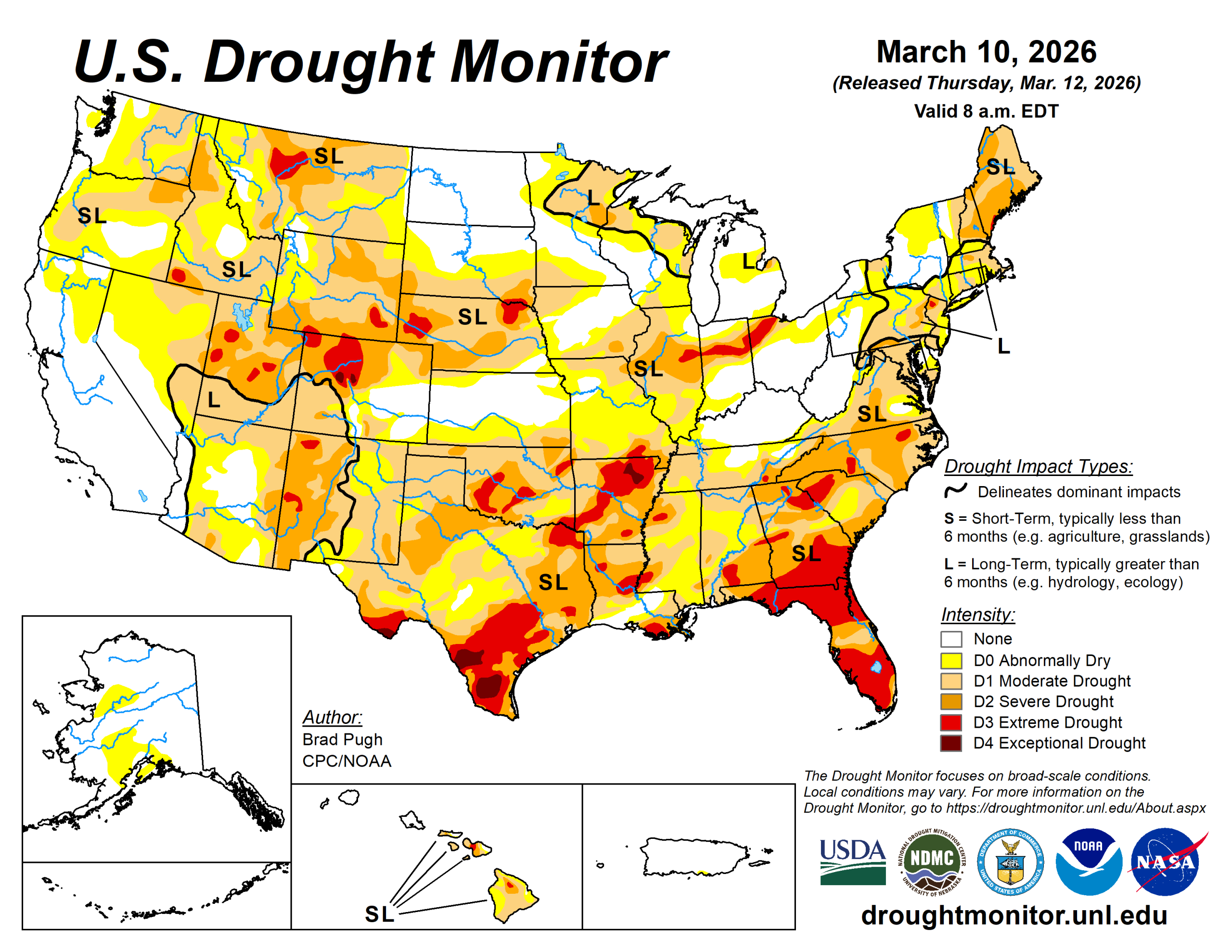
Following a drier-than-normal winter, a pattern change at the beginning of March resulted in widespread heavy precipitation (1 to 3 inches, locally more) and a 1-category improvement to parts of the Ohio and Middle to Lower Mississippi Valley.
This drought improvement extended east to the central Appalachians and the Northeast. However, a long-term drought continues for much of the Northeast. Despite the much-needed rainfall for portions of the southeast and southern Great Plains, severe to extreme drought persists for many areas. A low snowpack and early onset of snowmelt are a major drought concern for the West.
The U.S. Drought Monitor is jointly produced by the National Drought Mitigation Center at the University of Nebraska-Lincoln, the U.S. Department of Agriculture and the National Oceanic Atmospheric Administration. (Map courtesy of NDMC.)
South
Despite the locally heavy rainfall across the Lower Mississippi Valley along with eastern Oklahoma and Texas, only modest improvements were warranted as a favorable response among the various indicators was not enough to justify more widespread one-week changes.
However, targeted 1-category improvements were made to parts of northwestern Arkansas, eastern Oklahoma, eastern Texas, and the Lower Mississippi Valley where weekly precipitation amounts exceeded 2 inches.
In areas that missed out on the beneficial rainfall, drought intensified for parts of west-central Oklahoma and the Oklahoma Panhandle. A majority of the South region has received less than half their normal precipitation with a temperature departure of more than 6 degrees Fahrenheit above normal during the past 90 days.
These 3-month precipitation and temperature observations are consistent with a La Nina wintertime pattern.
Midwest
Major drought improvement occurred across the Midwest region as a couple of low-pressure systems and associated fronts tracked through the central U.S. during early March.
A 1-category improvement was generally made to areas that received 1.5 inches or more of precipitation from March 3 to 9. This included central to southern Indiana, Illinois, and Ohio along with east-central and southern Missouri.
Given the time of year, this recent precipitation was very beneficial in recharging soil moisture. There was a sharp cutoff to the heavier precipitation (near the Interstate Highway 70 corridor) with severe to extreme drought continuing farther to the north across Illinois, Indiana, and Ohio.
High Plains
Widespread drought of varying intensity continues across much of the central Great Plains and central Rockies. Drought expanded to include all of southwestern Colorado and intensified for northwestern parts of the state. The low snowpack throughout the central Rockies, especially Colorado, remains a major concern heading into the spring.
As of March 10, snow water equivalent for the river basins of Colorado is running below 70% of the 1991-2020 average. There were a couple exceptions to the worsening conditions. A wet snow (1 inch or more, liquid equivalent) supported the removal of extreme drought across parts of the Denver metro area.
Heavy rainfall (more than 1.5 inches) prompted small 1-category improvements to eastern Kansas and southeastern Nebraska.
West
The low snowpack throughout much of the West is a major concern heading into the spring. As of March 10, snow water equivalent is less than 40% of normal from the Cascades of the Pacific Northwest southward through the Great Basin and Four Corners region.
The 14-day temperatures, valid from Feb. 25 to March 10, have averaged 5 to degrees above normal. This warmer-than-normal end to February and start to March has led to an early onset of snowmelt for parts of the West.
Although California remains drought-free, SWE is 53% of normal statewide according to the California Department of Water Resources. Overall, only minor changes were made this past week to the West Region.
Based on increasing 60-day precipitation deficits and to reflect the low snowpack, abnormal dryness was added to parts of northern California. Drought expanded into southeastern Utah while intensifying to severe and extreme drought across northeastern and western portions of the state. Moderate drought was expanded across north-central to northeastern Washington along with central Oregon due to 30- to 90-day precipitation deficits and low snowpack.
Looking ahead
In the wake of a cold front, sharply colder temperatures are forecast to overspread the eastern U.S. on March 12.
A second and even stronger cold front is expected to progress east from the Great Plains to the East Coast by March 16. Following this strong March cold front, subfreezing temperatures are forecast to extend as far south as Oklahoma and the Texas Panhandle.
According to the Weather Prediction Center, 5-day precipitation amounts from March 12 to 16 are forecast to exceed 1 inch, liquid equivalent, across the Great Lakes and New England. Much needed rainfall is also anticipated for drought-stricken Florida. Elsewhere, drier weather is forecast for the Ohio Valley, Middle to Lower Mississippi Valley, and Great Plains.
During mid-March, dry weather will be accompanied by an increasing chance of record heat across California, the Great Basin, and Southwest. A powerful Kona low will bring heavy to excessive rainfall to Hawaii through at least March 14.
The National Weather Service’s 6- to 10-day outlook (valid March 17 to 21) leans toward below-normal temperatures for the East, while above-normal temperatures are likely from the West Coast to the Great Plains.
Above-normal temperature probabilities exceed 90% across most of California, the Great Basin, and Southwest. In contrast to the warmer–than-normal temperatures over the West, Alaska is likely to be colder-than-normal.
A majority of the lower 48 states are favored to have below-normal precipitation from March 17 to 21 with the largest below-normal precipitation probabilities (greater than 50%) forecast across the central to southern Great Plains, Southwest, and much of California.
Brad Pugh is with the National Oceanic Atmospheric Administration and Climate Prediction Center.