Over the past week, remnants of Beryl made their way up into the Midwest, bringing with them significant precipitation from east Texas all the way into Michigan. Another shot of significant rain at the end of the current period in the Midwest kept the region quite wet overall.
Significant precipitation along the eastern seaboard from New Jersey into the Carolinas was welcomed, but isolated to coastal areas. Much of the rest of the country was quite dry with only pockets of light precipitation. The warmest temperatures were over the West, with departures of 3 to 6 degrees Fahrenheit above normal widespread, and from Washington to California, with departures 9 to 12 degrees above normal.
The coolest temperatures were also associated with areas that picked up the best rains as temperatures from Texas into Arkansas and Missouri were up to 3 degrees below normal. Areas of the Northeast were also warmer than normal with departures of 6 to 9 degrees above normal.
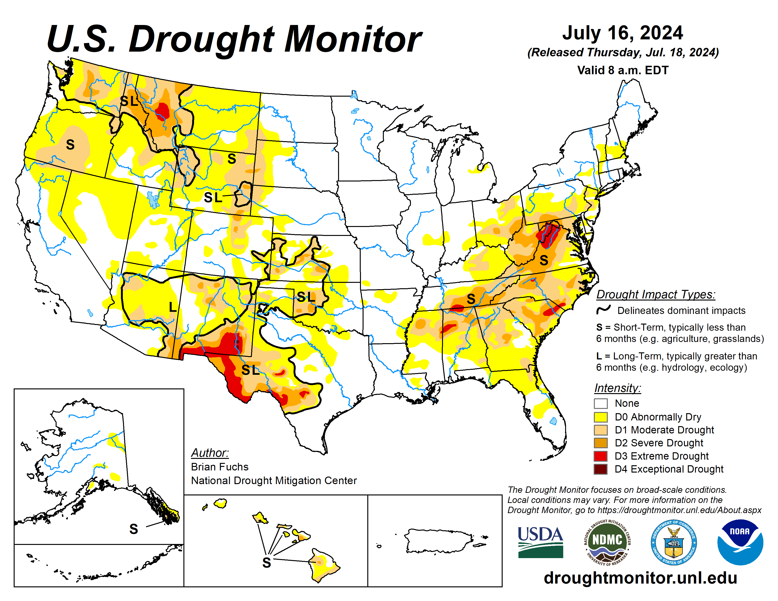
The U.S. Drought Monitor is jointly produced by the National Drought Mitigation Center at the University of Nebraska-Lincoln, the U.S. Department of Agriculture and the National Oceanic Atmospheric Administration. (Map courtesy of NDMC.)
South
It was a mostly dry week over the region with much of the area experiencing temperatures that were 2 to 3 degrees below normal. With short-term dryness returning to portions of north Texas and southern Oklahoma, abnormally dry conditions were expanded. Throughout the rest of the region, no other significant changes were made with status quo common across the region.
Midwest
Temperatures were mixed, between near normal to slightly below normal for much of the region to 2 to 4 degrees above normal over the northern and eastern extent of the region.
With the continued wet pattern over much of the region, abnormally dry conditions were removed from Iowa and northeast Missouri.
High Plains
A few pockets of above-normal precipitation were recorded in northwest South Dakota and north central North Dakota as well as in areas of eastern Kansas at the end of the current period.
Much of the rest of the region was dry or received minimal amounts of precipitation. Abnormally dry conditions were expanded in northwest and southeast Kansas as well as in eastern Colorado and western Nebraska.
Moderate drought was introduced over eastern Colorado and expanded in northwest Nebraska and southwest South Dakota as well as in eastern portions of Wyoming. Moderate and severe drought expanded in central Colorado as the foothills remained dry.
After several weeks of wet weather, some drying out is taking place in portions of the region, which is welcomed in some circumstances.
West
Warmer-than-normal temperatures dominated the region, with only portions of western Colorado and New Mexico below normal for the week with departures of up to 3 degrees below normal in New Mexico. Isolated rains in New Mexico were the only precipitation events of significance in the region.
Abnormally dry conditions were also expanded in southern Colorado. Moderate drought was expanded in western Wyoming, and Montana had severe drought expand broadly in the west while a new pocket of extreme drought was introduced.
Looking ahead
Over the next five to seven days, an active pattern appears to be developing from the Southwest, Plains, and into the Southeast and eastern seaboard. The most significant precipitation is anticipated over New Mexico, southern Colorado, northeast Texas, and from Louisiana through Virginia. Dry conditions are anticipated over much of the West and Midwest during this period.
Cooler-than-normal temperatures are anticipated over much of the Plains, South and into the Southeast, with some departures from normal approaching 9 to 11 degrees below normal in portions of Nebraska, Kansas and into Colorado and New Mexico.
Warmer-than-normal temperatures will dominate the West with departures of 11-13 degrees above normal over the Great Basin and into the northern Rocky Mountains. Near-normal temperatures are anticipated over other areas.
The 6- to 10-day outlook shows the greatest chances of below-normal temperatures will be over the southern Plains into portions of the South, Southwest and southern Midwest. The highest probability of above-normal precipitation will be over Texas with the area from the Southwest into the Mid-Atlantic also expected to have above-normal chances of above-normal precipitation. The area with the greatest chances of below-normal precipitation will be over the northern Rocky Mountains into the northern High Plains.
Brian Fuchs is with the National Drought Mitigation Center.


