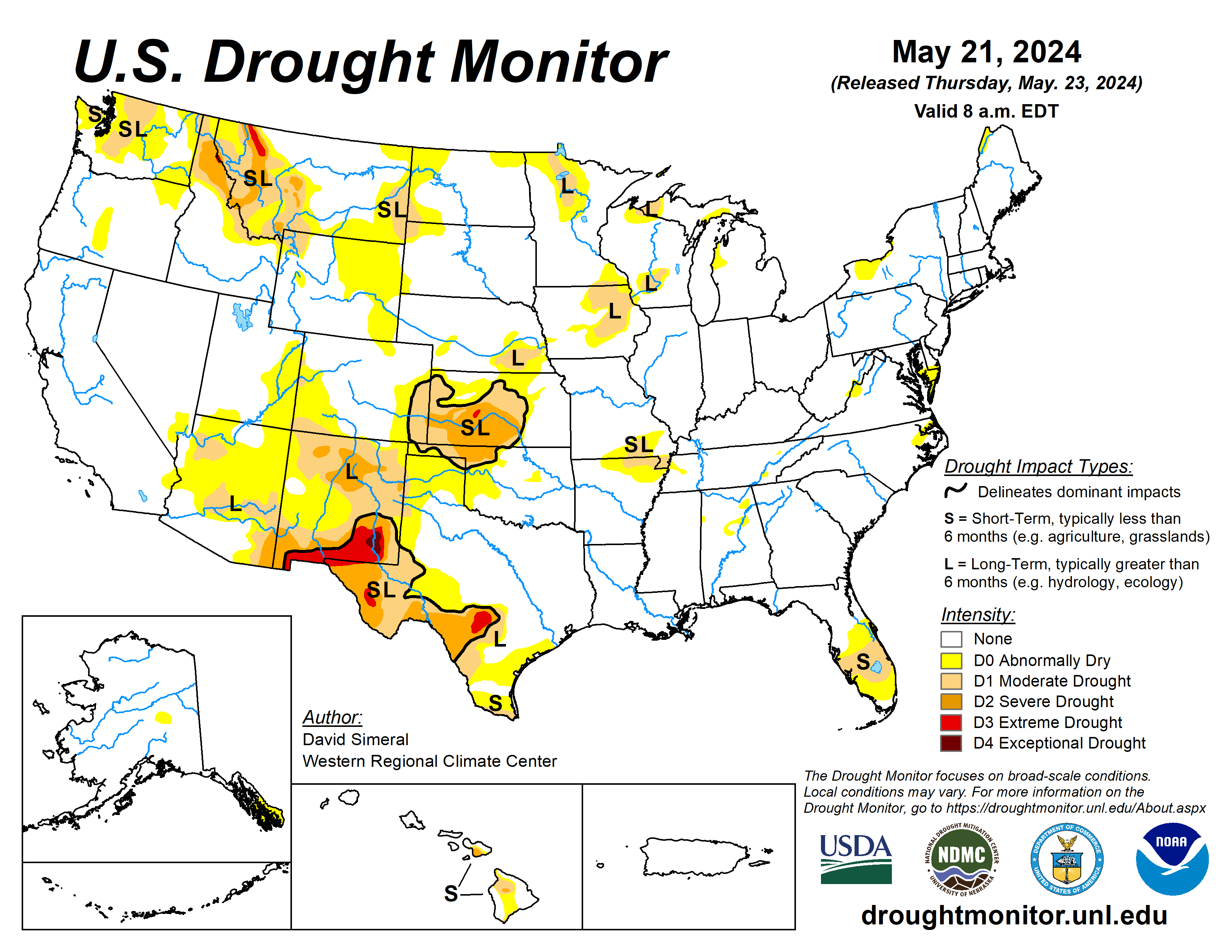
The latest U.S. Drought Monitor saw widespread improvement in drought-related conditions on the map across areas of the South, Plains, Midwest, Mid-Atlantic, and the West.
In the Plains and Midwest, locally heavy rainfall accumulations (up to 7 inches) were observed in drought-affected areas of Oklahoma, Kansas, Nebraska, Missouri, and Iowa. The rain led to continued improvements of conditions on the ground (vegetation health, soil moisture, surface water) as well as reductions in the longer-term precipitation deficits.
Isolated areas of central and west-central Texas saw minor improvements in response to recent rains and improving conditions during the past 30-day period. In southeastern Montana, recent rains erased water year (since Oct. 1) deficits and have improved soil moisture conditions and vegetation health. Across the border in the Bighorn Mountains of north-central Wyoming, areas of Moderate Drought were removed in response to above-normal snowpack conditions observed in its associated drainage basins.
The state’s largest reservoir in New Mexico along the Rio Grande is currently at 23% full (59% of average). Overall, looking at the broader drought situation across the conterminous United States, the total percentage of drought coverage is at its lowest since 2020.
The U.S. Drought Monitor is jointly produced by the National Drought Mitigation Center at the University of Nebraska-Lincoln, the U.S. Department of Agriculture and the National Oceanic Atmospheric Administration. (Map courtesy of NDMC.)
South
Across portions of the region, the active pattern continued with significant rainfall accumulations observed in portions of eastern Texas, southern Louisiana, and southern Mississippi, where 7-day totals ranged from 2 to 8 inches. Moreover, beneficial rainfall continued to help ease drought-related conditions in areas of Texas and Oklahoma.
Isolated rainfall activity this week led to some minor improvements in north-central Oklahoma, while areas of central and west-central Texas saw minor improvements. According to Water for Texas (May 22), statewide reservoirs are currently at 77.3% full with numerous reservoirs in the eastern part of the state near capacity, while many reservoirs in the western half of the state are experiencing below-normal levels.
In terms of pasture and range conditions across the region, the U.S. Department of Agriculture (May 19) is reporting statewide pasture and range conditions rated good to excellent as follows: Arkansas 61%, Louisiana 61%, Oklahoma 57%, and Texas 33%. Looking at climatological rankings for the January 2024-April 2024 period, the region experienced its 19th wettest (+2.32-inch anomaly) and the 11th warmest (+3.2 degrees Fahrenheit anomaly) on record, according to the National Oceanic Atmospheric Administration and National Centers for Environmental Information.
Midwest
There were reductions in areas of drought across portions of Iowa and Missouri. In Iowa, heavy rainfall (2 to 6+ inches) combined with improvements in conditions over a broader time scale led to reductions in areas of lingering drought across the state. According to the USDA (May 19), statewide pasture and range conditions rated good to excellent are as follows: Minnesota 61%, Iowa 72% and Missouri 71%. According to the NOAA NCEI’s climatological rankings for the March-April 2024 period, the Upper Midwest Climate Region observed its 10th wettest (+1.57 anomaly) and 12th warmest (+4.8 deg F anomaly) on record.
High Plains
Kansas, Nebraska, North Dakota, and the eastern Plains of Montana saw improvements in drought-affected areas. In Kansas and Nebraska, moderate to heavy rainfall accumulations (2 to 7+ inches) led to a reduction in areas of drought and provided a boost in soil moisture and streamflow levels.
According to the USDA (May 19), statewide pasture and range conditions rated good to excellent are as follows: North Dakota 68%, South Dakota 83%, Nebraska 56%, and Kansas 42%. According to the latest USDA Kansas Crop Progress and Condition Report (May 19), winter wheat condition was rated 11% very poor, 20% poor, 36% fair, 30% good, and 3% excellent. In terms of NOAA NCEI’s regional climatological rankings, the Great Plains Region observed its 44th wettest (near normal) and 12th warmest (+3.9 degrees F anomaly) January-April period on record.
West
Some minor improvements were made on the map in eastern New Mexico, southern Colorado, north-central Wyoming, and southeastern and central Montana. Looking at precipitation across the region, the start of the Water Year was not looking good with most of the region experiencing below-normal precipitation levels.
However, the period from Jan. 1 to May 21 was much more promising with above-normal precipitation observed across much of the region, with the exception of areas of western and central Montana as well as areas of the Southwest including eastern New Mexico.
In terms of snowpack, the Natural Resources Conservation Service SNOTEL network is reporting (May 21) the following region-level (2-digit HUC) snow water equivalent levels (percent of 1991-2020 median): Pacific Northwest 73%, Missouri 100%, California 147%, Great Basin 137%, Upper Colorado 112%, Arkansas-White-Red 140%, Lower Colorado 232%, and Rio Grande 52%. For the week, conditions were very dry across the region except for some isolated, light shower activity in eastern portions of New Mexico, Colorado, Wyoming, and Montana.
Looking ahead
The National Weather Service’s Weather Prediction Center 7-Day Quantitative Precipitation Forecast calls for moderate-to-heavy rainfall accumulations ranging from 2 to 5 inches across areas of the eastern portions of the Southern Plains (Oklahoma), South (northeastern Texas, and Arkansas). Lesser accumulations (1 to 2.5 inches) are expected in isolated areas of the Northern Rockies, and eastern plains of Montana.
Dry conditions are expected across the Southwest, and the southern extent of the Intermountain West.
The Climate Prediction Center’s six- to 10-day Outlook calls for a moderate-to-high probability of above-normal temperatures across much of the South. Likewise, above-normal temperatures are expected across most of the western U.S., with the exception of the Far West coastal areas from California to Washington where near-normal temperatures are expected. Conversely, below-normal temperatures are expected in eastern portions of the central Plains.
In terms of precipitation, there is a low-to-moderate probability of above-normal precipitation across the South while below-normal precipitation is expected across most of the western U.S. and northern Plains.
David Simeral is with the Western Regional Climate Center.
Related Articles


